I have a customer’s demand i’m struggling to fulfil:
In the project are two layers: Buildings and Parcels. It should be possible to select (with the select tool of LWC) some buildings and some parcels.
Then start a print layout (no atlas - the user should be able to define a the printed area) - buildings should be highlighted in blue, parcels in purple.
What i’ve tried so far: change the default project’s selection color to totally transparent + have a rule based style for the layers like that:
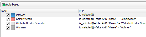
It works just as desired in QGIS - i select features, they get the assigned color in the printed pdf (not on the normal map canvas though - here the project’s default selection color overwrites the layer’s setting).
But in LWC, this does not work - the project’s default selection color overwrites the layer’s color, just like in the QGIS map canvas.
Do you have any idea how i cold circumvent this problem? Any creative solutions are welcome! 