Awesome! I’ve been wanting to be able to expand/collapse layer groups in the plugin for years. And the filter function makes it even better!
It makes my daily work much easier, especially when I have a lot of layers.
I’m getting an error message:
AttributeError: type object ‘LwcVersions’ has no attribute ‘find_from_metadata’
Traceback (most recent call last):
  File "C:\Users/wagne/AppData/Roaming/QGIS/QGIS3\profiles\default/python/plugins\lizmap\dialogs\main.py", line 1336, in panel_changed
    self.plausible.request_stat_event()
  File "C:\Users/wagne/AppData/Roaming/QGIS/QGIS3\profiles\default/python/plugins\lizmap\plausible.py", line 85, in request_stat_event
    if self._send_stat_event(metadata, qgis_server_version):
       ^^^^^^^^^^^^^^^^^^^^^^^^^^^^^^^^^^^^^^^^^^^^^^^^^^^^
  File "C:\Users/wagne/AppData/Roaming/QGIS/QGIS3\profiles\default/python/plugins\lizmap\plausible.py", line 158, in _send_stat_event
    lwc_version_branch = LwcVersions.find_from_metadata(current_metadata)
                         ^^^^^^^^^^^^^^^^^^^^^^^^^^^^^^
AttributeError: type object 'LwcVersions' has no attribute 'find_from_metadata'
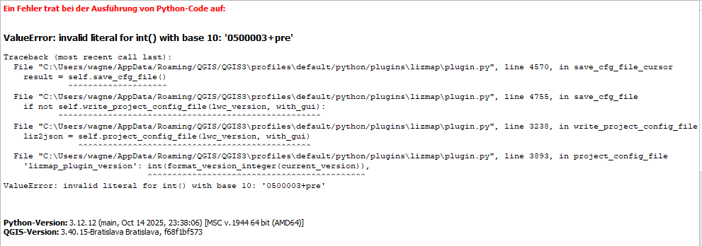
Thanks for the quick update. Now I’m getting this error:
ValueError: invalid literal for int() with base 10: ‘3-pre’
Traceback (most recent call last):
  File "C:\Users/wagne/AppData/Roaming/QGIS/QGIS3\profiles\default/python/plugins\lizmap\plugin.py", line 5549, in run
    self.update_plugin = plugin_manager.current_plugin_needs_update()
                         ^^^^^^^^^^^^^^^^^^^^^^^^^^^^^^^^^^^^^^^^^^^^
  File "C:\Users/wagne/AppData/Roaming/QGIS/QGIS3\profiles\default/python/plugins\lizmap\plugin_manager.py", line 85, in current_plugin_needs_update
    current_version = ServerManager.split_lizmap_version(current_version)
                      ^^^^^^^^^^^^^^^^^^^^^^^^^^^^^^^^^^^^^^^^^^^^^^^^^^^
  File "C:\Users/wagne/AppData/Roaming/QGIS/QGIS3\profiles\default/python/plugins\lizmap\server_lwc.py", line 1158, in split_lizmap_version
    int(lizmap_version_split[3]),
    ^^^^^^^^^^^^^^^^^^^^^^^^^^^^
ValueError: invalid literal for int() with base 10: '3-pre'
Thank you for the quick troubleshooting.
But does the link already contain the new version?
The file is exactly the same size as yesterday’s and the error still occurs.
While testing the alpha with a project using XYZ Tile layers (added via QGIS Browser → XYZ Tiles), I noticed that these layers are written to the CFG without an externalAccess block, while Google/OSM layers correctly get "type": "xyz" with direct tile URLs.
Would it be possible to automatically generate an externalAccess block for XYZ Tile layers in Plugin 5.0? This would make the behavior consistent and ensure they are loaded directly in the browser as tile requests rather than routed through QGIS Server.
For example OpenStreetMap: https://tile.openstreetmap.org/{z}/{x}/{y}.png
Or the Austrian basemap.at: https://mapsneu.wien.gv.at/basemap/geolandbasemap/normal/google3857/{z}/{y}/{x}.png
Both are added in QGIS via Browser → XYZ Tiles → New Connection. After saving the Lizmap CFG, neither gets an externalAccess block — while Google Satellite (which is added differently) does get one correctly.