[Geoserver-devel] 1.5.0 beta oracle problem

Andrea,

I think we've identifyed the problem.

We're using the thrunk with gt 2.3.1 because we need WCS and our NetCDF plug-in. In this case we encourter problems when displaying the layers form Oracle (express edition).
We've tested Geoserver 1.4.0-RC4, and everything goes fine, so I suspect changes in gt 2.3 jars used by Oracle plug-in

Have you got any clue ?

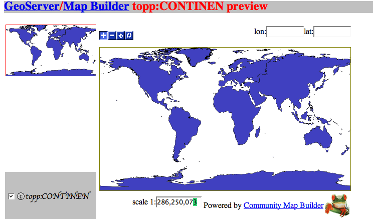
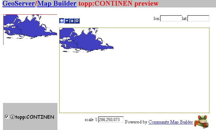
I join screenshots from 1.4.0-RC4 and 1.5.0-BETA1

=

------------------------------------------------------------------------

------------------------------------------------------------------------

------------------------------------------------------------------------

------------------------------------------------------------------------

Vincent Heurteaux
Société Geomatys
mob. 06 23 26 77 94
vincent.heurteaux@anonymised.com <mailto:vincent.heurteaux@anonymised.com>
http://www.geomatys.fr

Le 7 déc. 06 à 19:59, Andrea Aime a écrit :

Vincent Heurteaux ha scritto:

Ciao Andrea,
After investigations, it seems to be a Java heap space problem that generate a strange behavior.
will have a look at it tomorow.

Ah, bigger area, more data to handle... yet, it's somewhat funny, since
the streaming renderer is specifically designed for low memory consumption. Keep me posted, I'm curious.

Cheers
Andrea

=

Sorry I've forgotten to add these screens to the previous mail...

The DataStore Oracle spatial is built with the Geotools 2.2.2, and we want to make this work with Geotools 2.3.1, which will allow us to display images from both netCDF plugin and Oracle Spatial data.
We have seen that Oracle Spatial, in the pom.xml, uses the gt2-main jar as dependencies. So we have tried to add to Geoserver/WEB-INF/lib the gt2-main-2.2.2 jar, but it doesn't seems to use it instead of the gt2-main-2.3.1 jar (we have renamed gt2-main-2.2.2 to avoid conflict between two main jar in Geoserver).

Olivier.

(attachments)

World_1.4.0-RC4.png
World_1.5.0_BETA1.png

Are you using the forceXY=ture property when starting the Web Container?

On 12/8/06, olivier.terral <olivier.terral@anonymised.com> wrote:

Sorry I’ve forgotten to add these screens to the previous mail…

The DataStore Oracle spatial is built with the Geotools 2.2.2, and we
want to make this work with Geotools 2.3.1, which will allow us to
display images from both netCDF plugin and Oracle Spatial data.
We have seen that Oracle Spatial, in the pom.xml, uses the gt2-main jar
as dependencies. So we have tried to add to Geoserver/WEB-INF/lib the
gt2-main-2.2.2 jar, but it doesn’t seems to use it instead of the
gt2-main-2.3.1 jar (we have renamed gt2-main-2.2.2 to avoid conflict
between two main jar in Geoserver).

Olivier.


Take Surveys. Earn Cash. Influence the Future of IT
Join SourceForge.net’s Techsay panel and you’ll get the chance to share your
opinions on IT & business topics through brief surveys - and earn cash
http://www.techsay.com/default.php?page=join.php&p=sourceforge&CID=DEVDEV


Geoserver-devel mailing list
Geoserver-devel@lists.sourceforge.net
https://lists.sourceforge.net/lists/listinfo/geoserver-devel

Eng. Alessio Fabiani
Vice President/CTO GeoSolutions

http://www.geo-solutions.it


olivier.terral ha scritto:

Sorry I've forgotten to add these screens to the previous mail...

The DataStore Oracle spatial is built with the Geotools 2.2.2, and we want to make this work with Geotools 2.3.1, which will allow us to display images from both netCDF plugin and Oracle Spatial data.

He? No, you have to use the oracle data store that comes along with
2.3.x, not the one coming from 2.2.2. Besides that, try to use
the forcexy option and tell us how it goes.

Cheers
Andrea

Andrea Aime a écrit :

olivier.terral ha scritto:
  

Sorry I've forgotten to add these screens to the previous mail...

The DataStore Oracle spatial is built with the Geotools 2.2.2, and we want to make this work with Geotools 2.3.1, which will allow us to display images from both netCDF plugin and Oracle Spatial data.
    
He? No, you have to use the oracle data store that comes along with
2.3.x, not the one coming from 2.2.2. Besides that, try to use
the forcexy option and tell us how it goes.

Cheers
Andrea

Hello,

I'm using the geoserver of Olivier, but he is away for this week. I've added the option -Dorg.geotools.referencing.forceXY=true to the jvm option of tomcat, and we use the gt2-oracle-spatial-2.3.1 jar (as for the geoserver1.5.0 beta1).
The image is still reversed, as in previous screens, and I get the same error ...

Cédric B.

Cédric Briançon ha scritto:

Andrea Aime a écrit :

olivier.terral ha scritto:
  

Sorry I've forgotten to add these screens to the previous mail...

The DataStore Oracle spatial is built with the Geotools 2.2.2, and we want to make this work with Geotools 2.3.1, which will allow us to display images from both netCDF plugin and Oracle Spatial data.
    

He? No, you have to use the oracle data store that comes along with
2.3.x, not the one coming from 2.2.2. Besides that, try to use
the forcexy option and tell us how it goes.

Cheers
Andrea

Hello,

I'm using the geoserver of Olivier, but he is away for this week. I've added the option -Dorg.geotools.referencing.forceXY=true to the jvm option of tomcat, and we use the gt2-oracle-spatial-2.3.1 jar (as for the geoserver1.5.0 beta1).
The image is still reversed, as in previous screens, and I get the same error ...

Any hope you can give me that dataset as a shapefile I can import
into Oracle to test on my pc?

Cheers
Andrea

Andrea Aime a écrit :

Cédric Briançon ha scritto:

Andrea Aime a écrit :

olivier.terral ha scritto:

Sorry I've forgotten to add these screens to the previous mail...

The DataStore Oracle spatial is built with the Geotools 2.2.2, and we want to make this work with Geotools 2.3.1, which will allow us to display images from both netCDF plugin and Oracle Spatial data.
    

He? No, you have to use the oracle data store that comes along with
2.3.x, not the one coming from 2.2.2. Besides that, try to use
the forcexy option and tell us how it goes.

Cheers
Andrea

Hello,

I'm using the geoserver of Olivier, but he is away for this week. I've added the option -Dorg.geotools.referencing.forceXY=true to the jvm option of tomcat, and we use the gt2-oracle-spatial-2.3.1 jar (as for the geoserver1.5.0 beta1).
The image is still reversed, as in previous screens, and I get the same error ...

Any hope you can give me that dataset as a shapefile I can import
into Oracle to test on my pc?

Cheers
Andrea

Of course, please find the personal email that I've sent to you.

Thanks a lot,
Cédric B.

Cédric Briançon ha scritto:

Andrea Aime a écrit :

I'm using the geoserver of Olivier, but he is away for this week. I've added the option -Dorg.geotools.referencing.forceXY=true to the jvm option of tomcat, and we use the gt2-oracle-spatial-2.3.1 jar (as for the geoserver1.5.0 beta1).
The image is still reversed, as in previous screens, and I get the same error ...

Any hope you can give me that dataset as a shapefile I can import
into Oracle to test on my pc?

Ok, tested your shapefile. I've imported it with significant struggle
only with ogr2ogr utility included along with mapserver for windows,
since shp2sdo does not seem to work on my pc (generates .dat files
with errors according to sqlldr, possibly due to locale issues).

I never managed to get upside down images thought. What I've managed
to get instead is the random disappearance of polygons, and noticed
rendering is _very_ slow as well, even if I don't really know why
at the moment (don't know if it's caused by streaming renderer or
by the sdo decoder).

It turns out that Oracle has a bug, imho... basically, it cannot
handle properly sdo_relate that are expressed in lat/lon and that
do go near the 180/90 limits of the lat/lon space, whilst it works
fine if a bbox is used instead of a polygon.
See this thread and see for yourself:

http://forums.oracle.com/forums/thread.jspa?messageID=1596476&#1596476

Can you run the same queries against your Oracle install and tell
me if you get similar results?

I also opened a jira issue about this, since I can't work on it
right now:
http://jira.codehaus.org/browse/GEOT-1067

Cheers
Andrea

Hi there,

i'm having some problems with filtering results with the new geoserver,
or at least the oracle datastore component..

i am using geoserver 1.4.0 (stable) and the oracle extension linked from
your web page:
http://prdownloads.sourceforge.net/geoserver/geoserver-1.4.0-oracle-plug
in.zip?download

which turns out to be gt2-oracle-spatial-2.2.2-SNAPSHOT.jar and
ojdbc14.jar

i think they are 2 separate problems so here goes..

__________________________________
1.
I have a layer in geoserver called 'CADASTRE' that points to a table in
oracle 10g called CADASTRE.. the LOCATION and PARCEL fields are both
varchars in oracle.. and strings according to geoserver.

when i submit this getfeature request:
<?xml version="1.0"?>
<wfs:GetFeature service="WFS" version="1.0.0" outputFormat="GML2"
xmlns:topp="http://www.openplans.org/topp&quot;
xmlns:wfs="http://www.opengis.net/wfs&quot;
xmlns="http://www.opengis.net/ogc&quot;
xmlns:ogc="http://www.opengis.net/ogc&quot;
xmlns:gml="http://www.opengis.net/gml&quot;
xmlns:xsi="http://www.w3.org/2001/XMLSchema-instance&quot;
xsi:schemaLocation="http://www.opengis.net/wfs
http://schemas.opengis.net/wfs/1.0.0/WFS-basic.xsd&quot;&gt;
  <wfs:Query typeName="ntlis:CADASTRE">
    <ogc:Filter>
      <ogc:And>
        <ogc:PropertyIsEqualTo>
          <ogc:PropertyName>ntlis:PARCEL</ogc:PropertyName>
          <ogc:Literal>4812</ogc:Literal>
        </ogc:PropertyIsEqualTo>
        <ogc:PropertyIsEqualTo>
          <ogc:PropertyName>ntlis:LOCATION</ogc:PropertyName>
          <ogc:Literal>055</ogc:Literal>
        </ogc:PropertyIsEqualTo>
      </ogc:And>
    </ogc:Filter>
  </wfs:Query>
</wfs:GetFeature>

i get a stack trace from geoserver (attached as geoserver_log_1.txt),
where oracle is complaining 'ORA-01722: invalid number' referring to the
PARCEL value. looking the sql that geoserver executed (from the
geoserver logs) it goes:
SELECT "MI_PRINX", "LAISKEY", "LOCATION", "LTOCODE", "PARCEL",
"PART_PARCEL", "PARCEL_TYPE", "AREA_M2", "ST_NUMBER", "ST_PART",
"ST_NAME", "ST_TYPE", "ST_SUBURB", "SURVEY", "TEN_REF_TYPE",
"TEN_REF_NUM", "TEN_STATUS", "TEN_VOL_TYPE", "TEN_VOLUME", "TEN_FOLIO",
"TP_ZONE", "GEOMETRY", "STATUS_CODE", "PFI", "UFI", "FEAT_NAME",
"OWN_CATEGORY", "PROPERTY_NAME" FROM "CADASTRE" WHERE ("PARCEL" = 4812
AND "LOCATION" = 55)
note that has turned the input values into numbers (they're not '4812'
and '055').. adding the quotes manually fixes the query.

so it seems that you can't do a filter of a number (or rather of text
representing a number) against a text column.. geoserver should always
put quotes around values when they are destined for a string or
character type field.

________________________________________
2.
the propertyislike operator seems busted.. when i execute the following:

<?xml version="1.0"?>
<wfs:GetFeature service="WFS" version="1.0.0" outputFormat="GML2"
xmlns:topp="http://www.openplans.org/topp&quot;
xmlns:wfs="http://www.opengis.net/wfs&quot;
xmlns="http://www.opengis.net/ogc&quot;
xmlns:ogc="http://www.opengis.net/ogc&quot;
xmlns:gml="http://www.opengis.net/gml&quot;
xmlns:xsi="http://www.w3.org/2001/XMLSchema-instance&quot;
xsi:schemaLocation="http://www.opengis.net/wfs
http://schemas.opengis.net/wfs/1.0.0/WFS-basic.xsd&quot;&gt;
  <wfs:Query typeName="ntlis:PLACENAME">
    <ogc:Filter>
        <ogc:PropertyIsLike wildCard="%" singleChar="_" escape="\">
          <ogc:PropertyName>ntlis:NAME</ogc:PropertyName>
          <ogc:Literal>NIGHT%</ogc:Literal>
        </ogc:PropertyIsLike>
    </ogc:Filter>
  </wfs:Query>
</wfs:GetFeature>

i get no results.. looking at the sql in the geoserver log (attached as
geoserver_log_2.txt) there is no where clause on the sql.

SELECT "MI_PRINX", "PLACE_ID", "NAME", "TYPE_DESIGNATION", "DATA_TYPE",
"PLACE_STATUS", "HISTORY_ORIGIN", "DATE_REGISTERED", "LOCATION",
"LOCALITIES", "PARCELS", "LGAS", "ALTERNATE_NAMES", "GEOMETRY" FROM
"PLACENAME"

issueing the same request to geoserver 1.3.0 stable at the same oracle
table gives me the correct results.

is anyone else able to do proertyislike operations in the new geoserver
?

____________________________________________

running tomcat version "Apache Tomcat/4.1.27", jvm 1.4.2-b28, on win
2000.

thanks heaps,

-ivan
(attachments)

geoserver_log_1.txt (11 KB)
geoserver_log_2.txt (5.79 KB)

One more thing.. reverting my oracle extension to the old version:
http://downloads.sourceforge.net/geoserver/geoserver-1.3.x-oracle-ext.zi
p?modtime=1153852010&big_mirror=0

under 'datastore extras 1.3.x' in:
http://sourceforge.net/project/showfiles.php?group_id=25086&package_id=1
29885

still using geoserver 1.4.0 solves problem 2 but not problem 1.

-ivan

-----Original Message-----
From: geoserver-devel-bounces@lists.sourceforge.net
[mailto:geoserver-devel-bounces@lists.sourceforge.net] On Behalf Of Ivan
Price
Sent: Monday, 18 December 2006 2:40 PM
To: geoserver-devel@lists.sourceforge.net
Subject: [Geoserver-devel] 1.4.0 oracle spatial filter issues..

Hi there,

i'm having some problems with filtering results with the new geoserver,
or at least the oracle datastore component..

i am using geoserver 1.4.0 (stable) and the oracle extension linked from
your web page:
http://prdownloads.sourceforge.net/geoserver/geoserver-1.4.0-oracle-plug
in.zip?download

which turns out to be gt2-oracle-spatial-2.2.2-SNAPSHOT.jar and
ojdbc14.jar

i think they are 2 separate problems so here goes..

__________________________________
1.
I have a layer in geoserver called 'CADASTRE' that points to a table in
oracle 10g called CADASTRE.. the LOCATION and PARCEL fields are both
varchars in oracle.. and strings according to geoserver.

when i submit this getfeature request:
<?xml version="1.0"?>
<wfs:GetFeature service="WFS" version="1.0.0" outputFormat="GML2"
xmlns:topp="http://www.openplans.org/topp&quot;
xmlns:wfs="http://www.opengis.net/wfs&quot;
xmlns="http://www.opengis.net/ogc&quot;
xmlns:ogc="http://www.opengis.net/ogc&quot;
xmlns:gml="http://www.opengis.net/gml&quot;
xmlns:xsi="http://www.w3.org/2001/XMLSchema-instance&quot;
xsi:schemaLocation="http://www.opengis.net/wfs
http://schemas.opengis.net/wfs/1.0.0/WFS-basic.xsd&quot;&gt;
  <wfs:Query typeName="ntlis:CADASTRE">
    <ogc:Filter>
      <ogc:And>
        <ogc:PropertyIsEqualTo>
          <ogc:PropertyName>ntlis:PARCEL</ogc:PropertyName>
          <ogc:Literal>4812</ogc:Literal>
        </ogc:PropertyIsEqualTo>
        <ogc:PropertyIsEqualTo>
          <ogc:PropertyName>ntlis:LOCATION</ogc:PropertyName>
          <ogc:Literal>055</ogc:Literal>
        </ogc:PropertyIsEqualTo>
      </ogc:And>
    </ogc:Filter>
  </wfs:Query>
</wfs:GetFeature>

i get a stack trace from geoserver (attached as geoserver_log_1.txt),
where oracle is complaining 'ORA-01722: invalid number' referring to the
PARCEL value. looking the sql that geoserver executed (from the
geoserver logs) it goes:
SELECT "MI_PRINX", "LAISKEY", "LOCATION", "LTOCODE", "PARCEL",
"PART_PARCEL", "PARCEL_TYPE", "AREA_M2", "ST_NUMBER", "ST_PART",
"ST_NAME", "ST_TYPE", "ST_SUBURB", "SURVEY", "TEN_REF_TYPE",
"TEN_REF_NUM", "TEN_STATUS", "TEN_VOL_TYPE", "TEN_VOLUME", "TEN_FOLIO",
"TP_ZONE", "GEOMETRY", "STATUS_CODE", "PFI", "UFI", "FEAT_NAME",
"OWN_CATEGORY", "PROPERTY_NAME" FROM "CADASTRE" WHERE ("PARCEL" = 4812
AND "LOCATION" = 55) note that has turned the input values into numbers
(they're not '4812'
and '055').. adding the quotes manually fixes the query.

so it seems that you can't do a filter of a number (or rather of text
representing a number) against a text column.. geoserver should always
put quotes around values when they are destined for a string or
character type field.

________________________________________
2.
the propertyislike operator seems busted.. when i execute the following:

<?xml version="1.0"?>
<wfs:GetFeature service="WFS" version="1.0.0" outputFormat="GML2"
xmlns:topp="http://www.openplans.org/topp&quot;
xmlns:wfs="http://www.opengis.net/wfs&quot;
xmlns="http://www.opengis.net/ogc&quot;
xmlns:ogc="http://www.opengis.net/ogc&quot;
xmlns:gml="http://www.opengis.net/gml&quot;
xmlns:xsi="http://www.w3.org/2001/XMLSchema-instance&quot;
xsi:schemaLocation="http://www.opengis.net/wfs
http://schemas.opengis.net/wfs/1.0.0/WFS-basic.xsd&quot;&gt;
  <wfs:Query typeName="ntlis:PLACENAME">
    <ogc:Filter>
        <ogc:PropertyIsLike wildCard="%" singleChar="_" escape="\">
          <ogc:PropertyName>ntlis:NAME</ogc:PropertyName>
          <ogc:Literal>NIGHT%</ogc:Literal>
        </ogc:PropertyIsLike>
    </ogc:Filter>
  </wfs:Query>
</wfs:GetFeature>

i get no results.. looking at the sql in the geoserver log (attached as
geoserver_log_2.txt) there is no where clause on the sql.

SELECT "MI_PRINX", "PLACE_ID", "NAME", "TYPE_DESIGNATION", "DATA_TYPE",
"PLACE_STATUS", "HISTORY_ORIGIN", "DATE_REGISTERED", "LOCATION",
"LOCALITIES", "PARCELS", "LGAS", "ALTERNATE_NAMES", "GEOMETRY" FROM
"PLACENAME"

issueing the same request to geoserver 1.3.0 stable at the same oracle
table gives me the correct results.

is anyone else able to do proertyislike operations in the new geoserver
?

____________________________________________

running tomcat version "Apache Tomcat/4.1.27", jvm 1.4.2-b28, on win
2000.

thanks heaps,

-ivan
Ivan Price ha scritto:

Hi there,

i'm having some problems with filtering results with the new geoserver,
or at least the oracle datastore component..

i am using geoserver 1.4.0 (stable) and the oracle extension linked from
your web page:
http://prdownloads.sourceforge.net/geoserver/geoserver-1.4.0-oracle-plug
in.zip?download

which turns out to be gt2-oracle-spatial-2.2.2-SNAPSHOT.jar and
ojdbc14.jar

i think they are 2 separate problems so here goes..

Thank you for the report. I'll add it to a growing pile of issues, and
solve as I find enough time for it. Oracle datastore has no mantainer,
so it's hard to be prompt...

Cheers
Andrea

Ivan Price ha scritto:

Hi there,

i'm having some problems with filtering results with the new geoserver,
or at least the oracle datastore component..

i am using geoserver 1.4.0 (stable) and the oracle extension linked from
your web page:
http://prdownloads.sourceforge.net/geoserver/geoserver-1.4.0-oracle-plug
in.zip?download

which turns out to be gt2-oracle-spatial-2.2.2-SNAPSHOT.jar and
ojdbc14.jar

i think they are 2 separate problems so here goes..

__________________________________
1.
I have a layer in geoserver called 'CADASTRE' that points to a table in
oracle 10g called CADASTRE.. the LOCATION and PARCEL fields are both
varchars in oracle.. and strings according to geoserver.

when i submit this getfeature request:
<?xml version="1.0"?>
<wfs:GetFeature service="WFS" version="1.0.0" outputFormat="GML2"
xmlns:topp="http://www.openplans.org/topp&quot;
xmlns:wfs="http://www.opengis.net/wfs&quot;
xmlns="http://www.opengis.net/ogc&quot;
xmlns:ogc="http://www.opengis.net/ogc&quot;
xmlns:gml="http://www.opengis.net/gml&quot;
xmlns:xsi="http://www.w3.org/2001/XMLSchema-instance&quot;
xsi:schemaLocation="http://www.opengis.net/wfs
http://schemas.opengis.net/wfs/1.0.0/WFS-basic.xsd&quot;&gt;
  <wfs:Query typeName="ntlis:CADASTRE">
    <ogc:Filter>
      <ogc:And>
        <ogc:PropertyIsEqualTo>
          <ogc:PropertyName>ntlis:PARCEL</ogc:PropertyName>
          <ogc:Literal>4812</ogc:Literal>
        </ogc:PropertyIsEqualTo>
        <ogc:PropertyIsEqualTo>
          <ogc:PropertyName>ntlis:LOCATION</ogc:PropertyName>
          <ogc:Literal>055</ogc:Literal>
        </ogc:PropertyIsEqualTo>
      </ogc:And>
    </ogc:Filter>
  </wfs:Query>
</wfs:GetFeature>

i get a stack trace from geoserver (attached as geoserver_log_1.txt),
where oracle is complaining 'ORA-01722: invalid number' referring to the
PARCEL value. looking the sql that geoserver executed (from the
geoserver logs) it goes:
SELECT "MI_PRINX", "LAISKEY", "LOCATION", "LTOCODE", "PARCEL",
"PART_PARCEL", "PARCEL_TYPE", "AREA_M2", "ST_NUMBER", "ST_PART",
"ST_NAME", "ST_TYPE", "ST_SUBURB", "SURVEY", "TEN_REF_TYPE",
"TEN_REF_NUM", "TEN_STATUS", "TEN_VOL_TYPE", "TEN_VOLUME", "TEN_FOLIO",
"TP_ZONE", "GEOMETRY", "STATUS_CODE", "PFI", "UFI", "FEAT_NAME",
"OWN_CATEGORY", "PROPERTY_NAME" FROM "CADASTRE" WHERE ("PARCEL" = 4812
AND "LOCATION" = 55)
note that has turned the input values into numbers (they're not '4812'
and '055').. adding the quotes manually fixes the query.

so it seems that you can't do a filter of a number (or rather of text
representing a number) against a text column.. geoserver should always
put quotes around values when they are destined for a string or
character type field.

The above filter is parsed by the
Geotools Expression parser, which has no idea about what the literal
should be and tries integer, double and string parsing in order.
In your case, integer parsing succeeds and you're cooked.

I don't have a quick solution for this, literal expression parsing
does not have any context about what how the literal expression is
going to be used. Yet here guessing at parse time is necessary, because
the filter is not going to be applied in memory, but it's going
to be converted into a SQL statement. Conversion process does need
the right type of literal to work.

Adding context is going to be hard, since the whole parsing infrastructure is feature type unaware, both on the geoserver side, and
the geotools side. As you said, we would need to know the feature type,
know that the property expression is a String type, and hint the
expression parsers that literals should be parsed as Strings.
Justin, is the new parser on geotools trunk any better than the current one when it comes to this kind of issues?

Ivan, for a quick solution, the only trick I can suggest is to
add an alphabetical char at the start or end of your codes so that
those literals cannot be parsed to strings, that is:
* do a mass update on your db prefixing every char with a "C", for example, so that the parcel code becomes "C4812".
* update filters accordingly, then they will be parsed properly.

I'm going to write a separate mail for issue 2.
Cheers
Andrea

Ivan Price ha scritto:

One more thing.. reverting my oracle extension to the old version:
http://downloads.sourceforge.net/geoserver/geoserver-1.3.x-oracle-ext.zi
p?modtime=1153852010&big_mirror=0

under 'datastore extras 1.3.x' in:
http://sourceforge.net/project/showfiles.php?group_id=25086&package_id=1
29885

still using geoserver 1.4.0 solves problem 2 but not problem 1.

Yeah, you're right, it's a bug that creeped in around August and nobody
noticed: http://jira.codehaus.org/browse/GEOT-1077
I've already fixed it in all our geotools branches, so next Geoserver release should have the plugin working again.

Cheers
Andrea

Cédric Briançon ha scritto:

Andrea Aime a écrit :

Cédric Briançon ha scritto:

Andrea Aime a écrit :

olivier.terral ha scritto:

Sorry I've forgotten to add these screens to the previous mail...

The DataStore Oracle spatial is built with the Geotools 2.2.2, and we want to make this work with Geotools 2.3.1, which will allow us to display images from both netCDF plugin and Oracle Spatial data.
    

He? No, you have to use the oracle data store that comes along with
2.3.x, not the one coming from 2.2.2. Besides that, try to use
the forcexy option and tell us how it goes.

Cheers
Andrea

Hello,

I'm using the geoserver of Olivier, but he is away for this week. I've added the option -Dorg.geotools.referencing.forceXY=true to the jvm option of tomcat, and we use the gt2-oracle-spatial-2.3.1 jar (as for the geoserver1.5.0 beta1).
The image is still reversed, as in previous screens, and I get the same error ...

Any hope you can give me that dataset as a shapefile I can import
into Oracle to test on my pc?

Good news for you.
I've just fixed GEOT-1090 and GEOT-1067, which means Geoserver now deals
with lat/lon bbox queries just fine and it's a lot faster (4x in my tests) loading (and thus rendering) complex geometries.
Well, this is also thanks to you, that sample data made the two problems
quite evident :-p

Cheers
Andrea

Andrea, it's a great christmas gift :slight_smile:

Thanks a lot !

Cheers

Vincent
Le 28 déc. 06 à 10:06, Andrea Aime a écrit :

Cédric Briançon ha scritto:

Andrea Aime a écrit :

Cédric Briançon ha scritto:

Andrea Aime a écrit :

olivier.terral ha scritto:

Sorry I've forgotten to add these screens to the previous mail...

The DataStore Oracle spatial is built with the Geotools 2.2.2, and
we want to make this work with Geotools 2.3.1, which will allow us
to display images from both netCDF plugin and Oracle Spatial data.

He? No, you have to use the oracle data store that comes along with
2.3.x, not the one coming from 2.2.2. Besides that, try to use
the forcexy option and tell us how it goes.

Cheers
Andrea

Hello,

I'm using the geoserver of Olivier, but he is away for this week.
I've added the option -Dorg.geotools.referencing.forceXY=true to the
jvm option of tomcat, and we use the gt2-oracle-spatial-2.3.1 jar (as
for the geoserver1.5.0 beta1).
The image is still reversed, as in previous screens, and I get the
same error ...

Any hope you can give me that dataset as a shapefile I can import
into Oracle to test on my pc?

Good news for you.
I've just fixed GEOT-1090 and GEOT-1067, which means Geoserver now deals
with lat/lon bbox queries just fine and it's a lot faster (4x in my
tests) loading (and thus rendering) complex geometries.
Well, this is also thanks to you, that sample data made the two problems
quite evident :-p

Cheers
Andrea

-------------------------------------------------------------------------
Take Surveys. Earn Cash. Influence the Future of IT
Join SourceForge.net's Techsay panel and you'll get the chance to share your
opinions on IT & business topics through brief surveys - and earn cash
http://www.techsay.com/default.php?page=join.php&p=sourceforge&CID=DEVDEV
_______________________________________________
Geoserver-devel mailing list
Geoserver-devel@lists.sourceforge.net
https://lists.sourceforge.net/lists/listinfo/geoserver-devel

Vincent Heurteaux ha scritto:

Andrea, it's a great christmas gift :slight_smile:

Well, try it out and let us know how it works
for you. I've just checked it out on toy datasets :-p
Cheers
Andrea