Hello Everyone
···
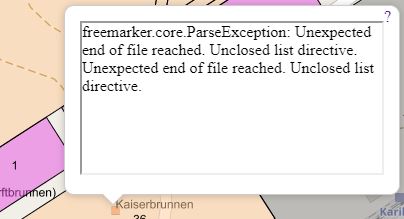
I am seeking advise regarding displaying pictures in the popup.
I did create a popup and also changed the template as per this tutorial,
http://docs.geoserver.org/latest/en/user/tutorials/GetFeatureInfo/index.html
My challenge is I cannot find this directory being refered to here in Geoserver
workspaces/topp/DS_poi/poi
I am assuming it is this directory on my computer,
C:\Program Files (x86)\GeoServer 2.12.1\data_dir\workspaces\topp\states_shapefile\states
under this directory there are five files
description.ftl
featuretype.xml
layer.xml
title.ftl
I am hoping it is the featuretype.xml file being referred to in the tutorial? my question, where do I paste the code being referred to in this tutorial in the xml file? Can I display my pictures straight from the attribute table or I need to do some other settings.
Kindly advise, your assistance will be highly appreciated.
Regards
Amelia
The pictures I would like to display are stored in an attribute table.
This pictures have
On Fri, Apr 6, 2018 at 1:52 AM, Nauwanga Nauwanga <amellynicodemus@anonymised.com> wrote:
Hello list,
I wanted to say I did manage to get rid of the X Frame error
Here is the solution,
https://helpx.adobe.com/target/kb/how-to-use-a-browser-extension-to-remove-x-frame-options-console.htmlThank you Dave for the hints,
On Tue, Apr 3, 2018 at 2:34 PM, Dave Potts <mrdapotts@anonymised.com> wrote:
Cors issues normally need to be resolved by your web server.
There is a cors filter that needs to be enabled in the current version of tomcat.
https://tomcat.apache.org/tomcat-8.0-doc/config/filter.htmlThere is also a plugin in for Chrome that will spoof the cors issue
https://chrome.google.com/webstore/detail/allow-control-allow-origi/nlfbmbojpeacfghkpbjhddihlkkiljbi?hl=enIn Spring is possible to turn a filter on.
see
On 3 April 2018 at 09:19, Nauwanga Nauwanga <amellynicodemus@anonymised.com> wrote:
If there is anyone who can assist with setting proxy for Openlayer 4, I will really appreciate.
Check out the vibrant tech community on one of the world’s most
engaging tech sites, Slashdot.org! http://sdm.link/slashdot
Geoserver-users mailing list
Please make sure you read the following two resources before posting to this list:
- Earning your support instead of buying it, but Ian Turton: http://www.ianturton.com/talks/foss4g.html#/
- The GeoServer user list posting guidelines: http://geoserver.org/comm/userlist-guidelines.html
If you want to request a feature or an improvement, also see this: https://github.com/geoserver/geoserver/wiki/Successfully-requesting-and-integrating-new-features-and-improvements-in-GeoServer
Geoserver-users@anonymised.comrge.net
https://lists.sourceforge.net/lists/listinfo/geoserver-users
On Tue, Apr 3, 2018 at 9:55 AM, Nauwanga Nauwanga <amellynicodemus@anonymised.com> wrote:
Hi Andria,
Yes I am still busy researching, I believe I have found the solution which has to do with cross domain. I therefore need to set my proxy accordingly.
I am getting the error that says access to image has been blocked by CORS policy.
The real issue is now how to set proxy in Openlayer 4.
I have found some links with the setting but not working?
Here are some links with the solution
http://www.fernandoquadro.com.br/html/2009/03/05/configurando-o-proxyhost-no-openlayers/https://khayer.wordpress.com/2010/07/14/open-layer-with-geosever/
Still busy trying to get this figured and working.
Kind regards
Amelia
On Thu, Mar 29, 2018 at 11:07 AM, Andrea Aime <andrea.aime@anonymised.com> wrote:
HI Amelia,
I see you got no answer here, maybe you should ask on the OpenLayers mailing list too?Cheers
Andrea
On Wed, Mar 28, 2018 at 4:33 AM, Nauwanga Nauwanga <amellynicodemus@anonymised.com> wrote:
Hello Everyone
I am new to Web Mapping and I have been trying to get the feature info to work for my WMS when I group them with Openlayer. I am using Openlayer 4.
I am trying the following to no success
http://openlayers.org/en/latest/examples/getfeatureinfo-tile.htmlThank you for your kind help.
Kind regards
Amelia
Check out the vibrant tech community on one of the world’s most
engaging tech sites, Slashdot.org! http://sdm.link/slashdot
Geoserver-users mailing list
Please make sure you read the following two resources before posting to this list:
- Earning your support instead of buying it, but Ian Turton: http://www.ianturton.com/talks/foss4g.html#/
- The GeoServer user list posting guidelines: http://geoserver.org/comm/userlist-guidelines.html
If you want to request a feature or an improvement, also see this: https://github.com/geoserver/geoserver/wiki/Successfully-requesting-and-integrating-new-features-and-improvements-in-GeoServer
Geoserver-users@anonymised.comrge.net
https://lists.sourceforge.net/lists/listinfo/geoserver-users
–
Regards,
Andrea Aime
==
GeoServer Professional Services from the experts! Visit http://goo.gl/it488V for more information.
Ing. Andrea Aime
@geowolf
Technical Lead
GeoSolutions S.A.S.
Via di Montramito 3/A
55054 Massarosa (LU)
phone: +39 0584 962313
fax: +39 0584 1660272
mob: +39 339 8844549
http://www.geo-solutions.it
http://twitter.com/geosolutions_it
AVVERTENZE AI SENSI DEL D.Lgs. 196/2003
Le informazioni contenute in questo messaggio di posta elettronica e/o nel/i file/s allegato/i sono da considerarsi strettamente riservate. Il loro utilizzo è consentito esclusivamente al destinatario del messaggio, per le finalità indicate nel messaggio stesso. Qualora riceviate questo messaggio senza esserne il destinatario, Vi preghiamo cortesemente di darcene notizia via e-mail e di procedere alla distruzione del messaggio stesso, cancellandolo dal Vostro sistema. Conservare il messaggio stesso, divulgarlo anche in parte, distribuirlo ad altri soggetti, copiarlo, od utilizzarlo per finalità diverse, costituisce comportamento contrario ai principi dettati dal D.Lgs. 196/2003.
The information in this message and/or attachments, is intended solely for the attention and use of the named addressee(s) and may be confidential or proprietary in nature or covered by the provisions of privacy act (Legislative Decree June, 30 2003, no.196 - Italy’s New Data Protection Code).Any use not in accord with its purpose, any disclosure, reproduction, copying, distribution, or either dissemination, either whole or partial, is strictly forbidden except previous formal approval of the named addressee(s). If you are not the intended recipient, please contact immediately the sender by telephone, fax or e-mail and delete the information in this message that has been received in error. The sender does not give any warranty or accept liability as the content, accuracy or completeness of sent messages and accepts no responsibility for changes made after they were sent or for other risks which arise as a result of e-mail transmission, viruses, etc.
