On Thu, Jul 23, 2015 at 3:03 PM, Miles Jordan <miles@anonymised.com>
wrote:
Hi all,
I’m working on a project that uses grib data, so have been using the
community grib extension.
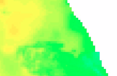
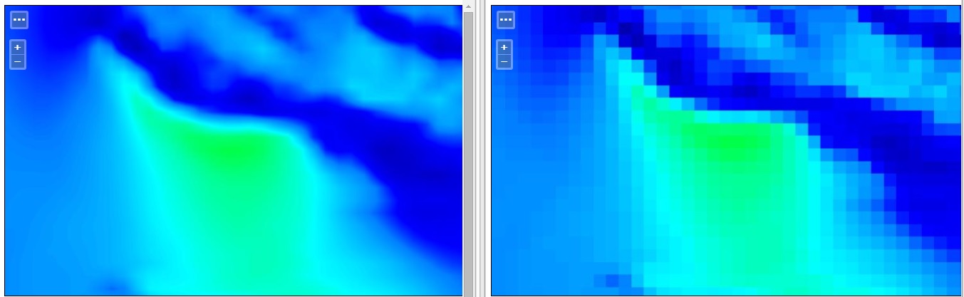
I’ve not been able to successfully use antialiasing properly on any of my
example grib files in wms requests. All I can seem to get is pixelated
output.
I’ve tried all the different settings for antialiasing in the WMS settings.
Antialiasing? You mean interpolation right?
Antialiasing is only for vector data, what controls how smooth the output
is, it's interpolation.
It seems your data is interpolated "nearest neighbor", you might want to
try out bilinear or bicubic?
Which version of GeoServer are you using btw?
Cheers
Andrea
--
GeoServer Professional Services from the experts! Visit
http://goo.gl/it488V for more information.
Ing. Andrea Aime
@geowolf
Technical Lead
GeoSolutions S.A.S.
Via Poggio alle Viti 1187
55054 Massarosa (LU)
Italy
phone: +39 0584 962313
fax: +39 0584 1660272
mob: +39 339 8844549
http://www.geo-solutions.it
http://twitter.com/geosolutions_it
*AVVERTENZE AI SENSI DEL D.Lgs. 196/2003*
Le informazioni contenute in questo messaggio di posta elettronica e/o
nel/i file/s allegato/i sono da considerarsi strettamente riservate. Il
loro utilizzo è consentito esclusivamente al destinatario del messaggio,
per le finalità indicate nel messaggio stesso. Qualora riceviate questo
messaggio senza esserne il destinatario, Vi preghiamo cortesemente di
darcene notizia via e-mail e di procedere alla distruzione del messaggio
stesso, cancellandolo dal Vostro sistema. Conservare il messaggio stesso,
divulgarlo anche in parte, distribuirlo ad altri soggetti, copiarlo, od
utilizzarlo per finalità diverse, costituisce comportamento contrario ai
principi dettati dal D.Lgs. 196/2003.
The information in this message and/or attachments, is intended solely for
the attention and use of the named addressee(s) and may be confidential or
proprietary in nature or covered by the provisions of privacy act
(Legislative Decree June, 30 2003, no.196 - Italy's New Data Protection
Code).Any use not in accord with its purpose, any disclosure, reproduction,
copying, distribution, or either dissemination, either whole or partial, is
strictly forbidden except previous formal approval of the named
addressee(s). If you are not the intended recipient, please contact
immediately the sender by telephone, fax or e-mail and delete the
information in this message that has been received in error. The sender
does not give any warranty or accept liability as the content, accuracy or
completeness of sent messages and accepts no responsibility for changes
made after they were sent or for other risks which arise as a result of
e-mail transmission, viruses, etc.
-------------------------------------------------------