Hello all,
Today I had time to examine geoservers log file and there I found the following related to the image mosaic creation:
---
2014-12-02 10:29:25,989 WARN [gce.imagemosaic] - Unable to close indexingjava.io.IOException: Error occured calculating bounds for sst_SQLserver3
java.lang.RuntimeException: java.io.IOException: Error occured calculating bounds for sst_SQLserver3
at org.geotools.jdbc.JDBCFeatureSource.getBoundsInternal(JDBCFeatureSource.java:529)
at org.geotools.jdbc.JDBCFeatureStore.getBoundsInternal(JDBCFeatureStore.java:189)
.
.
.
Caused by: java.io.IOException: Error occured calculating bounds for sst_SQLserver3
at org.geotools.jdbc.JDBCDataStore.getBounds(JDBCDataStore.java:1264)
at org.geotools.jdbc.JDBCFeatureSource.getBoundsInternal(JDBCFeatureSource.java:522)
... 147 more
Caused by: java.io.IOException
at org.geotools.data.sqlserver.SQLServerDialect.decodeGeometry(SQLServerDialect.java:576)
at org.geotools.data.sqlserver.SQLServerDialect.decodeGeometryEnvelope(SQLServerDialect.java:600)
at org.geotools.jdbc.JDBCDataStore.getBounds(JDBCDataStore.java:1250)
... 148 more
Caused by: org.opengis.referencing.NoSuchAuthorityCodeException: No code "EPSG:0" from authority "European Petroleum Survey Group" found for object of type "IdentifiedObject".
at org.geotools.referencing.factory.AbstractAuthorityFactory.noSuchAuthorityCode(AbstractAuthorityFactory.java:951)
at org.geotools.referencing.factory.PropertyAuthorityFactory.getWKT(PropertyAuthorityFactory.java:316)
...160 more
---
And true enough when I checked the database, even though the image geometry itself seemed to be created correctly in SQL Server table, it lacked SRID. Just in case, I also checked the image used for the creation of the data store with gdalinfo and to me it seems to be fine what comes to coordinate system (at the bottom).
So, can we just conclude that ImageMosaic plugin does not work with SQL Server or is there some workaround? I wondered about using a geometry metadata table but I couldn't find any way to make the plugin use that instead of the index table.
Kind regards,
Samuli
D:\samulin\GeoServer >gdalinfo D:\eo_temp\N18_14may29_0248_sst_n.tif
Driver: GTiff/GeoTIFF
Files: D:\eo_temp \N18_14may29_0248_sst_n.tif
Size is 2373, 1693
Coordinate System is:
GEOGCS["WGS 84",
DATUM["WGS_1984",
SPHEROID["WGS 84",6378137,298.257223563,
AUTHORITY["EPSG","7030"]],
AUTHORITY["EPSG","6326"]],
PRIMEM["Greenwich",0],
UNIT["degree",0.0174532925199433],
AUTHORITY["EPSG","4326"]]
Origin = (9.275271000000000,70.310935999999998)
Pixel Size = (0.010000000000000,-0.010000000000000)
Metadata:
AREA_OR_POINT=Area
TIFFTAG_SOFTWARE=MATLAB 8.0, Mapping Toolbox 3.6
Image Structure Metadata:
COMPRESSION=LZW
INTERLEAVE=BAND
Corner Coordinates:
Upper Left ( 9.2752710, 70.3109360) ( 9d16'30.98"E, 70d18'39.37"N)
Lower Left ( 9.2752710, 53.3809360) ( 9d16'30.98"E, 53d22'51.37"N)
Upper Right ( 33.0052710, 70.3109360) ( 33d 0'18.98"E, 70d18'39.37"N)
Lower Right ( 33.0052710, 53.3809360) ( 33d 0'18.98"E, 53d22'51.37"N)
Center ( 21.1402710, 61.8459360) ( 21d 8'24.98"E, 61d50'45.37"N)
Band 1 Block=2373x1 Type=Float32, ColorInterp=Gray
-----Alkuperäinen viesti-----
Lähettäjä: Neuvonen Samuli [mailto:samuli.neuvonen@…3235…]
Lähetetty: 1. joulukuuta 2014 16:29
Vastaanottaja: Simone Giannecchini
Kopio: geoserver-users@lists.sourceforge.net
Aihe: Re: [Geoserver-users] ImageMosaic indexes & DBMSs
Hello,
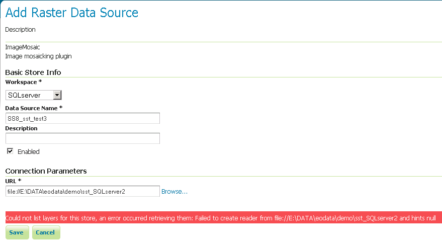
And thanks for your tips. I tried this but failed:
"Could not list layers for this store, an error occurred retrieving them: Failed to create reader from file://E:\DATA\eodata\demo\sst_SQLserver2 and hints null"
I'll attach a screenshot, in case it makes a difference. I checked the database and to me it seemed that the proper table had been created with the appropriate data in it (fid, the_geom, location, time). So to me it seems the problem cannot be with database privileges etc. I switched another datastore.properties -file to the image folder (E:\DATA\eodata\demo\sst_SQLserver2 above) defining a PostGIS-database and clicked Save again: the datastore was created without problems. So something does go wrong with SQL Server.
I'll discuss this with my more database-wise colleagues and let you know if we can figure it out.
Regards,
Samuli
-----Alkuperäinen viesti-----
Lähettäjä: simboss1@...84... [mailto:simboss1@…84…] Puolesta Simone Giannecchini
Lähetetty: 28. marraskuuta 2014 20:39
Vastaanottaja: Neuvonen Samuli
Kopio: geoserver-users@lists.sourceforge.net
Aihe: Re: [Geoserver-users] ImageMosaic indexes & DBMSs
Ciao,
that list is up-to-date.
This does not mean that SQL Server is known to not work with ImageMosaic, it simply means it has never been tested.
ImageMosaic uses a standard datastore underneath so generally speaking it should work with SQL Server. I would suggest doing a test with a datastore.properties similar to the following:
where you need to customize keys and values according to what is described in this page:
SPI=org.geotools.data.sqlserver.SQLServerDataStoreFactory
port=1521
host=localhost
database=dbname
Loose\ bbox=true
Estimated\ extends=false
user=usr
passwd=psw
validate \connections=true
Connection\ timeout=10
The point is that you are telling ImageMosacis to connect and take control over a DBMS through the SQL Server plugin hence in the datastore.properties you configure the params to connect to it likewise you do in the UI og GeoServer. Mind the spaces in the keys'
names.
Let us know how it goes, ideally it should work seamlessly whicle oracle was a pain due the caseness of the names. If not we'll improve ImageMosaic to handle this case.
Of course you need to install SQL Server support installed.
Regards,
Simone Giannecchini
GeoServer Professional Services from the experts! Visit
GeoSolutions for more information.
Ing. Simone Giannecchini
@simogeo
Founder/Director
GeoSolutions S.A.S.
Via Poggio alle Viti 1187
55054 Massarosa (LU)
Italy
phone: +39 0584 962313
fax: +39 0584 1660272
mob: +39 333 8128928
http://twitter.com/geosolutions_it
-------------------------------------------------------
AVVERTENZE AI SENSI DEL D.Lgs. 196/2003
Le informazioni contenute in questo messaggio di posta elettronica e/o nel/i file/s allegato/i sono da considerarsi strettamente riservate.
Il loro utilizzo è consentito esclusivamente al destinatario del messaggio, per le finalità indicate nel messaggio stesso. Qualora riceviate questo messaggio senza esserne il destinatario, Vi preghiamo cortesemente di darcene notizia via e-mail e di procedere alla distruzione del messaggio stesso, cancellandolo dal Vostro sistema.
Conservare il messaggio stesso, divulgarlo anche in parte, distribuirlo ad altri soggetti, copiarlo, od utilizzarlo per finalità diverse, costituisce comportamento contrario ai principi dettati dal D.Lgs. 196/2003.
The information in this message and/or attachments, is intended solely for the attention and use of the named addressee(s) and may be confidential or proprietary in nature or covered by the provisions of privacy act (Legislative Decree June, 30 2003, no.196 - Italy's New Data Protection Code).Any use not in accord with its purpose, any disclosure, reproduction, copying, distribution, or either dissemination, either whole or partial, is strictly forbidden except previous formal approval of the named addressee(s). If you are not the intended recipient, please contact immediately the sender by telephone, fax or e-mail and delete the information in this message that has been received in error. The sender does not give any warranty or accept liability as the content, accuracy or completeness of sent messages and accepts no responsibility for changes made after they were sent or for other risks which arise as a result of e-mail transmission, viruses, etc.
On Thu, Nov 27, 2014 at 9:51 AM, Neuvonen Samuli <samuli.neuvonen@...3235...> wrote:
Hello all,
I found this tutorial on mosaic datastores
http://geoserver.geo-solutions.it/multidim/en/imagemosaic/mosaic_datas
tore.html
and I was wondering if the list of supported DBMSs is still up-to-date
i.e. the supported databases are
- Postgis
- Oracle
- H2
and SQL Server is not supported? My ICT-people are really reluctant to allow the use of anything but the institute standard...
Kind regards,
Samuli Neuvonen
----------------------------------------------------------------------
-------- Download BIRT iHub F-Type - The Free Enterprise-Grade BIRT
Server from Actuate! Instantly Supercharge Your Business Reports and
Dashboards with Interactivity, Sharing, Native Excel Exports, App
Integration & more Get technology previously reserved for
billion-dollar corporations, FREE
http://pubads.g.doubleclick.net/gampad/clk?id=157005751&iu=/4140/ostg.
clktrk _______________________________________________
Geoserver-users mailing list
Geoserver-users@lists.sourceforge.net
https://lists.sourceforge.net/lists/listinfo/geoserver-users