Hi everyone,
I am experiencing some trouble publishing polygon layers as I realized that the WFS service, apparently, simplify my features. And, as we are dealing with property limits, this simplification cannot occur.
I am using version 2.16 of Geoserver, store type is POSTGIS, and the option ‘Support on the fly geometry simplification’ in the Store configuration is unchecked.
Would any of you know how I can solve this problem, and present the WFS according to the existing geometry of my database?
**Link of the service:**http://geovis.dev.planejamento.gov.br/vetor/spunet/ows?version=1.0.0&layer=spunet%3Aareas_uniao
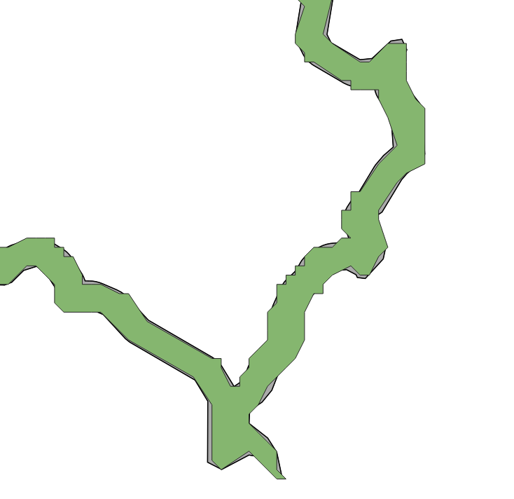
Abaixo, segue print da apresentação da mesma camada em WMS(cinza) e WFS(verde-simplificada).
Below is a print of the presentation of the same layer in WMS (gray-like database) and WFS (green-simplified).
···
Jessica
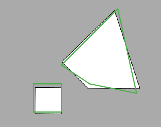
Strange, I'm not aware that anybody will automagically simplify stuff.
Even loading both layers in epsg:4674 I still get different data.
Are we 100% sure it is exact the same data?
Because even holes in polygons (like 4 coordinates, so NON simplified) seem to have other coordinates (see screenie).
Regards,
Richard Duivenvoorde
On 2/23/21 5:30 PM, Jéssica Carvalho Vianna Co wrote:
Hi everyone,
I am experiencing some trouble publishing polygon layers as I realized that the WFS service, apparently, simplify my features. And, as we are dealing with property limits, this simplification cannot occur.
I am using version 2.16 of Geoserver, store type is POSTGIS, and the option 'Support on the fly geometry simplification' in the Store configuration is unchecked.
Would any of you know how I can solve this problem, and present the WFS according to the existing geometry of my database?
*Link of the service:*http://geovis.dev.planejamento.gov.br/vetor/spunet/ows?version=1.0.0&layer=spunet%3Aareas_uniao
Abaixo, segue print da apresentação da mesma camada em WMS(cinza) e WFS(verde-simplificada).
Below is a print of the presentation of the same layer in WMS (gray-like database) and WFS (green-simplified).
Jessica
_______________________________________________
Geoserver-users mailing list
Please make sure you read the following two resources before posting to this list:
- Earning your support instead of buying it, but Ian Turton: http://www.ianturton.com/talks/foss4g.html#/
- The GeoServer user list posting guidelines: http://geoserver.org/comm/userlist-guidelines.html
If you want to request a feature or an improvement, also see this: https://github.com/geoserver/geoserver/wiki/Successfully-requesting-and-integrating-new-features-and-improvements-in-GeoServer
Geoserver-users@lists.sourceforge.net
https://lists.sourceforge.net/lists/listinfo/geoserver-users
Hi Jessica,
GeoServer WFS has no actual “geometry simplification” option. However, there is a setting that acts
as a simplifier of sorts: the number of decimals used to represent ordinates.
Typically 6 is enough for data in geographic coordinates, did you set it to a smaller value?
The effect is to basically snap every point to a grid (it always is, but becomes visible if the
number of decimals is small).
Cheers
Andrea
···
Regards, Andrea Aime
== GeoServer Professional Services from the experts! Visit http://goo.gl/it488V for more information. == Ing. Andrea Aime @geowolf Technical Lead GeoSolutions S.A.S. Via di Montramito 3/A 55054 Massarosa (LU) phone: +39 0584 962313 fax: +39 0584 1660272 mob: +39 339 8844549 http://www.geo-solutions.it http://twitter.com/geosolutions_it ------------------------------------------------------- Con riferimento alla normativa sul trattamento dei dati personali (Reg. UE 2016/679 - Regolamento generale sulla protezione dei dati “GDPR”), si precisa che ogni circostanza inerente alla presente email (il suo contenuto, gli eventuali allegati, etc.) è un dato la cui conoscenza è riservata al/i solo/i destinatario/i indicati dallo scrivente. Se il messaggio Le è giunto per errore, è tenuta/o a cancellarlo, ogni altra operazione è illecita. Le sarei comunque grato se potesse darmene notizia. This email is intended only for the person or entity to which it is addressed and may contain information that is privileged, confidential or otherwise protected from disclosure. We remind that - as provided by European Regulation 2016/679 “GDPR” - copying, dissemination or use of this e-mail or the information herein by anyone other than the intended recipient is prohibited. If you have received this email by mistake, please notify us immediately by telephone or e-mail.
Hi Andrea,
The setting of the max number decimal was set indeed at “0”!!! Changed it to It worked!!!
···
De: Andrea Aime andrea.aime@anonymised.com
Enviado: terça-feira, 23 de fevereiro de 2021 14:34
Para: Jéssica Carvalho Vianna Co jessica.co@anonymised.com
Cc: GeoServer Mailing List List geoserver-users@anonymised.come.net
Assunto: Re: [Geoserver-users] Issue: WFS simplifies features automatically
Hi Jessica,
GeoServer WFS has no actual “geometry simplification” option. However, there is a setting that acts
as a simplifier of sorts: the number of decimals used to represent ordinates.
Typically 6 is enough for data in geographic coordinates, did you set it to a smaller value?
The effect is to basically snap every point to a grid (it always is, but becomes visible if the
number of decimals is small).
Cheers
Andrea
On Tue, Feb 23, 2021 at 6:12 PM Jéssica Carvalho Vianna Co <jessica.co@anonymised.com> wrote:
Hi everyone,
I am experiencing some trouble publishing polygon layers as I realized that the WFS service, apparently, simplify my features. And, as we are dealing with property limits, this simplification cannot occur.
I am using version 2.16 of Geoserver, store type is POSTGIS, and the option ‘Support on the fly geometry simplification’ in the Store configuration is unchecked.
Would any of you know how I can solve this problem, and present the WFS according to the existing geometry of my database?
Link of the service:http://geovis.dev.planejamento.gov.br/vetor/spunet/ows?version=1.0.0&layer=spunet%3Aareas_uniao
Abaixo, segue print da apresentação da mesma camada em WMS(cinza) e WFS(verde-simplificada).
Below is a print of the presentation of the same layer in WMS (gray-like database) and WFS (green-simplified).
![]()
Jessica
Geoserver-users mailing list
Please make sure you read the following two resources before posting to this list:
If you want to request a feature or an improvement, also see this: https://github.com/geoserver/geoserver/wiki/Successfully-requesting-and-integrating-new-features-and-improvements-in-GeoServer
Geoserver-users@lists.sourceforge.net
https://lists.sourceforge.net/lists/listinfo/geoserver-users
–
Regards, Andrea Aime
== GeoServer Professional Services from the experts! Visit http://goo.gl/it488V for more information. == Ing. Andrea Aime @geowolf Technical Lead GeoSolutions S.A.S. Via di Montramito 3/A 55054 Massarosa (LU) phone: +39 0584 962313 fax: +39 0584 1660272 mob: +39 339 8844549 http://www.geo-solutions.it http://twitter.com/geosolutions_it ------------------------------------------------------- Con riferimento alla normativa sul trattamento dei dati personali (Reg. UE 2016/679 - Regolamento generale sulla protezione dei dati “GDPR”), si precisa che ogni circostanza inerente alla presente email (il suo contenuto, gli eventuali allegati, etc.) è un dato la cui conoscenza è riservata al/i solo/i destinatario/i indicati dallo scrivente. Se il messaggio Le è giunto per errore, è tenuta/o a cancellarlo, ogni altra operazione è illecita. Le sarei comunque grato se potesse darmene notizia. This email is intended only for the person or entity to which it is addressed and may contain information that is privileged, confidential or otherwise protected from disclosure. We remind that - as provided by European Regulation 2016/679 “GDPR” - copying, dissemination or use of this e-mail or the information herein by anyone other than the intended recipient is prohibited. If you have received this email by mistake, please notify us immediately by telephone or e-mail.
1 Like
Helped me also, same issue. Thanks!
2 Likes