Since there was problem with my previous post, i'm posting it once again ..
Sorry for duplicity ...
Hi, im quite new in GeoServer world, but anyway ..
Im trying to create some working example of new store of type Application
Schema DataAccess
I have data in postgre database, for this example i just have a simple
table: service(id uuid, name text)
Then i have datastore.xml:
<dataStore>
<id>ct_service_datastore</id>
<name>ct_service</name>
<description>Service</description>
<enabled>true</enabled>
<workspace>
<id>ct_workspace</id>
</workspace>
<connectionParameters>
<entry key="namespace">http://geoserver.org/ct</entry>
<entry key="dbtype">app-schema</entry>
<entry key="url">file:workspaces/ct/ct_service/ct_service.xml</entry>
</connectionParameters>
<__default>false</__default>
</dataStore>
and ct_service.xml
<?xml version="1.0" encoding="UTF-8"?>
<as:AppSchemaDataAccess
xmlns:as="http://www.geotools.org/app-schema"
xmlns:xsi="http://www.w3.org/2001/XMLSchema-instance"
xsi:schemaLocation="http://www.geotools.org/app-schema
AppSchemaDataAccess.xsd">
<namespaces>
<Namespace>
<prefix>ct</prefix>
<uri>http://www.geoserver.org/ct</uri>
</Namespace>
<Namespace>
<prefix>xlink</prefix>
<uri>http://www.w3.org/1999/xlink</uri>
</Namespace>
</namespaces>
<sourceDataStores>
<DataStore>
<id>datastore</id>
<parameters>
<Parameter>
<name>dbtype</name>
<value>postgisng</value>
</Parameter>
<Parameter>
<name>schema</name>
<value>public</value>
</Parameter>
<Parameter>
<name>database</name>
<value>ctTest</value>
</Parameter>
<Parameter>
<name>host</name>
<value>localhost</value>
</Parameter>
<Parameter>
<name>port</name>
<value>5432</value>
</Parameter>
<Parameter>
<name>user</name>
<value>ct</value>
</Parameter>
<Parameter>
<name>passwd</name>
<value>ct</value>
</Parameter>
<Parameter>
<name>Expose primary keys</name>
<value>true</value>
</Parameter>
<Parameter>
<name>Connection timeout</name>
<value>20</value>
</Parameter>
<Parameter>
<name>namespace</name>
<value>http://geoserver.org/ct</value>
</Parameter>
</parameters>
</DataStore>
</sourceDataStores>
<targetTypes>
<FeatureType>
<schemaUri>http://localhost/ct/service.xsd</schemaUri>
</FeatureType>
</targetTypes>
<typeMappings>
<FeatureTypeMapping>
<sourceDataStore>datastore</sourceDataStore>
<sourceType>service</sourceType>
<targetElement>ct:service</targetElement>
<attributeMappings>
<AttributeMapping>
<targetAttribute>
ct:Id
</targetAttribute>
<idExpression>
<OCQL>id</OCQL>
</idExpression>
</AttributeMapping>
<AttributeMapping>
<targetAttribute>
ct:Code
</targetAttribute>
<idExpression>
<OCQL>code</OCQL>
</idExpression>
</AttributeMapping>
</attributeMappings>
</FeatureTypeMapping>
</typeMappings>
</as:AppSchemaDataAccess>
and service.xsd:
<?xml version="1.0" encoding="utf-8"?>
<xs:schema
xmlns:xs="http://www.w3.org/2001/XMLSchema"
xmlns:wfs="http://www.opengis.net/wfs"
xmlns:ct="http://geoserver.org/ct"
xmlns:xsi="http://www.w3.org/2001/XMLSchema-instance"
xmlns:gml="http://www.opengis.net/gml"
attributeFormDefault="unqualified"
elementFormDefault="qualified"
targetNamespace="http://geoserver.org/ct">
<xs:element name="service" type="ct:serviceType"/>
<xs:complexType name="serviceType">
<xs:sequence>
<xs:element name="Id" type="xs:string" />
<xs:element name="Code" type="xs:string" />
</xs:sequence>
</xs:complexType>
</xs:schema>
and featuretype.xml:
<featureType>
<id>service_featuretype</id>
<name>service</name>
<nativeName>service</nativeName>
<namespace>
<id>ct_namespace</id>
</namespace>
<title>ct_service</title>
<keywords>
<string>features</string>
<string>ct_service</string>
</keywords>
<srs>EPSG:3067</srs>
<nativeBoundingBox>
<minx>43547.78932226647</minx>
<maxx>764796.7155847414</maxx>
<miny>6523158.091198515</miny>
<maxy>7795461.187543589</maxy>
<crs class="projected">EPSG:3067</crs>
</nativeBoundingBox>
<latLonBoundingBox>
<minx>15.053785270822843</minx>
<maxx>33.993537468175056</maxx>
<miny>58.60745650071967</miny>
<maxy>70.26415661214813</maxy>
<crs>EPSG:4326</crs>
</latLonBoundingBox>
<projectionPolicy>FORCE_DECLARED</projectionPolicy>
<enabled>true</enabled>
<store class="dataStore">
<id>ct_service_datastore</id>
</store>
<maxFeatures>0</maxFeatures>
<numDecimals>0</numDecimals>
<overridingServiceSRS>false</overridingServiceSRS>
<skipNumberMatched>false</skipNumberMatched>
<circularArcPresent>false</circularArcPresent>
</featureType>
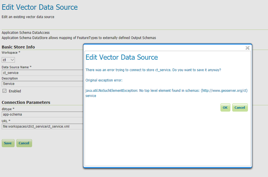
But when i open store in GeoServer and try to save, i get error:
Edit Vector Data Source
There was an error trying to connect to store ct_service. Do you want to
save it anyway?
Original exception error:
java.util.NoSuchElementException: No top level element found in schemas:
{http://www.geoserver.org/ct\}service
I googled some advices, but was not able to fix this issue ![]()
Could someone check the files and help me, please?
Thanks a lot for any clue,
Lge
--
Sent from: http://osgeo-org.1560.x6.nabble.com/GeoServer-User-f3786390.html