Geoserver does not seem to correctly display dashed lines when I use stroke-dasharray the below is an example
#777
3.0
2 3
round
round
I noticed the openlayers bug: GeoServer returns a dash array with a space at the end. This is not properly rendered in SVG because an extra comma is placed at the end.
It points to the geoserver returned dasharray as the problem.
http://trac.openlayers.org/ticket/2271
I am using geoserver 1.7.7 is anyone having a similar problem.
Thanks,
John
–
John J. Mitchell
John Mitchell ha scritto:
Geoserver does not seem to correctly display dashed lines when I use stroke-dasharray the below is an example
<LineSymbolizer>
<Stroke>
<CssParameter name="stroke">#777</CssParameter>
<CssParameter name="stroke-width">3.0</CssParameter>
<CssParameter name="stroke-dasharray">2 3</CssParameter>
<CssParameter name="stroke-linejoin">round</CssParameter>
<CssParameter name="stroke-linecap">round</CssParameter>
</Stroke> </LineSymbolizer>
I noticed the openlayers bug: GeoServer returns a dash array with a space at the end. This is not properly rendered in SVG because an extra comma is placed at the end.
It points to the geoserver returned dasharray as the problem.
http://trac.openlayers.org/ticket/2271
I am using geoserver 1.7.7 is anyone having a similar problem.
I'm quite confused... what protocol and format are you using?
Are you asking GeoServer to generate SVG and then try to display
it with OpenLayers?
Cheers
Andrea
--
Andrea Aime
OpenGeo - http://opengeo.org
Expert service straight from the developers.
I am just using the geoserver demo app against a geoserver layer and the dashed lines are not showing up correctly.
John
On Wed, Nov 4, 2009 at 4:56 PM, Andrea Aime <aaime@anonymised.com> wrote:
John Mitchell ha scritto:
Geoserver does not seem to correctly display dashed lines when I use stroke-dasharray the below is an example
#777
3.0
2 3
round
round
I noticed the openlayers bug: GeoServer returns a dash array with a space at the end. This is not properly rendered in SVG because an extra comma is placed at the end.
It points to the geoserver returned dasharray as the problem.
http://trac.openlayers.org/ticket/2271
I am using geoserver 1.7.7 is anyone having a similar problem.
I’m quite confused… what protocol and format are you using?
Are you asking GeoServer to generate SVG and then try to display
it with OpenLayers?
Cheers
Andrea
–
Andrea Aime
OpenGeo - http://opengeo.org
Expert service straight from the developers.
–
John J. Mitchell
John Mitchell ha scritto:
I am just using the geoserver demo app against a geoserver layer and the dashed lines are not showing up correctly.
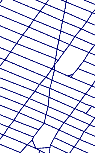
Not showing up correctly does not tell me what's wrong with them.
Anyways, tried your style and in fact does not look like a dashed line
(dash1.png). However the bubbly appearance is due to the style, you
have a think line and the dash array elements are comparable, or smaller, than the line width. Add to that that round line cap extend
the line with a semicircular cap with 1.5 pixel radius and the result in
dash1.png is actually to be expected.
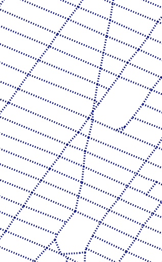
I've then removed the line cap and end and got dash2.png, which is probably close to what you asked, but I agree it does not really fit
expectations.
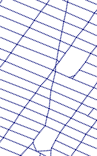
So I went into the code and changed some hints we provide to java2d
to draw lines and got dash3.png, which is probably what you wanted to get?
Hmm... too bad the hint was introduced to improve the appearance of
continuous lines, I did not notice it was worsening the dashed lines
results at the same time
Cheers
Andrea
--
Andrea Aime
OpenGeo - http://opengeo.org
Expert service straight from the developers.
Hi John,
John Mitchell wrote:
Geoserver does not seem to correctly display dashed lines when I use stroke-dasharray the below is an example
<LineSymbolizer>
<Stroke>
<CssParameter name="stroke">#777</CssParameter>
<CssParameter name="stroke-width">3.0</CssParameter>
<CssParameter name="stroke-dasharray">2 3</CssParameter>
<CssParameter name="stroke-linejoin">round</CssParameter>
<CssParameter name="stroke-linecap">round</CssParameter>
</Stroke> </LineSymbolizer>
I noticed the openlayers bug: GeoServer returns a dash array with a space at the end. This is not properly rendered in SVG because an extra comma is placed at the end.
It points to the geoserver returned dasharray as the problem.
http://trac.openlayers.org/ticket/2271
I am using geoserver 1.7.7 is anyone having a similar problem.
The ticket you refer to in OpenLayers was resolved just a month ago. That means that if you want your configuration to work in OL, you will need use the current trunk version of OL or wait till 2.9 gets released. The OpenLayers preview in 1.7.7 will stay 'broken' until GS gets shipped with a new version that has this fix, I guess.
I hope this helps.
Regards, Roald