Hi ,
I've a problem with oracle and geoserver.
I've a table Oracle with World map data epsg:4326 (this table has been loaded with shp2sdo.exe and I've do everything the tutorial said correctly)
, then I load datas in geoserver, that works good then I displays this data in Mapbuilder that works too.
But when I want to display this data with a mercator projection, reprojection failed .
Reprojection works for every epsg to epsg;4326 but not for every epsg to mercator_1SP epsg (as google map);
I believe that it was because I specify epsg:4326 in Oracle table but if I specify "null" or others for the SRID, that doesn't worked too.
These reprojections I try to make, works very good with shapefile datastore or postgis datastore so it can't be a mapbuilder issue.
I precise that I call reprojection a GetMap request to geoserver with an epsg who uses mercator_1SP.
So my question is :
Do you think it's a geoserver problem or an oracle problem?
Do you think it's because geom datas in the table are in lat/long?
and if anybody has resolved this problem, please answer me?
I use
Oracle 10g express edition
Geoserver 1.4 RC3
Mapbuilder trunk
olivier.terral ha scritto:
Hi ,
I've a problem with oracle and geoserver.
I've a table Oracle with World map data epsg:4326 (this table has been loaded with shp2sdo.exe and I've do everything the tutorial said correctly)
, then I load datas in geoserver, that works good then I displays this data in Mapbuilder that works too.
But when I want to display this data with a mercator projection, reprojection failed .
Reprojection works for every epsg to epsg;4326 but not for every epsg to mercator_1SP epsg (as google map);
I believe that it was because I specify epsg:4326 in Oracle table but if I specify "null" or others for the SRID, that doesn't worked too.
These reprojections I try to make, works very good with shapefile datastore or postgis datastore so it can't be a mapbuilder issue.
I precise that I call reprojection a GetMap request to geoserver with an epsg who uses mercator_1SP.
So my question is :
Do you think it's a geoserver problem or an oracle problem?
Do you think it's because geom datas in the table are in lat/long?
Hmm... Oracle datastore is a can of worms, and nobody seems to have the
time to fix it. Yet, with no stack traces it's hard to tell what's going
on... It may be even data dependent. Can you give us more info?
Cheers
Andrea
Thanks andre to answer me
.
In fact, geoserver seems to loads data correctly so I've no log to show you
Problem, it's when I make a GetMap request, all datas doesn't displayed.
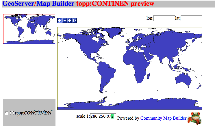
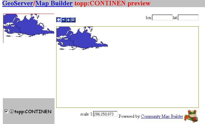
For example with basic data world (epsg 4326 & bounding box =-180;-90;9,180)
sometimes only antartic and asia are displayed
sometimes only europe and africa are displayed.
But I' m sure datas are loded coorectly because when I zoom anywhere in the
map ( and so I reduce bbox) all datas in the new bbox are displayed
correctly.
Do you think geoserver it's limited to load a certain number of polygon ?
Please help me I become crazy
Andrea Aime-3 wrote:
olivier.terral ha scritto:
Hi ,
I've a problem with oracle and geoserver.
I've a table Oracle with World map data epsg:4326 (this table has been
loaded with shp2sdo.exe and I've do everything the tutorial said
correctly)
, then I load datas in geoserver, that works good then I displays this
data in Mapbuilder that works too.
But when I want to display this data with a mercator projection,
reprojection failed .
Reprojection works for every epsg to epsg;4326 but not for every epsg
to mercator_1SP epsg (as google map);
I believe that it was because I specify epsg:4326 in Oracle table but if
I specify "null" or others for the SRID, that doesn't worked too.
These reprojections I try to make, works very good with shapefile
datastore or postgis datastore so it can't be a mapbuilder issue.
I precise that I call reprojection a GetMap request to geoserver
with an epsg who uses mercator_1SP.
So my question is :
Do you think it's a geoserver problem or an oracle problem?
Do you think it's because geom datas in the table are in lat/long?
Hmm... Oracle datastore is a can of worms, and nobody seems to have the
time to fix it. Yet, with no stack traces it's hard to tell what's going
on... It may be even data dependent. Can you give us more info?
Cheers
Andrea
-------------------------------------------------------------------------
Take Surveys. Earn Cash. Influence the Future of IT
Join SourceForge.net's Techsay panel and you'll get the chance to share
your
opinions on IT & business topics through brief surveys - and earn cash
http://www.techsay.com/default.php?page=join.php&p=sourceforge&CID=DEVDEV
_______________________________________________
Geoserver-users mailing list
Geoserver-users@lists.sourceforge.net
https://lists.sourceforge.net/lists/listinfo/geoserver-users
--
View this message in context: http://www.nabble.com/oracle-mercator-projection-tf2766770.html#a7741093
Sent from the GeoServer - User mailing list archive at Nabble.com.
Olivier Terral ha scritto:
Thanks andre to answer me
..
In fact, geoserver seems to loads data correctly so I've no log to show you
Problem, it's when I make a GetMap request, all datas doesn't displayed.
For example with basic data world (epsg 4326 & bounding box =-180;-90;9,180)
sometimes only antartic and asia are displayed sometimes only europe and africa are displayed.
But I' m sure datas are loded coorectly because when I zoom anywhere in the
map ( and so I reduce bbox) all datas in the new bbox are displayed
correctly.
Do you think geoserver it's limited to load a certain number of polygon ?
It is by default, but the number of polygons is very high (1000000 or so), so it should not be your case. Do you have any stack trace or the like? Have you tried increasing logging level and see if you can find
more info? Can you send me the data you're using?
Cheers
Andrea
Ciao Andrea,
After investigations, it seems to be a Java heap space problem that generate a strange behavior.
will have a look at it tomorow.
Cheers.
Vincent Heurteaux
Société Geomatys
vincent.heurteaux@anonymised.com
http://www.geomatys.fr
Le 7 déc. 06 à 19:27, Andrea Aime a écrit :
Olivier Terral ha scritto:
Thanks andre to answer me
…
In fact, geoserver seems to loads data correctly so I’ve no log to show you
Problem, it’s when I make a GetMap request, all datas doesn’t displayed.
For example with basic data world (epsg 4326 & bounding box =-180;-90;9,180)
sometimes only antartic and asia are displayed
sometimes only europe and africa are displayed.
But I’ m sure datas are loded coorectly because when I zoom anywhere in the
map ( and so I reduce bbox) all datas in the new bbox are displayed
correctly.
Do you think geoserver it’s limited to load a certain number of polygon ?
It is by default, but the number of polygons is very high (1000000 or
so), so it should not be your case. Do you have any stack trace or the
like? Have you tried increasing logging level and see if you can find
more info? Can you send me the data you’re using?
Cheers
Andrea
Take Surveys. Earn Cash. Influence the Future of IT
Join SourceForge.net’s Techsay panel and you’ll get the chance to share your
opinions on IT & business topics through brief surveys - and earn cash
http://www.techsay.com/default.php?page=join.php&p=sourceforge&CID=DEVDEV
Geoserver-users mailing list
Geoserver-users@lists.sourceforge.net
https://lists.sourceforge.net/lists/listinfo/geoserver-users
Vincent Heurteaux ha scritto:
Ciao Andrea,
After investigations, it seems to be a Java heap space problem that generate a strange behavior.
will have a look at it tomorow.
Ah, bigger area, more data to handle... yet, it's somewhat funny, since
the streaming renderer is specifically designed for low memory consumption. Keep me posted, I'm curious.
Cheers
Andrea
Andrea,
I think we’ve identifyed the problem.
We’re using the thrunk with gt 2.3.1 because we need WCS and our NetCDF plug-in. In this case we encourter problems when displaying the layers form Oracle (express edition).
We’ve tested Geoserver 1.4.0-RC4, and everything goes fine, so I suspect changes in gt 2.3 jars used by Oracle plug-in
Have you got any clue ?
I join screenshots from 1.4.0-RC4 and 1.5.0-BETA1
(Attachment World_1.4.0-RC4.png is missing)
(Attachment World_1.5.0_BETA1.png is missing)
Vincent Heurteaux ha scritto:
Andrea,
I think we've identifyed the problem.
We're using the thrunk with gt 2.3.1 because we need WCS and our NetCDF plug-in. In this case we encourter problems when displaying the layers form Oracle (express edition).
We've tested Geoserver 1.4.0-RC4, and everything goes fine, so I suspect changes in gt 2.3 jars used by Oracle plug-in
Have you got any clue ?
Unfortunately not. Are you sure the log, eventually set at fine or finer levels, do not give you any extra information?
Cheers
Andrea
Andrea Aime a écrit :
Vincent Heurteaux ha scritto:
Andrea,
I think we've identifyed the problem.
We're using the thrunk with gt 2.3.1 because we need WCS and our NetCDF plug-in. In this case we encourter problems when displaying the layers form Oracle (express edition).
We've tested Geoserver 1.4.0-RC4, and everything goes fine, so I suspect changes in gt 2.3 jars used by Oracle plug-in
Have you got any clue ?
Unfortunately not. Are you sure the log, eventually set at fine or finer levels, do not give you any extra information?
Cheers
Andrea
Sorry I haven't seen this part of logs 
I find an error it seems on the StreamingRenderer (with the geotools version 2.3.1).
[INFO] org.vfny.geoserver.servlets.AbstractService - handling request: org.vfny.geoserver.wms.requests.GetMapRequest@anonymised.com
java.util.logging.ErrorManager: 5
java.lang.NullPointerException
at java.io.Writer.write(Unknown Source)
at org.vfny.geoserver.global.Log4JFormatter.format(Log4JFormatter.java:158)
at java.util.logging.StreamHandler.publish(Unknown Source)
at org.vfny.geoserver.global.Log4JFormatter$Stdout.publish(Log4JFormatter.java:366)
at java.util.logging.Logger.log(Unknown Source)
at java.util.logging.Logger.doLog(Unknown Source)
at java.util.logging.Logger.log(Unknown Source)
at org.geotools.renderer.lite.StreamingRenderer.processSymbolizers(StreamingRenderer.java:1626)
at org.geotools.renderer.lite.StreamingRenderer.process(StreamingRenderer.java:1530)
at org.geotools.renderer.lite.StreamingRenderer.processStylers(StreamingRenderer.java:1472)
at org.geotools.renderer.lite.StreamingRenderer.paint(StreamingRenderer.java:687)
at org.geotools.renderer.lite.StreamingRenderer.paint(StreamingRenderer.java:430)
at org.vfny.geoserver.wms.responses.DefaultRasterMapProducer.produceMap(DefaultRasterMapProducer.java:269)
at org.vfny.geoserver.wms.responses.GetMapResponse.execute(GetMapResponse.java:308)
at org.geoserver.request.Dispatcher.dispatch(Dispatcher.java:195)
at org.geoserver.request.Dispatcher.handleRequestInternal(Dispatcher.java:58)
at org.springframework.web.servlet.mvc.AbstractController.handleRequest(AbstractController.java:139)
at org.springframework.web.servlet.mvc.SimpleControllerHandlerAdapter.handle(SimpleControllerHandlerAdapter.java:44)
at org.springframework.web.servlet.DispatcherServlet.doDispatch(DispatcherServlet.java:684)
at org.springframework.web.servlet.DispatcherServlet.doService(DispatcherServlet.java:625)
at org.springframework.web.servlet.FrameworkServlet.processRequest(FrameworkServlet.java:392)
at org.springframework.web.servlet.FrameworkServlet.doGet(FrameworkServlet.java:347)
at javax.servlet.http.HttpServlet.service(HttpServlet.java:689)
at javax.servlet.http.HttpServlet.service(HttpServlet.java:802)
at org.apache.catalina.core.ApplicationFilterChain.internalDoFilter(ApplicationFilterChain.java:252)
at org.apache.catalina.core.ApplicationFilterChain.doFilter(ApplicationFilterChain.java:173)
at org.vfny.geoserver.filters.SetCharacterEncodingFilter.doFilter(SetCharacterEncodingFilter.java:122)
at org.apache.catalina.core.ApplicationFilterChain.internalDoFilter(ApplicationFilterChain.java:202)
at org.apache.catalina.core.ApplicationFilterChain.doFilter(ApplicationFilterChain.java:173)
at org.apache.catalina.core.StandardWrapperValve.invoke(StandardWrapperValve.java:213)
at org.apache.catalina.core.StandardContextValve.invoke(StandardContextValve.java:178)
at org.apache.catalina.core.StandardHostValve.invoke(StandardHostValve.java:126)
at org.apache.catalina.valves.ErrorReportValve.invoke(ErrorReportValve.java:105)
at org.apache.catalina.core.StandardEngineValve.invoke(StandardEngineValve.java:107)
at org.apache.catalina.connector.CoyoteAdapter.service(CoyoteAdapter.java:148)
at org.apache.coyote.http11.Http11Processor.process(Http11Processor.java:869)
at org.apache.coyote.http11.Http11BaseProtocol$Http11ConnectionHandler.processConnection(Http11BaseProtocol.java:664)
at org.apache.tomcat.util.net.PoolTcpEndpoint.processSocket(PoolTcpEndpoint.java:527)
at org.apache.tomcat.util.net.LeaderFollowerWorkerThread.runIt(LeaderFollowerWorkerThread.java:80)
at org.apache.tomcat.util.threads.ThreadPool$ControlRunnable.run(ThreadPool.java:684)
at java.lang.Thread.run(Unknown Source)