Hello!
We are upgrading our Geoserver instance from version 2.11.5 to 2.14.1. As part of that task, we have been running regression tests to ensure that our data are still served and rendered as expected.
For the most part, our tests have shown no change, except for image mosaic layers stored in northern hemisphere polar stereographic projections (EPSGs 3411, 3413, 6931).
These layers show some differences in how WMS requests get rendered, leading me to wonder if there was a Geoserver code change that may have led to this observed behavior.
To be more specific:
We store thumbnail (low resolution, 300x300) images of all of our layers. When we make configuration changes, we make wms requests that we compare against those thumbnails. Any found differences get flagged for review (in this case, all of our polar stereographic north layers). When I discovered that there was a problem upgrading from Geoserver v2.11.5 to v2.14.1, I did some additional testing.
- ‘native’ resolution wms requests are consistent. In other words, if I request an image with a bounding box and size (in pixels) of the matching source data file on disk, the resulting image is the same in both v2.11.5 and v2.14.1
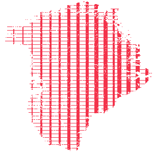
- Other WMS requests (e.g., 300x300 thumbnails, or double the native resolution), result in differences in a grid-like pattern. See the attachments vel_thumb_diff.png and conc_double_diff.png, which show the grid-like pattern of differences for two of our layers. These images were created using imagemagick’s
compareutility (each red pixel represents a difference between wms responses in v2.11.5 and v2.14.1).
All of our layers are image mosaics with the TIME dimension enabled. I tried adding a single GeoTiff from one of the affected layers as a GeoTiff store, and it did not experience this behavior. Appears as though this observed behavior only affects image mosaics.
To reproduce this issue, see the attached ‘steps_to_reproduce.txt’
Given that differences seem to only appear when an image is requested that does not match the ‘native’ resolution of the source file on disk, I suspect this might have something to do with differences in how image interpolation occurs between these versions.
GEOS-5482 (https://osgeo-org.atlassian.net/browse/GEOS-8542), which resolved an issue with polar stereographic projections may be related. I have not seen anything else obvious in the changelogs for releases since v2.11.5 which would suggest WMS rendering changes for polar stereographic projections, but I may have missed something. Does anyone know if what I am seeing is expected, or might this be a bug?
Thanks!
Trey Stafford

steps_to_reproduce.txt (1.27 KB)