Hi,
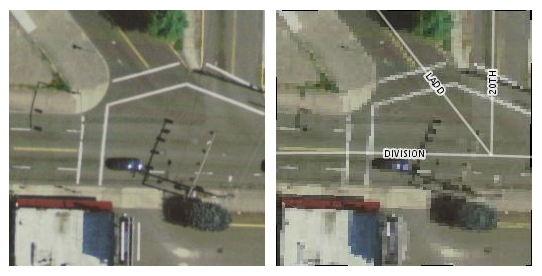
We are attempting to serve up some high-res aerial imagery (6-inch resolution JPEGs with world files) via Geoserver (1.6b1 w/ImageMosaic plugin), TileCache, and OpenLayers. Everything works but we are having a problem with the image quality (see attached jpeg, original images is on the left and Geoserver output is on the right). The images are badly pixelated and seem to be at a lower resolution than the originals. I tried adjusting the interpolation settings in the WMS rendering config settings but it made little difference. We have similar problems with 1-foot resolution images though not as severe.
I've seen this issue mentioned at least once elsewhere and was wondering if anyone had successfully resolved the problem.
Regards,
Nathan Banks
TriMet, Portland, OR
Banks, Nathan ha scritto:
Hi,
We are attempting to serve up some high-res aerial imagery (6-inch resolution JPEGs with world files) via Geoserver (1.6b1 w/ImageMosaic plugin), TileCache, and OpenLayers. Everything works but we are having a problem with the image quality (see attached jpeg, original images is on the left and Geoserver output is on the right). The images are badly pixelated and seem to be at a lower resolution than the originals. I tried adjusting the interpolation settings in the WMS rendering config settings but it made little difference. We have similar problems with 1-foot resolution images though not as severe.
I've seen this issue mentioned at least once elsewhere and was wondering if anyone had successfully resolved the problem.
I don't think it has been addressed. Can you give me a sample of that
file that I can use to figure out what's going on?
Cheers
Andrea
Banks, Nathan ha scritto:
Hi,
We are attempting to serve up some high-res aerial imagery (6-inch
resolution JPEGs with world files) via Geoserver (1.6b1 w/ImageMosaic
plugin), TileCache, and OpenLayers. Everything works but we are
having a problem with the image quality (see attached jpeg, original
images is on the left and Geoserver output is on the right). The
images are badly pixelated and seem to be at a lower resolution than
the originals. I tried adjusting the interpolation settings in the
WMS rendering config settings but it made little difference. We have
similar problems with 1-foot resolution images though not as severe.
I tried the image you sent me. With the default settings it's indeed
pixelated, but that's just because by default we don't try to fake
a resolution it's not there.
When enabling bilinear interpolation I got exactly the same results
I can get in the Windows file preview, or in a viewer such as IrfanView.
If you did not see any change, it may be because of browser caching
the tiles. I'm attaching screenshots of what I see in the Windows
image preview utility and what is generated by GeoServer with nearest neighbour and bilinear interpolation (as set in the WMS/rendering
configuration section).
Let me know if this addresses your issue.
Cheers
Andrea

All,
I think I am having the same issue.
http://www.nabble.com/geotiff's-Using-the-ImageMosaic-plugin-and-displayed-within-geoserver-appear-to-be-less-than-full-resolution-(6-inch)-to10222232.html#a14827674
see details
Is this an issue or are we doing something wrong in out configs?
Regards
Paul
aaime wrote:
Banks, Nathan ha scritto:
Hi,
We are attempting to serve up some high-res aerial imagery (6-inch
resolution JPEGs with world files) via Geoserver (1.6b1 w/ImageMosaic
plugin), TileCache, and OpenLayers. Everything works but we are having a
problem with the image quality (see attached jpeg, original images is on
the left and Geoserver output is on the right). The images are badly
pixelated and seem to be at a lower resolution than the originals. I
tried adjusting the interpolation settings in the WMS rendering config
settings but it made little difference. We have similar problems with
1-foot resolution images though not as severe.
I've seen this issue mentioned at least once elsewhere and was wondering
if anyone had successfully resolved the problem.
I don't think it has been addressed. Can you give me a sample of that
file that I can use to figure out what's going on?
Cheers
Andrea
-------------------------------------------------------------------------
This SF.net email is sponsored by: Splunk Inc.
Still grepping through log files to find problems? Stop.
Now Search log events and configuration files using AJAX and a browser.
Download your FREE copy of Splunk now >> http://get.splunk.com/
_______________________________________________
Geoserver-users mailing list
Geoserver-users@lists.sourceforge.net
https://lists.sourceforge.net/lists/listinfo/geoserver-users
http://www.nabble.com/geotiff's-Using-the-ImageMosaic-plugin-and-displayed-within-geoserver-appear-to-be-less-than-full-resolution-(6-inch)-to10222232.html#a14827674
details
--
View this message in context: http://www.nabble.com/Raster-image-quality-problem-tp13064862p14828093.html
Sent from the GeoServer - User mailing list archive at Nabble.com.
Paul McCullough ha scritto:
All,
I think I am having the same issue.
http://www.nabble.com/geotiff's-Using-the-ImageMosaic-plugin-and-displayed-within-geoserver-appear-to-be-less-than-full-resolution-(6-inch)-to10222232.html#a14827674
see details Is this an issue or are we doing something wrong in out configs?
Regards
In Nathan's case, if I remember properly, it was the projection
files that weren't set up correctly.
Anyways, if you can share at least one file of your mosaic
I can have a look.
Cheers
Andrea