Hello all,
I have problems using ImageMosaic with JPEG2000 data, on GeoServer 2.11. I have no image displayed at all in full extent of my images. Here is my configuration :
* 226 images in .jp2 (JPEG2000) on a folder, which are in 2154 projection (french proj, in meters) and resolution 0.2 meter
* mosaic_index.shp created by gdal, same folder, same projection system
* mosaic_index.properties file like this :
Levels=0.2,0.2
Name=mosaic_index
TypeName=mosaic_index
LocationAttribute=location
SuggestedSPI=com.sun.media.imageioimpl.plugins.jpeg2000.J2KImageReaderSpi
LevelsNum=1
OutputTransparentColor=#000000
When i try the OpenLayers preview of GeoServer, there is no image at all in the display...
I'm not sure i really get the "Levels" params : is it the resolution of image ? The resolution of display ? If so, which scale of resolution should i used, the one from the Tiling configs ?
Thanks a lot !
Gabriel
Gabriel,
GeoServer 2.11 is not supported, you should give 2.15.x a spin instead.
Anyways, what if you try to open a single image with the JPEG2000 reader?
If it’s not in the list of readers, then the GDAL extension needed to read it, is not installed or its native libs not properly linked.
And oh, the native libs that can read JPEG2000 fast (Kakadu) are commercial and not cheap, not sure if you accounted for that. If you cannot afford them, a one time translation to GeoTIFF might be a better fit.
Cheers
Andrea
···
Regards, Andrea Aime == GeoServer Professional Services from the experts! Visit http://goo.gl/it488V for more information. == Ing. Andrea Aime @geowolf Technical Lead GeoSolutions S.A.S. Via di Montramito 3/A 55054 Massarosa (LU) phone: +39 0584 962313 fax: +39 0584 1660272 mob: +39 339 8844549 http://www.geo-solutions.it http://twitter.com/geosolutions_it ------------------------------------------------------- Con riferimento alla normativa sul trattamento dei dati personali (Reg. UE 2016/679 - Regolamento generale sulla protezione dei dati “GDPR”), si precisa che ogni circostanza inerente alla presente email (il suo contenuto, gli eventuali allegati, etc.) è un dato la cui conoscenza è riservata al/i solo/i destinatario/i indicati dallo scrivente. Se il messaggio Le è giunto per errore, è tenuta/o a cancellarlo, ogni altra operazione è illecita. Le sarei comunque grato se potesse darmene notizia. This email is intended only for the person or entity to which it is addressed and may contain information that is privileged, confidential or otherwise protected from disclosure. We remind that - as provided by European Regulation 2016/679 “GDPR” - copying, dissemination or use of this e-mail or the information herein by anyone other than the intended recipient is prohibited. If you have received this email by mistake, please notify us immediately by telephone or e-mail.
Hi Andrea, i did a few improvements yesterday, but still with no success :
- i changed to Geoserver 2.15.1
- i installed the JP2K plugin, and i changed the .properties file with :
SuggestedSPI=it.geosolutions.imageio.plugins.jp2k.JP2KKakaduImageReaderSpi (instead of default Tiff)
ExpandToRGB=true (i don’t really know what it should be used for)
Is there any exhaustive list of the possible values for SuggestedSPI ?
The extent is well recognized, when i try with OpenLayers preview, but i have Java errors starting with :
2019-05-23 08:09:42,742 WARN [coverageio.jp2k] - Unavailable envelope for this coverage
org.geotools.data.DataSourceException: Unavailable envelope for this coverage
at org.geotools.coverageio.jp2k.JP2KReader.setCoverageProperties(JP2KReader.java:176)
at org.geotools.coverageio.jp2k.JP2KReader.(JP2KReader.java:710)
at org.geotools.coverageio.jp2k.JP2KFormat.getReader(JP2KFormat.java:111)
at org.geotools.gce.imagemosaic.GranuleDescriptor.init(GranuleDescriptor.java:385)
at org.geotools.gce.imagemosaic.GranuleDescriptor.(GranuleDescriptor.java:913)
at org.geotools.gce.imagemosaic.catalog.CachingDataStoreGranuleCatalog.getGranuleDescriptors(CachingDataStoreGranuleCatalog.java:166)
at org.geotools.gce.imagemosaic.catalog.LockingGranuleCatalog.lambda$getGranuleDescriptors$6(LockingGranuleCatalog.java:180)
at org.geotools.gce.imagemosaic.catalog.LockingGranuleCatalog.guardIO(LockingGranuleCatalog.java:93)
at org.geotools.gce.imagemosaic.catalog.LockingGranuleCatalog.getGranuleDescriptors(LockingGranuleCatalog.java:180)
at org.geotools.gce.imagemosaic.RasterManager.getGranuleDescriptors(RasterManager.java:1335)
at org.geotools.gce.imagemosaic.RasterLayerResponse.prepareResponse(RasterLayerResponse.java:668)
at org.geotools.gce.imagemosaic.RasterLayerResponse.processRequest(RasterLayerResponse.java:603)
at org.geotools.gce.imagemosaic.RasterLayerResponse.createResponse(RasterLayerResponse.java:571)
at org.geotools.gce.imagemosaic.RasterManager.read(RasterManager.java:1326)
at org.geotools.gce.imagemosaic.ImageMosaicReader.read(ImageMosaicReader.java:946)
at org.geotools.gce.imagemosaic.ImageMosaicReader.read(ImageMosaicReader.java:923)
at org.geoserver.catalog.SingleGridCoverage2DReader.read(SingleGridCoverage2DReader.java:152)
at org.geoserver.catalog.CoverageDimensionCustomizerReader.read(CoverageDimensionCustomizerReader.java:241)
at org.geoserver.catalog.CoverageDimensionCustomizerReader.read(CoverageDimensionCustomizerReader.java:229)
at org.geotools.renderer.lite.gridcoverage2d.GridCoverageReaderHelper.readSingleCoverage(GridCoverageReaderHelper.java:638)
at org.geotools.renderer.lite.gridcoverage2d.GridCoverageReaderHelper.readCoverageInEnvelope(GridCoverageReaderHelper.java:383)
at org.geotools.renderer.lite.gridcoverage2d.GridCoverageReaderHelper.readCoverages(GridCoverageReaderHelper.java:254)
at org.geotools.renderer.lite.gridcoverage2d.GridCoverageRenderer.renderImage(GridCoverageRenderer.java:880)
at org.geotools.renderer.lite.gridcoverage2d.GridCoverageRenderer.renderImage(GridCoverageRenderer.java:829)
at org.geoserver.wms.map.RenderedImageMapOutputFormat.directRasterRender(RenderedImageMapOutputFormat.java:1036)
at org.geoserver.wms.map.RenderedImageMapOutputFormat.produceMap(RenderedImageMapOutputFormat.java:349)
at org.geoserver.wms.map.RenderedImageMapOutputFormat.produceMap(RenderedImageMapOutputFormat.java:265)
at org.geoserver.wms.map.RenderedImageMapOutputFormat.produceMap(RenderedImageMapOutputFormat.java:132)
at org.geoserver.wms.GetMap.executeInternal(GetMap.java:707)
at org.geoserver.wms.GetMap.run(GetMap.java:287)
at org.geoserver.wms.GetMap.run(GetMap.java:110)
…
···
Le 22/05/2019 à 19:33, Andrea Aime a écrit :
Gabriel,
GeoServer 2.11 is not supported, you should give 2.15.x a spin instead.
Anyways, what if you try to open a single image with the JPEG2000 reader?
If it’s not in the list of readers, then the GDAL extension needed to read it, is not installed or its native libs not properly linked.
And oh, the native libs that can read JPEG2000 fast (Kakadu) are commercial and not cheap, not sure if you accounted for that. If you cannot afford them, a one time translation to GeoTIFF might be a better fit.
Cheers
Andrea
On Fri, May 17, 2019 at 11:41 AM Gabriel Vatin <gabriel.vatin@anonymised.com> wrote:
Hello all,
I have problems using ImageMosaic with JPEG2000 data, on GeoServer 2.11.
I have no image displayed at all in full extent of my images. Here is my
configuration :
- 226 images in .jp2 (JPEG2000) on a folder, which are in 2154
projection (french proj, in meters) and resolution 0.2 meter
- mosaic_index.shp created by gdal, same folder, same projection system
- mosaic_index.properties file like this :
Levels=0.2,0.2
Name=mosaic_index
TypeName=mosaic_index
LocationAttribute=location
SuggestedSPI=com.sun.media.imageioimpl.plugins.jpeg2000.J2KImageReaderSpi
LevelsNum=1
OutputTransparentColor=#000000
When i try the OpenLayers preview of GeoServer, there is no image at all
in the display…
I’m not sure i really get the “Levels” params : is it the resolution of
image ? The resolution of display ? If so, which scale of resolution
should i used, the one from the Tiling configs ?
Thanks a lot !
Gabriel
Geoserver-users mailing list
Please make sure you read the following two resources before posting to this list:
If you want to request a feature or an improvement, also see this: https://github.com/geoserver/geoserver/wiki/Successfully-requesting-and-integrating-new-features-and-improvements-in-GeoServer
Geoserver-users@lists.sourceforge.net
https://lists.sourceforge.net/lists/listinfo/geoserver-users
–
Regards, Andrea Aime == GeoServer Professional Services from the experts! Visit http://goo.gl/it488V for more information. == Ing. Andrea Aime @geowolf Technical Lead GeoSolutions S.A.S. Via di Montramito 3/A 55054 Massarosa (LU) phone: +39 0584 962313 fax: +39 0584 1660272 mob: +39 339 8844549 http://www.geo-solutions.it http://twitter.com/geosolutions_it ------------------------------------------------------- Con riferimento alla normativa sul trattamento dei dati personali (Reg. UE 2016/679 - Regolamento generale sulla protezione dei dati “GDPR”), si precisa che ogni circostanza inerente alla presente email (il suo contenuto, gli eventuali allegati, etc.) è un dato la cui conoscenza è riservata al/i solo/i destinatario/i indicati dallo scrivente. Se il messaggio Le è giunto per errore, è tenuta/o a cancellarlo, ogni altra operazione è illecita. Le sarei comunque grato se potesse darmene notizia. This email is intended only for the person or entity to which it is addressed and may contain information that is privileged, confidential or otherwise protected from disclosure. We remind that - as provided by European Regulation 2016/679 “GDPR” - copying, dissemination or use of this e-mail or the information herein by anyone other than the intended recipient is prohibited. If you have received this email by mistake, please notify us immediately by telephone or e-mail.
–

Gabriel VATIN
Docteur en Géomatique
Ingénieur de recherche
Tél : 06.63.92.94.42
Email : gabriel.vatin@anonymised.com
http://www.kinaxia.fr
“Anyways, what if you try to open a single image with the JPEG2000 reader?”
If you cannot publish a single file, there is no way that you’ll be able to put together a mosaic
Cheers
Andrea
···
Regards, Andrea Aime == GeoServer Professional Services from the experts! Visit http://goo.gl/it488V for more information. == Ing. Andrea Aime @geowolf Technical Lead GeoSolutions S.A.S. Via di Montramito 3/A 55054 Massarosa (LU) phone: +39 0584 962313 fax: +39 0584 1660272 mob: +39 339 8844549 http://www.geo-solutions.it http://twitter.com/geosolutions_it ------------------------------------------------------- Con riferimento alla normativa sul trattamento dei dati personali (Reg. UE 2016/679 - Regolamento generale sulla protezione dei dati “GDPR”), si precisa che ogni circostanza inerente alla presente email (il suo contenuto, gli eventuali allegati, etc.) è un dato la cui conoscenza è riservata al/i solo/i destinatario/i indicati dallo scrivente. Se il messaggio Le è giunto per errore, è tenuta/o a cancellarlo, ogni altra operazione è illecita. Le sarei comunque grato se potesse darmene notizia. This email is intended only for the person or entity to which it is addressed and may contain information that is privileged, confidential or otherwise protected from disclosure. We remind that - as provided by European Regulation 2016/679 “GDPR” - copying, dissemination or use of this e-mail or the information herein by anyone other than the intended recipient is prohibited. If you have received this email by mistake, please notify us immediately by telephone or e-mail.
I have the “JP2K (Direct)” option from the datastores, but from this page i cannot choose any file (no button to browse files) :
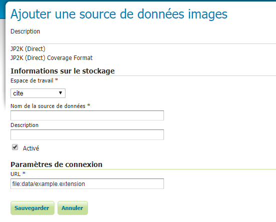
When i type the URL file:data/… to any JP2 image, then Save, i have this error on the GeoServer interface :
Could not list layers for this store, an error occurred retrieving them: Failed to create reader from file:data/jp2/06-2017-1060-6305-LA93-0M20-E080.jp2 and hints Hints: REPOSITORY = org.geoserver.catalog.CatalogRepository@anonymised.com EXECUTOR_SERVICE = java.util.concurrent.ThreadPoolExecutor@anonymised.com[Running, pool size = 0, active threads = 0, queued tasks = 0, completed tasks = 0] System defaults: LENIENT_DATUM_SHIFT = true GRID_COVERAGE_FACTORY = GridCoverageFactory TILE_ENCODING = null FORCE_AXIS_ORDER_HONORING = http FORCE_LONGITUDE_FIRST_AXIS_ORDER = true STYLE_FACTORY = StyleFactoryImpl FEATURE_FACTORY = org.geotools.feature.LenientFeatureFactoryImpl@anonymised.com COMPARISON_TOLERANCE = 1.0E-8 FILTER_FACTORY = FilterFactoryImpl
And this on the logs :
WARN [coverageio.jp2k] - Unavailable envelope for this coverage
org.geotools.data.DataSourceException: Unavailable envelope for this coverage
at org.geotools.coverageio.jp2k.JP2KReader.setCoverageProperties(JP2KReader.java:176)
at org.geotools.coverageio.jp2k.JP2KReader.(JP2KReader.java:710)
at org.geotools.coverageio.jp2k.JP2KFormat.getReader(JP2KFormat.java:111)
at org.geoserver.catalog.ResourcePool.getGridCoverageReader(ResourcePool.java:1490)
at org.geoserver.catalog.ResourcePool.getGridCoverageReader(ResourcePool.java:1436)
at org.geoserver.catalog.impl.CoverageStoreInfoImpl.getGridCoverageReader(CoverageStoreInfoImpl.java:53)
at sun.reflect.NativeMethodAccessorImpl.invoke0(Native Method)
at sun.reflect.NativeMethodAccessorImpl.invoke(NativeMethodAccessorImpl.java:62)
at sun.reflect.DelegatingMethodAccessorImpl.invoke(DelegatingMethodAccessorImpl.java:43)
at java.lang.reflect.Method.invoke(Method.java:498)
at org.geoserver.catalog.impl.ModificationProxy.invoke(ModificationProxy.java:127)
at com.sun.proxy.$Proxy24.getGridCoverageReader(Unknown Source)
at org.geoserver.web.data.layer.NewLayerPageProvider.getItemsInternal(NewLayerPageProvider.java:86)
···
Le 23/05/2019 à 08:16, Andrea Aime a écrit :
“Anyways, what if you try to open a single image with the JPEG2000 reader?”
If you cannot publish a single file, there is no way that you’ll be able to put together a mosaic
Cheers
Andrea
On Thu, May 23, 2019 at 8:13 AM Gabriel Vatin <gabriel.vatin@anonymised.com> wrote:
Hi Andrea, i did a few improvements yesterday, but still with no success :
- i changed to Geoserver 2.15.1
- i installed the JP2K plugin, and i changed the .properties file with :
SuggestedSPI=it.geosolutions.imageio.plugins.jp2k.JP2KKakaduImageReaderSpi (instead of default Tiff)
ExpandToRGB=true (i don’t really know what it should be used for)
Is there any exhaustive list of the possible values for SuggestedSPI ?
The extent is well recognized, when i try with OpenLayers preview, but i have Java errors starting with :
2019-05-23 08:09:42,742 WARN [coverageio.jp2k] - Unavailable envelope for this coverage
org.geotools.data.DataSourceException: Unavailable envelope for this coverage
at org.geotools.coverageio.jp2k.JP2KReader.setCoverageProperties(JP2KReader.java:176)
at org.geotools.coverageio.jp2k.JP2KReader.(JP2KReader.java:710)
at org.geotools.coverageio.jp2k.JP2KFormat.getReader(JP2KFormat.java:111)
at org.geotools.gce.imagemosaic.GranuleDescriptor.init(GranuleDescriptor.java:385)
at org.geotools.gce.imagemosaic.GranuleDescriptor.(GranuleDescriptor.java:913)
at org.geotools.gce.imagemosaic.catalog.CachingDataStoreGranuleCatalog.getGranuleDescriptors(CachingDataStoreGranuleCatalog.java:166)
at org.geotools.gce.imagemosaic.catalog.LockingGranuleCatalog.lambda$getGranuleDescriptors$6(LockingGranuleCatalog.java:180)
at org.geotools.gce.imagemosaic.catalog.LockingGranuleCatalog.guardIO(LockingGranuleCatalog.java:93)
at org.geotools.gce.imagemosaic.catalog.LockingGranuleCatalog.getGranuleDescriptors(LockingGranuleCatalog.java:180)
at org.geotools.gce.imagemosaic.RasterManager.getGranuleDescriptors(RasterManager.java:1335)
at org.geotools.gce.imagemosaic.RasterLayerResponse.prepareResponse(RasterLayerResponse.java:668)
at org.geotools.gce.imagemosaic.RasterLayerResponse.processRequest(RasterLayerResponse.java:603)
at org.geotools.gce.imagemosaic.RasterLayerResponse.createResponse(RasterLayerResponse.java:571)
at org.geotools.gce.imagemosaic.RasterManager.read(RasterManager.java:1326)
at org.geotools.gce.imagemosaic.ImageMosaicReader.read(ImageMosaicReader.java:946)
at org.geotools.gce.imagemosaic.ImageMosaicReader.read(ImageMosaicReader.java:923)
at org.geoserver.catalog.SingleGridCoverage2DReader.read(SingleGridCoverage2DReader.java:152)
at org.geoserver.catalog.CoverageDimensionCustomizerReader.read(CoverageDimensionCustomizerReader.java:241)
at org.geoserver.catalog.CoverageDimensionCustomizerReader.read(CoverageDimensionCustomizerReader.java:229)
at org.geotools.renderer.lite.gridcoverage2d.GridCoverageReaderHelper.readSingleCoverage(GridCoverageReaderHelper.java:638)
at org.geotools.renderer.lite.gridcoverage2d.GridCoverageReaderHelper.readCoverageInEnvelope(GridCoverageReaderHelper.java:383)
at org.geotools.renderer.lite.gridcoverage2d.GridCoverageReaderHelper.readCoverages(GridCoverageReaderHelper.java:254)
at org.geotools.renderer.lite.gridcoverage2d.GridCoverageRenderer.renderImage(GridCoverageRenderer.java:880)
at org.geotools.renderer.lite.gridcoverage2d.GridCoverageRenderer.renderImage(GridCoverageRenderer.java:829)
at org.geoserver.wms.map.RenderedImageMapOutputFormat.directRasterRender(RenderedImageMapOutputFormat.java:1036)
at org.geoserver.wms.map.RenderedImageMapOutputFormat.produceMap(RenderedImageMapOutputFormat.java:349)
at org.geoserver.wms.map.RenderedImageMapOutputFormat.produceMap(RenderedImageMapOutputFormat.java:265)
at org.geoserver.wms.map.RenderedImageMapOutputFormat.produceMap(RenderedImageMapOutputFormat.java:132)
at org.geoserver.wms.GetMap.executeInternal(GetMap.java:707)
at org.geoserver.wms.GetMap.run(GetMap.java:287)
at org.geoserver.wms.GetMap.run(GetMap.java:110)
…
Le 22/05/2019 à 19:33, Andrea Aime a écrit :
Gabriel,
GeoServer 2.11 is not supported, you should give 2.15.x a spin instead.
Anyways, what if you try to open a single image with the JPEG2000 reader?
If it’s not in the list of readers, then the GDAL extension needed to read it, is not installed or its native libs not properly linked.
And oh, the native libs that can read JPEG2000 fast (Kakadu) are commercial and not cheap, not sure if you accounted for that. If you cannot afford them, a one time translation to GeoTIFF might be a better fit.
Cheers
Andrea
On Fri, May 17, 2019 at 11:41 AM Gabriel Vatin <gabriel.vatin@anonymised.com> wrote:
Hello all,
I have problems using ImageMosaic with JPEG2000 data, on GeoServer 2.11.
I have no image displayed at all in full extent of my images. Here is my
configuration :
- 226 images in .jp2 (JPEG2000) on a folder, which are in 2154
projection (french proj, in meters) and resolution 0.2 meter
- mosaic_index.shp created by gdal, same folder, same projection system
- mosaic_index.properties file like this :
Levels=0.2,0.2
Name=mosaic_index
TypeName=mosaic_index
LocationAttribute=location
SuggestedSPI=com.sun.media.imageioimpl.plugins.jpeg2000.J2KImageReaderSpi
LevelsNum=1
OutputTransparentColor=#000000
When i try the OpenLayers preview of GeoServer, there is no image at all
in the display…
I’m not sure i really get the “Levels” params : is it the resolution of
image ? The resolution of display ? If so, which scale of resolution
should i used, the one from the Tiling configs ?
Thanks a lot !
Gabriel
Geoserver-users mailing list
Please make sure you read the following two resources before posting to this list:
If you want to request a feature or an improvement, also see this: https://github.com/geoserver/geoserver/wiki/Successfully-requesting-and-integrating-new-features-and-improvements-in-GeoServer
Geoserver-users@lists.sourceforge.net
https://lists.sourceforge.net/lists/listinfo/geoserver-users
–
Regards, Andrea Aime == GeoServer Professional Services from the experts! Visit http://goo.gl/it488V for more information. == Ing. Andrea Aime @geowolf Technical Lead GeoSolutions S.A.S. Via di Montramito 3/A 55054 Massarosa (LU) phone: +39 0584 962313 fax: +39 0584 1660272 mob: +39 339 8844549 http://www.geo-solutions.it http://twitter.com/geosolutions_it ------------------------------------------------------- Con riferimento alla normativa sul trattamento dei dati personali (Reg. UE 2016/679 - Regolamento generale sulla protezione dei dati “GDPR”), si precisa che ogni circostanza inerente alla presente email (il suo contenuto, gli eventuali allegati, etc.) è un dato la cui conoscenza è riservata al/i solo/i destinatario/i indicati dallo scrivente. Se il messaggio Le è giunto per errore, è tenuta/o a cancellarlo, ogni altra operazione è illecita. Le sarei comunque grato se potesse darmene notizia. This email is intended only for the person or entity to which it is addressed and may contain information that is privileged, confidential or otherwise protected from disclosure. We remind that - as provided by European Regulation 2016/679 “GDPR” - copying, dissemination or use of this e-mail or the information herein by anyone other than the intended recipient is prohibited. If you have received this email by mistake, please notify us immediately by telephone or e-mail.
–
Gabriel VATIN
Docteur en Géomatique
Ingénieur de recherche
Tél : 06.63.92.94.42
Email : gabriel.vatin@anonymised.com
http://www.kinaxia.fr
–
Regards, Andrea Aime == GeoServer Professional Services from the experts! Visit http://goo.gl/it488V for more information. == Ing. Andrea Aime @geowolf Technical Lead GeoSolutions S.A.S. Via di Montramito 3/A 55054 Massarosa (LU) phone: +39 0584 962313 fax: +39 0584 1660272 mob: +39 339 8844549 http://www.geo-solutions.it http://twitter.com/geosolutions_it ------------------------------------------------------- Con riferimento alla normativa sul trattamento dei dati personali (Reg. UE 2016/679 - Regolamento generale sulla protezione dei dati “GDPR”), si precisa che ogni circostanza inerente alla presente email (il suo contenuto, gli eventuali allegati, etc.) è un dato la cui conoscenza è riservata al/i solo/i destinatario/i indicati dallo scrivente. Se il messaggio Le è giunto per errore, è tenuta/o a cancellarlo, ogni altra operazione è illecita. Le sarei comunque grato se potesse darmene notizia. This email is intended only for the person or entity to which it is addressed and may contain information that is privileged, confidential or otherwise protected from disclosure. We remind that - as provided by European Regulation 2016/679 “GDPR” - copying, dissemination or use of this e-mail or the information herein by anyone other than the intended recipient is prohibited. If you have received this email by mistake, please notify us immediately by telephone or e-mail.
–
Gabriel VATIN
Docteur en Géomatique
Ingénieur de recherche
Tél : 06.63.92.94.42
Email : gabriel.vatin@anonymised.com
http://www.kinaxia.fr
In case, here is the gdalinfo of my test single image:
Driver: JP2OpenJPEG/JPEG-2000 driver based on OpenJPEG library
Files: C:\Program Files (x86)\GeoServer 2.15.1\data_dir\data\jp2\06-2017-1060-6305-LA93-0M20-E080.jp2
Size is 25000, 25000
Coordinate System is:
PROJCS[“RGF93 / Lambert-93”,
(…)
Band 1 Block=1024x1024 Type=Byte, ColorInterp=Red
Overviews: 12500x12500, 6250x6250, 3125x3125, 1562x1562, 781x781, 390x390, 195x195, 97x97
Overviews: arbitrary
Image Structure Metadata:
COMPRESSION=JPEG2000
Band 2 Block=1024x1024 Type=Byte, ColorInterp=Green
Overviews: 12500x12500, 6250x6250, 3125x3125, 1562x1562, 781x781, 390x390, 195x195, 97x97
Overviews: arbitrary
Image Structure Metadata:
COMPRESSION=JPEG2000
Band 3 Block=1024x1024 Type=Byte, ColorInterp=Blue
Overviews: 12500x12500, 6250x6250, 3125x3125, 1562x1562, 781x781, 390x390, 195x195, 97x97
Overviews: arbitrary
Image Structure Metadata:
COMPRESSION=JPEG2000
···
Le 23/05/2019 à 08:16, Andrea Aime a écrit :
“Anyways, what if you try to open a single image with the JPEG2000 reader?”
If you cannot publish a single file, there is no way that you’ll be able to put together a mosaic
Cheers
Andrea
On Thu, May 23, 2019 at 8:13 AM Gabriel Vatin <gabriel.vatin@anonymised.com> wrote:
Hi Andrea, i did a few improvements yesterday, but still with no success :
- i changed to Geoserver 2.15.1
- i installed the JP2K plugin, and i changed the .properties file with :
SuggestedSPI=it.geosolutions.imageio.plugins.jp2k.JP2KKakaduImageReaderSpi (instead of default Tiff)
ExpandToRGB=true (i don’t really know what it should be used for)
Is there any exhaustive list of the possible values for SuggestedSPI ?
The extent is well recognized, when i try with OpenLayers preview, but i have Java errors starting with :
2019-05-23 08:09:42,742 WARN [coverageio.jp2k] - Unavailable envelope for this coverage
org.geotools.data.DataSourceException: Unavailable envelope for this coverage
at org.geotools.coverageio.jp2k.JP2KReader.setCoverageProperties(JP2KReader.java:176)
at org.geotools.coverageio.jp2k.JP2KReader.(JP2KReader.java:710)
at org.geotools.coverageio.jp2k.JP2KFormat.getReader(JP2KFormat.java:111)
at org.geotools.gce.imagemosaic.GranuleDescriptor.init(GranuleDescriptor.java:385)
at org.geotools.gce.imagemosaic.GranuleDescriptor.(GranuleDescriptor.java:913)
at org.geotools.gce.imagemosaic.catalog.CachingDataStoreGranuleCatalog.getGranuleDescriptors(CachingDataStoreGranuleCatalog.java:166)
at org.geotools.gce.imagemosaic.catalog.LockingGranuleCatalog.lambda$getGranuleDescriptors$6(LockingGranuleCatalog.java:180)
at org.geotools.gce.imagemosaic.catalog.LockingGranuleCatalog.guardIO(LockingGranuleCatalog.java:93)
at org.geotools.gce.imagemosaic.catalog.LockingGranuleCatalog.getGranuleDescriptors(LockingGranuleCatalog.java:180)
at org.geotools.gce.imagemosaic.RasterManager.getGranuleDescriptors(RasterManager.java:1335)
at org.geotools.gce.imagemosaic.RasterLayerResponse.prepareResponse(RasterLayerResponse.java:668)
at org.geotools.gce.imagemosaic.RasterLayerResponse.processRequest(RasterLayerResponse.java:603)
at org.geotools.gce.imagemosaic.RasterLayerResponse.createResponse(RasterLayerResponse.java:571)
at org.geotools.gce.imagemosaic.RasterManager.read(RasterManager.java:1326)
at org.geotools.gce.imagemosaic.ImageMosaicReader.read(ImageMosaicReader.java:946)
at org.geotools.gce.imagemosaic.ImageMosaicReader.read(ImageMosaicReader.java:923)
at org.geoserver.catalog.SingleGridCoverage2DReader.read(SingleGridCoverage2DReader.java:152)
at org.geoserver.catalog.CoverageDimensionCustomizerReader.read(CoverageDimensionCustomizerReader.java:241)
at org.geoserver.catalog.CoverageDimensionCustomizerReader.read(CoverageDimensionCustomizerReader.java:229)
at org.geotools.renderer.lite.gridcoverage2d.GridCoverageReaderHelper.readSingleCoverage(GridCoverageReaderHelper.java:638)
at org.geotools.renderer.lite.gridcoverage2d.GridCoverageReaderHelper.readCoverageInEnvelope(GridCoverageReaderHelper.java:383)
at org.geotools.renderer.lite.gridcoverage2d.GridCoverageReaderHelper.readCoverages(GridCoverageReaderHelper.java:254)
at org.geotools.renderer.lite.gridcoverage2d.GridCoverageRenderer.renderImage(GridCoverageRenderer.java:880)
at org.geotools.renderer.lite.gridcoverage2d.GridCoverageRenderer.renderImage(GridCoverageRenderer.java:829)
at org.geoserver.wms.map.RenderedImageMapOutputFormat.directRasterRender(RenderedImageMapOutputFormat.java:1036)
at org.geoserver.wms.map.RenderedImageMapOutputFormat.produceMap(RenderedImageMapOutputFormat.java:349)
at org.geoserver.wms.map.RenderedImageMapOutputFormat.produceMap(RenderedImageMapOutputFormat.java:265)
at org.geoserver.wms.map.RenderedImageMapOutputFormat.produceMap(RenderedImageMapOutputFormat.java:132)
at org.geoserver.wms.GetMap.executeInternal(GetMap.java:707)
at org.geoserver.wms.GetMap.run(GetMap.java:287)
at org.geoserver.wms.GetMap.run(GetMap.java:110)
…
Le 22/05/2019 à 19:33, Andrea Aime a écrit :
Gabriel,
GeoServer 2.11 is not supported, you should give 2.15.x a spin instead.
Anyways, what if you try to open a single image with the JPEG2000 reader?
If it’s not in the list of readers, then the GDAL extension needed to read it, is not installed or its native libs not properly linked.
And oh, the native libs that can read JPEG2000 fast (Kakadu) are commercial and not cheap, not sure if you accounted for that. If you cannot afford them, a one time translation to GeoTIFF might be a better fit.
Cheers
Andrea
On Fri, May 17, 2019 at 11:41 AM Gabriel Vatin <gabriel.vatin@anonymised.com> wrote:
Hello all,
I have problems using ImageMosaic with JPEG2000 data, on GeoServer 2.11.
I have no image displayed at all in full extent of my images. Here is my
configuration :
- 226 images in .jp2 (JPEG2000) on a folder, which are in 2154
projection (french proj, in meters) and resolution 0.2 meter
- mosaic_index.shp created by gdal, same folder, same projection system
- mosaic_index.properties file like this :
Levels=0.2,0.2
Name=mosaic_index
TypeName=mosaic_index
LocationAttribute=location
SuggestedSPI=com.sun.media.imageioimpl.plugins.jpeg2000.J2KImageReaderSpi
LevelsNum=1
OutputTransparentColor=#000000
When i try the OpenLayers preview of GeoServer, there is no image at all
in the display…
I’m not sure i really get the “Levels” params : is it the resolution of
image ? The resolution of display ? If so, which scale of resolution
should i used, the one from the Tiling configs ?
Thanks a lot !
Gabriel
Geoserver-users mailing list
Please make sure you read the following two resources before posting to this list:
If you want to request a feature or an improvement, also see this: https://github.com/geoserver/geoserver/wiki/Successfully-requesting-and-integrating-new-features-and-improvements-in-GeoServer
Geoserver-users@lists.sourceforge.net
https://lists.sourceforge.net/lists/listinfo/geoserver-users
–
Regards, Andrea Aime == GeoServer Professional Services from the experts! Visit http://goo.gl/it488V for more information. == Ing. Andrea Aime @geowolf Technical Lead GeoSolutions S.A.S. Via di Montramito 3/A 55054 Massarosa (LU) phone: +39 0584 962313 fax: +39 0584 1660272 mob: +39 339 8844549 http://www.geo-solutions.it http://twitter.com/geosolutions_it ------------------------------------------------------- Con riferimento alla normativa sul trattamento dei dati personali (Reg. UE 2016/679 - Regolamento generale sulla protezione dei dati “GDPR”), si precisa che ogni circostanza inerente alla presente email (il suo contenuto, gli eventuali allegati, etc.) è un dato la cui conoscenza è riservata al/i solo/i destinatario/i indicati dallo scrivente. Se il messaggio Le è giunto per errore, è tenuta/o a cancellarlo, ogni altra operazione è illecita. Le sarei comunque grato se potesse darmene notizia. This email is intended only for the person or entity to which it is addressed and may contain information that is privileged, confidential or otherwise protected from disclosure. We remind that - as provided by European Regulation 2016/679 “GDPR” - copying, dissemination or use of this e-mail or the information herein by anyone other than the intended recipient is prohibited. If you have received this email by mistake, please notify us immediately by telephone or e-mail.
–
Gabriel VATIN
Docteur en Géomatique
Ingénieur de recherche
Tél : 06.63.92.94.42
Email : gabriel.vatin@anonymised.com
http://www.kinaxia.fr
–
Regards, Andrea Aime == GeoServer Professional Services from the experts! Visit http://goo.gl/it488V for more information. == Ing. Andrea Aime @geowolf Technical Lead GeoSolutions S.A.S. Via di Montramito 3/A 55054 Massarosa (LU) phone: +39 0584 962313 fax: +39 0584 1660272 mob: +39 339 8844549 http://www.geo-solutions.it http://twitter.com/geosolutions_it ------------------------------------------------------- Con riferimento alla normativa sul trattamento dei dati personali (Reg. UE 2016/679 - Regolamento generale sulla protezione dei dati “GDPR”), si precisa che ogni circostanza inerente alla presente email (il suo contenuto, gli eventuali allegati, etc.) è un dato la cui conoscenza è riservata al/i solo/i destinatario/i indicati dallo scrivente. Se il messaggio Le è giunto per errore, è tenuta/o a cancellarlo, ogni altra operazione è illecita. Le sarei comunque grato se potesse darmene notizia. This email is intended only for the person or entity to which it is addressed and may contain information that is privileged, confidential or otherwise protected from disclosure. We remind that - as provided by European Regulation 2016/679 “GDPR” - copying, dissemination or use of this e-mail or the information herein by anyone other than the intended recipient is prohibited. If you have received this email by mistake, please notify us immediately by telephone or e-mail.
–
Gabriel VATIN
Docteur en Géomatique
Ingénieur de recherche
Tél : 06.63.92.94.42
Email : gabriel.vatin@anonymised.com
http://www.kinaxia.fr
Hi,
I’m not very familiar with the JP2K reader code, but it seems it’s trying to fetch the raster
bounding box in a variety of ways and they all fail:
https://github.com/geotools/geotools/blob/a1e08cc358f38dc22bf4f896abdd2bc7569f6f7f/modules/plugin/jp2k/src/main/java/org/geotools/coverageio/jp2k/JP2KReader.java#L157
I’m guessing the raster is either missing the information, or provides it in a way that’s not supported.
You can probably make it work by adding a world file on the side, same file name as the jp2, but
extension either j2w or wld.
Also, if you can share the file, open a ticket on Jira with the stack trace you shared and
attach a sample file
Cheers
Andrea
···
Regards, Andrea Aime == GeoServer Professional Services from the experts! Visit http://goo.gl/it488V for more information. == Ing. Andrea Aime @geowolf Technical Lead GeoSolutions S.A.S. Via di Montramito 3/A 55054 Massarosa (LU) phone: +39 0584 962313 fax: +39 0584 1660272 mob: +39 339 8844549 http://www.geo-solutions.it http://twitter.com/geosolutions_it ------------------------------------------------------- Con riferimento alla normativa sul trattamento dei dati personali (Reg. UE 2016/679 - Regolamento generale sulla protezione dei dati “GDPR”), si precisa che ogni circostanza inerente alla presente email (il suo contenuto, gli eventuali allegati, etc.) è un dato la cui conoscenza è riservata al/i solo/i destinatario/i indicati dallo scrivente. Se il messaggio Le è giunto per errore, è tenuta/o a cancellarlo, ogni altra operazione è illecita. Le sarei comunque grato se potesse darmene notizia. This email is intended only for the person or entity to which it is addressed and may contain information that is privileged, confidential or otherwise protected from disclosure. We remind that - as provided by European Regulation 2016/679 “GDPR” - copying, dissemination or use of this e-mail or the information herein by anyone other than the intended recipient is prohibited. If you have received this email by mistake, please notify us immediately by telephone or e-mail.
Ok i will try this World File solution. I have the GeoServer plugins GDAL and JP2K from the plugins page of GS.
About the metadata file, i have currently .tab files, one for each .jp2 file. Its structure is :
!table
!version 300
!charset WindowsLatin1
Definition Table
File “06-2017-1060-6305-LA93-0M20-E080.jp2”
Type “RASTER”
(1060000.00,6305000.00) (0,0) Label “Pt 1”,
(1065000.00,6305000.00) (25000,0) Label “Pt 2”,
(1065000.00,6300000.00) (25000,25000) Label “Pt 3”,
(1060000.00,6300000.00) (0,25000) Label “Pt 4”
CoordSys Earth Projection 2003, 33, 7, 3, 46.5, 44, 49.00000000001, 700000, 6600000, -792421, 5278231, 3520778, 9741029
Units “m”
···
Le 23/05/2019 à 08:40, Andrea Aime a écrit :
Hi,
I’m not very familiar with the JP2K reader code, but it seems it’s trying to fetch the raster
bounding box in a variety of ways and they all fail:
https://github.com/geotools/geotools/blob/a1e08cc358f38dc22bf4f896abdd2bc7569f6f7f/modules/plugin/jp2k/src/main/java/org/geotools/coverageio/jp2k/JP2KReader.java#L157
I’m guessing the raster is either missing the information, or provides it in a way that’s not supported.
You can probably make it work by adding a world file on the side, same file name as the jp2, but
extension either j2w or wld.
Also, if you can share the file, open a ticket on Jira with the stack trace you shared and
attach a sample file
Cheers
Andrea
On Thu, May 23, 2019 at 8:25 AM Gabriel Vatin <gabriel.vatin@anonymised.com> wrote:
I have the “JP2K (Direct)” option from the datastores, but from this page i cannot choose any file (no button to browse files) :
![]()
When i type the URL file:data/… to any JP2 image, then Save, i have this error on the GeoServer interface :
Could not list layers for this store, an error occurred retrieving them: Failed to create reader from file:data/jp2/06-2017-1060-6305-LA93-0M20-E080.jp2 and hints Hints: REPOSITORY = org.geoserver.catalog.CatalogRepository@anonymised.com EXECUTOR_SERVICE = java.util.concurrent.ThreadPoolExecutor@anonymised.com[Running, pool size = 0, active threads = 0, queued tasks = 0, completed tasks = 0] System defaults: LENIENT_DATUM_SHIFT = true GRID_COVERAGE_FACTORY = GridCoverageFactory TILE_ENCODING = null FORCE_AXIS_ORDER_HONORING = http FORCE_LONGITUDE_FIRST_AXIS_ORDER = true STYLE_FACTORY = StyleFactoryImpl FEATURE_FACTORY = org.geotools.feature.LenientFeatureFactoryImpl@anonymised.com COMPARISON_TOLERANCE = 1.0E-8 FILTER_FACTORY = FilterFactoryImpl
And this on the logs :
WARN [coverageio.jp2k] - Unavailable envelope for this coverage
org.geotools.data.DataSourceException: Unavailable envelope for this coverage
at org.geotools.coverageio.jp2k.JP2KReader.setCoverageProperties(JP2KReader.java:176)
at org.geotools.coverageio.jp2k.JP2KReader.(JP2KReader.java:710)
at org.geotools.coverageio.jp2k.JP2KFormat.getReader(JP2KFormat.java:111)
at org.geoserver.catalog.ResourcePool.getGridCoverageReader(ResourcePool.java:1490)
at org.geoserver.catalog.ResourcePool.getGridCoverageReader(ResourcePool.java:1436)
at org.geoserver.catalog.impl.CoverageStoreInfoImpl.getGridCoverageReader(CoverageStoreInfoImpl.java:53)
at sun.reflect.NativeMethodAccessorImpl.invoke0(Native Method)
at sun.reflect.NativeMethodAccessorImpl.invoke(NativeMethodAccessorImpl.java:62)
at sun.reflect.DelegatingMethodAccessorImpl.invoke(DelegatingMethodAccessorImpl.java:43)
at java.lang.reflect.Method.invoke(Method.java:498)
at org.geoserver.catalog.impl.ModificationProxy.invoke(ModificationProxy.java:127)
at com.sun.proxy.$Proxy24.getGridCoverageReader(Unknown Source)
at org.geoserver.web.data.layer.NewLayerPageProvider.getItemsInternal(NewLayerPageProvider.java:86)
Le 23/05/2019 à 08:16, Andrea Aime a écrit :
“Anyways, what if you try to open a single image with the JPEG2000 reader?”
If you cannot publish a single file, there is no way that you’ll be able to put together a mosaic
Cheers
Andrea
On Thu, May 23, 2019 at 8:13 AM Gabriel Vatin <gabriel.vatin@anonymised.com> wrote:
Hi Andrea, i did a few improvements yesterday, but still with no success :
- i changed to Geoserver 2.15.1
- i installed the JP2K plugin, and i changed the .properties file with :
SuggestedSPI=it.geosolutions.imageio.plugins.jp2k.JP2KKakaduImageReaderSpi (instead of default Tiff)
ExpandToRGB=true (i don’t really know what it should be used for)
Is there any exhaustive list of the possible values for SuggestedSPI ?
The extent is well recognized, when i try with OpenLayers preview, but i have Java errors starting with :
2019-05-23 08:09:42,742 WARN [coverageio.jp2k] - Unavailable envelope for this coverage
org.geotools.data.DataSourceException: Unavailable envelope for this coverage
at org.geotools.coverageio.jp2k.JP2KReader.setCoverageProperties(JP2KReader.java:176)
at org.geotools.coverageio.jp2k.JP2KReader.(JP2KReader.java:710)
at org.geotools.coverageio.jp2k.JP2KFormat.getReader(JP2KFormat.java:111)
at org.geotools.gce.imagemosaic.GranuleDescriptor.init(GranuleDescriptor.java:385)
at org.geotools.gce.imagemosaic.GranuleDescriptor.(GranuleDescriptor.java:913)
at org.geotools.gce.imagemosaic.catalog.CachingDataStoreGranuleCatalog.getGranuleDescriptors(CachingDataStoreGranuleCatalog.java:166)
at org.geotools.gce.imagemosaic.catalog.LockingGranuleCatalog.lambda$getGranuleDescriptors$6(LockingGranuleCatalog.java:180)
at org.geotools.gce.imagemosaic.catalog.LockingGranuleCatalog.guardIO(LockingGranuleCatalog.java:93)
at org.geotools.gce.imagemosaic.catalog.LockingGranuleCatalog.getGranuleDescriptors(LockingGranuleCatalog.java:180)
at org.geotools.gce.imagemosaic.RasterManager.getGranuleDescriptors(RasterManager.java:1335)
at org.geotools.gce.imagemosaic.RasterLayerResponse.prepareResponse(RasterLayerResponse.java:668)
at org.geotools.gce.imagemosaic.RasterLayerResponse.processRequest(RasterLayerResponse.java:603)
at org.geotools.gce.imagemosaic.RasterLayerResponse.createResponse(RasterLayerResponse.java:571)
at org.geotools.gce.imagemosaic.RasterManager.read(RasterManager.java:1326)
at org.geotools.gce.imagemosaic.ImageMosaicReader.read(ImageMosaicReader.java:946)
at org.geotools.gce.imagemosaic.ImageMosaicReader.read(ImageMosaicReader.java:923)
at org.geoserver.catalog.SingleGridCoverage2DReader.read(SingleGridCoverage2DReader.java:152)
at org.geoserver.catalog.CoverageDimensionCustomizerReader.read(CoverageDimensionCustomizerReader.java:241)
at org.geoserver.catalog.CoverageDimensionCustomizerReader.read(CoverageDimensionCustomizerReader.java:229)
at org.geotools.renderer.lite.gridcoverage2d.GridCoverageReaderHelper.readSingleCoverage(GridCoverageReaderHelper.java:638)
at org.geotools.renderer.lite.gridcoverage2d.GridCoverageReaderHelper.readCoverageInEnvelope(GridCoverageReaderHelper.java:383)
at org.geotools.renderer.lite.gridcoverage2d.GridCoverageReaderHelper.readCoverages(GridCoverageReaderHelper.java:254)
at org.geotools.renderer.lite.gridcoverage2d.GridCoverageRenderer.renderImage(GridCoverageRenderer.java:880)
at org.geotools.renderer.lite.gridcoverage2d.GridCoverageRenderer.renderImage(GridCoverageRenderer.java:829)
at org.geoserver.wms.map.RenderedImageMapOutputFormat.directRasterRender(RenderedImageMapOutputFormat.java:1036)
at org.geoserver.wms.map.RenderedImageMapOutputFormat.produceMap(RenderedImageMapOutputFormat.java:349)
at org.geoserver.wms.map.RenderedImageMapOutputFormat.produceMap(RenderedImageMapOutputFormat.java:265)
at org.geoserver.wms.map.RenderedImageMapOutputFormat.produceMap(RenderedImageMapOutputFormat.java:132)
at org.geoserver.wms.GetMap.executeInternal(GetMap.java:707)
at org.geoserver.wms.GetMap.run(GetMap.java:287)
at org.geoserver.wms.GetMap.run(GetMap.java:110)
…
Le 22/05/2019 à 19:33, Andrea Aime a écrit :
Gabriel,
GeoServer 2.11 is not supported, you should give 2.15.x a spin instead.
Anyways, what if you try to open a single image with the JPEG2000 reader?
If it’s not in the list of readers, then the GDAL extension needed to read it, is not installed or its native libs not properly linked.
And oh, the native libs that can read JPEG2000 fast (Kakadu) are commercial and not cheap, not sure if you accounted for that. If you cannot afford them, a one time translation to GeoTIFF might be a better fit.
Cheers
Andrea
On Fri, May 17, 2019 at 11:41 AM Gabriel Vatin <gabriel.vatin@anonymised.com> wrote:
Hello all,
I have problems using ImageMosaic with JPEG2000 data, on GeoServer 2.11.
I have no image displayed at all in full extent of my images. Here is my
configuration :
- 226 images in .jp2 (JPEG2000) on a folder, which are in 2154
projection (french proj, in meters) and resolution 0.2 meter
- mosaic_index.shp created by gdal, same folder, same projection system
- mosaic_index.properties file like this :
Levels=0.2,0.2
Name=mosaic_index
TypeName=mosaic_index
LocationAttribute=location
SuggestedSPI=com.sun.media.imageioimpl.plugins.jpeg2000.J2KImageReaderSpi
LevelsNum=1
OutputTransparentColor=#000000
When i try the OpenLayers preview of GeoServer, there is no image at all
in the display…
I’m not sure i really get the “Levels” params : is it the resolution of
image ? The resolution of display ? If so, which scale of resolution
should i used, the one from the Tiling configs ?
Thanks a lot !
Gabriel
Geoserver-users mailing list
Please make sure you read the following two resources before posting to this list:
If you want to request a feature or an improvement, also see this: https://github.com/geoserver/geoserver/wiki/Successfully-requesting-and-integrating-new-features-and-improvements-in-GeoServer
Geoserver-users@lists.sourceforge.net
https://lists.sourceforge.net/lists/listinfo/geoserver-users
–
Regards, Andrea Aime == GeoServer Professional Services from the experts! Visit http://goo.gl/it488V for more information. == Ing. Andrea Aime @geowolf Technical Lead GeoSolutions S.A.S. Via di Montramito 3/A 55054 Massarosa (LU) phone: +39 0584 962313 fax: +39 0584 1660272 mob: +39 339 8844549 http://www.geo-solutions.it http://twitter.com/geosolutions_it ------------------------------------------------------- Con riferimento alla normativa sul trattamento dei dati personali (Reg. UE 2016/679 - Regolamento generale sulla protezione dei dati “GDPR”), si precisa che ogni circostanza inerente alla presente email (il suo contenuto, gli eventuali allegati, etc.) è un dato la cui conoscenza è riservata al/i solo/i destinatario/i indicati dallo scrivente. Se il messaggio Le è giunto per errore, è tenuta/o a cancellarlo, ogni altra operazione è illecita. Le sarei comunque grato se potesse darmene notizia. This email is intended only for the person or entity to which it is addressed and may contain information that is privileged, confidential or otherwise protected from disclosure. We remind that - as provided by European Regulation 2016/679 “GDPR” - copying, dissemination or use of this e-mail or the information herein by anyone other than the intended recipient is prohibited. If you have received this email by mistake, please notify us immediately by telephone or e-mail.
–
Gabriel VATIN
Docteur en Géomatique
Ingénieur de recherche
Tél : 06.63.92.94.42
Email : gabriel.vatin@anonymised.com
http://www.kinaxia.fr
–
Regards, Andrea Aime == GeoServer Professional Services from the experts! Visit http://goo.gl/it488V for more information. == Ing. Andrea Aime @geowolf Technical Lead GeoSolutions S.A.S. Via di Montramito 3/A 55054 Massarosa (LU) phone: +39 0584 962313 fax: +39 0584 1660272 mob: +39 339 8844549 http://www.geo-solutions.it http://twitter.com/geosolutions_it ------------------------------------------------------- Con riferimento alla normativa sul trattamento dei dati personali (Reg. UE 2016/679 - Regolamento generale sulla protezione dei dati “GDPR”), si precisa che ogni circostanza inerente alla presente email (il suo contenuto, gli eventuali allegati, etc.) è un dato la cui conoscenza è riservata al/i solo/i destinatario/i indicati dallo scrivente. Se il messaggio Le è giunto per errore, è tenuta/o a cancellarlo, ogni altra operazione è illecita. Le sarei comunque grato se potesse darmene notizia. This email is intended only for the person or entity to which it is addressed and may contain information that is privileged, confidential or otherwise protected from disclosure. We remind that - as provided by European Regulation 2016/679 “GDPR” - copying, dissemination or use of this e-mail or the information herein by anyone other than the intended recipient is prohibited. If you have received this email by mistake, please notify us immediately by telephone or e-mail.
–
Gabriel VATIN
Docteur en Géomatique
Ingénieur de recherche
Tél : 06.63.92.94.42
Email : gabriel.vatin@anonymised.com
http://www.kinaxia.fr
–
Regards, Andrea Aime == GeoServer Professional Services from the experts! Visit http://goo.gl/it488V for more information. == Ing. Andrea Aime @geowolf Technical Lead GeoSolutions S.A.S. Via di Montramito 3/A 55054 Massarosa (LU) phone: +39 0584 962313 fax: +39 0584 1660272 mob: +39 339 8844549 http://www.geo-solutions.it http://twitter.com/geosolutions_it ------------------------------------------------------- Con riferimento alla normativa sul trattamento dei dati personali (Reg. UE 2016/679 - Regolamento generale sulla protezione dei dati “GDPR”), si precisa che ogni circostanza inerente alla presente email (il suo contenuto, gli eventuali allegati, etc.) è un dato la cui conoscenza è riservata al/i solo/i destinatario/i indicati dallo scrivente. Se il messaggio Le è giunto per errore, è tenuta/o a cancellarlo, ogni altra operazione è illecita. Le sarei comunque grato se potesse darmene notizia. This email is intended only for the person or entity to which it is addressed and may contain information that is privileged, confidential or otherwise protected from disclosure. We remind that - as provided by European Regulation 2016/679 “GDPR” - copying, dissemination or use of this e-mail or the information herein by anyone other than the intended recipient is prohibited. If you have received this email by mistake, please notify us immediately by telephone or e-mail.
–
Gabriel VATIN
Docteur en Géomatique
Ingénieur de recherche
Tél : 06.63.92.94.42
Email : gabriel.vatin@anonymised.com
http://www.kinaxia.fr
I did the J2W WorldFile, now i got this error :
Could not list layers for this store, an error occurred retrieving them: null
[geoserver.web] - Getting list of coverages for saved store file:data/jp2/06-2017-1060-6305-LA93-0M20-E080.jp2
java.lang.RuntimeException: Could not list layers for this store, an error occurred retrieving them: null
at org.geoserver.web.data.layer.NewLayerPageProvider.getItemsInternal(NewLayerPageProvider.java:170)
at org.geoserver.web.data.layer.NewLayerPageProvider.getItems(NewLayerPageProvider.java:47)
at org.geoserver.web.wicket.GeoServerDataProvider.getFilteredItems(GeoServerDataProvider.java:202)
···
Le 23/05/2019 à 08:40, Andrea Aime a écrit :
Hi,
I’m not very familiar with the JP2K reader code, but it seems it’s trying to fetch the raster
bounding box in a variety of ways and they all fail:
https://github.com/geotools/geotools/blob/a1e08cc358f38dc22bf4f896abdd2bc7569f6f7f/modules/plugin/jp2k/src/main/java/org/geotools/coverageio/jp2k/JP2KReader.java#L157
I’m guessing the raster is either missing the information, or provides it in a way that’s not supported.
You can probably make it work by adding a world file on the side, same file name as the jp2, but
extension either j2w or wld.
Also, if you can share the file, open a ticket on Jira with the stack trace you shared and
attach a sample file
Cheers
Andrea
On Thu, May 23, 2019 at 8:25 AM Gabriel Vatin <gabriel.vatin@anonymised.com> wrote:
I have the “JP2K (Direct)” option from the datastores, but from this page i cannot choose any file (no button to browse files) :
![]()
When i type the URL file:data/… to any JP2 image, then Save, i have this error on the GeoServer interface :
Could not list layers for this store, an error occurred retrieving them: Failed to create reader from file:data/jp2/06-2017-1060-6305-LA93-0M20-E080.jp2 and hints Hints: REPOSITORY = org.geoserver.catalog.CatalogRepository@anonymised.com EXECUTOR_SERVICE = java.util.concurrent.ThreadPoolExecutor@anonymised.com[Running, pool size = 0, active threads = 0, queued tasks = 0, completed tasks = 0] System defaults: LENIENT_DATUM_SHIFT = true GRID_COVERAGE_FACTORY = GridCoverageFactory TILE_ENCODING = null FORCE_AXIS_ORDER_HONORING = http FORCE_LONGITUDE_FIRST_AXIS_ORDER = true STYLE_FACTORY = StyleFactoryImpl FEATURE_FACTORY = org.geotools.feature.LenientFeatureFactoryImpl@anonymised.com COMPARISON_TOLERANCE = 1.0E-8 FILTER_FACTORY = FilterFactoryImpl
And this on the logs :
WARN [coverageio.jp2k] - Unavailable envelope for this coverage
org.geotools.data.DataSourceException: Unavailable envelope for this coverage
at org.geotools.coverageio.jp2k.JP2KReader.setCoverageProperties(JP2KReader.java:176)
at org.geotools.coverageio.jp2k.JP2KReader.(JP2KReader.java:710)
at org.geotools.coverageio.jp2k.JP2KFormat.getReader(JP2KFormat.java:111)
at org.geoserver.catalog.ResourcePool.getGridCoverageReader(ResourcePool.java:1490)
at org.geoserver.catalog.ResourcePool.getGridCoverageReader(ResourcePool.java:1436)
at org.geoserver.catalog.impl.CoverageStoreInfoImpl.getGridCoverageReader(CoverageStoreInfoImpl.java:53)
at sun.reflect.NativeMethodAccessorImpl.invoke0(Native Method)
at sun.reflect.NativeMethodAccessorImpl.invoke(NativeMethodAccessorImpl.java:62)
at sun.reflect.DelegatingMethodAccessorImpl.invoke(DelegatingMethodAccessorImpl.java:43)
at java.lang.reflect.Method.invoke(Method.java:498)
at org.geoserver.catalog.impl.ModificationProxy.invoke(ModificationProxy.java:127)
at com.sun.proxy.$Proxy24.getGridCoverageReader(Unknown Source)
at org.geoserver.web.data.layer.NewLayerPageProvider.getItemsInternal(NewLayerPageProvider.java:86)
Le 23/05/2019 à 08:16, Andrea Aime a écrit :
“Anyways, what if you try to open a single image with the JPEG2000 reader?”
If you cannot publish a single file, there is no way that you’ll be able to put together a mosaic
Cheers
Andrea
On Thu, May 23, 2019 at 8:13 AM Gabriel Vatin <gabriel.vatin@anonymised.com> wrote:
Hi Andrea, i did a few improvements yesterday, but still with no success :
- i changed to Geoserver 2.15.1
- i installed the JP2K plugin, and i changed the .properties file with :
SuggestedSPI=it.geosolutions.imageio.plugins.jp2k.JP2KKakaduImageReaderSpi (instead of default Tiff)
ExpandToRGB=true (i don’t really know what it should be used for)
Is there any exhaustive list of the possible values for SuggestedSPI ?
The extent is well recognized, when i try with OpenLayers preview, but i have Java errors starting with :
2019-05-23 08:09:42,742 WARN [coverageio.jp2k] - Unavailable envelope for this coverage
org.geotools.data.DataSourceException: Unavailable envelope for this coverage
at org.geotools.coverageio.jp2k.JP2KReader.setCoverageProperties(JP2KReader.java:176)
at org.geotools.coverageio.jp2k.JP2KReader.(JP2KReader.java:710)
at org.geotools.coverageio.jp2k.JP2KFormat.getReader(JP2KFormat.java:111)
at org.geotools.gce.imagemosaic.GranuleDescriptor.init(GranuleDescriptor.java:385)
at org.geotools.gce.imagemosaic.GranuleDescriptor.(GranuleDescriptor.java:913)
at org.geotools.gce.imagemosaic.catalog.CachingDataStoreGranuleCatalog.getGranuleDescriptors(CachingDataStoreGranuleCatalog.java:166)
at org.geotools.gce.imagemosaic.catalog.LockingGranuleCatalog.lambda$getGranuleDescriptors$6(LockingGranuleCatalog.java:180)
at org.geotools.gce.imagemosaic.catalog.LockingGranuleCatalog.guardIO(LockingGranuleCatalog.java:93)
at org.geotools.gce.imagemosaic.catalog.LockingGranuleCatalog.getGranuleDescriptors(LockingGranuleCatalog.java:180)
at org.geotools.gce.imagemosaic.RasterManager.getGranuleDescriptors(RasterManager.java:1335)
at org.geotools.gce.imagemosaic.RasterLayerResponse.prepareResponse(RasterLayerResponse.java:668)
at org.geotools.gce.imagemosaic.RasterLayerResponse.processRequest(RasterLayerResponse.java:603)
at org.geotools.gce.imagemosaic.RasterLayerResponse.createResponse(RasterLayerResponse.java:571)
at org.geotools.gce.imagemosaic.RasterManager.read(RasterManager.java:1326)
at org.geotools.gce.imagemosaic.ImageMosaicReader.read(ImageMosaicReader.java:946)
at org.geotools.gce.imagemosaic.ImageMosaicReader.read(ImageMosaicReader.java:923)
at org.geoserver.catalog.SingleGridCoverage2DReader.read(SingleGridCoverage2DReader.java:152)
at org.geoserver.catalog.CoverageDimensionCustomizerReader.read(CoverageDimensionCustomizerReader.java:241)
at org.geoserver.catalog.CoverageDimensionCustomizerReader.read(CoverageDimensionCustomizerReader.java:229)
at org.geotools.renderer.lite.gridcoverage2d.GridCoverageReaderHelper.readSingleCoverage(GridCoverageReaderHelper.java:638)
at org.geotools.renderer.lite.gridcoverage2d.GridCoverageReaderHelper.readCoverageInEnvelope(GridCoverageReaderHelper.java:383)
at org.geotools.renderer.lite.gridcoverage2d.GridCoverageReaderHelper.readCoverages(GridCoverageReaderHelper.java:254)
at org.geotools.renderer.lite.gridcoverage2d.GridCoverageRenderer.renderImage(GridCoverageRenderer.java:880)
at org.geotools.renderer.lite.gridcoverage2d.GridCoverageRenderer.renderImage(GridCoverageRenderer.java:829)
at org.geoserver.wms.map.RenderedImageMapOutputFormat.directRasterRender(RenderedImageMapOutputFormat.java:1036)
at org.geoserver.wms.map.RenderedImageMapOutputFormat.produceMap(RenderedImageMapOutputFormat.java:349)
at org.geoserver.wms.map.RenderedImageMapOutputFormat.produceMap(RenderedImageMapOutputFormat.java:265)
at org.geoserver.wms.map.RenderedImageMapOutputFormat.produceMap(RenderedImageMapOutputFormat.java:132)
at org.geoserver.wms.GetMap.executeInternal(GetMap.java:707)
at org.geoserver.wms.GetMap.run(GetMap.java:287)
at org.geoserver.wms.GetMap.run(GetMap.java:110)
…
Le 22/05/2019 à 19:33, Andrea Aime a écrit :
Gabriel,
GeoServer 2.11 is not supported, you should give 2.15.x a spin instead.
Anyways, what if you try to open a single image with the JPEG2000 reader?
If it’s not in the list of readers, then the GDAL extension needed to read it, is not installed or its native libs not properly linked.
And oh, the native libs that can read JPEG2000 fast (Kakadu) are commercial and not cheap, not sure if you accounted for that. If you cannot afford them, a one time translation to GeoTIFF might be a better fit.
Cheers
Andrea
On Fri, May 17, 2019 at 11:41 AM Gabriel Vatin <gabriel.vatin@anonymised.com> wrote:
Hello all,
I have problems using ImageMosaic with JPEG2000 data, on GeoServer 2.11.
I have no image displayed at all in full extent of my images. Here is my
configuration :
- 226 images in .jp2 (JPEG2000) on a folder, which are in 2154
projection (french proj, in meters) and resolution 0.2 meter
- mosaic_index.shp created by gdal, same folder, same projection system
- mosaic_index.properties file like this :
Levels=0.2,0.2
Name=mosaic_index
TypeName=mosaic_index
LocationAttribute=location
SuggestedSPI=com.sun.media.imageioimpl.plugins.jpeg2000.J2KImageReaderSpi
LevelsNum=1
OutputTransparentColor=#000000
When i try the OpenLayers preview of GeoServer, there is no image at all
in the display…
I’m not sure i really get the “Levels” params : is it the resolution of
image ? The resolution of display ? If so, which scale of resolution
should i used, the one from the Tiling configs ?
Thanks a lot !
Gabriel
Geoserver-users mailing list
Please make sure you read the following two resources before posting to this list:
If you want to request a feature or an improvement, also see this: https://github.com/geoserver/geoserver/wiki/Successfully-requesting-and-integrating-new-features-and-improvements-in-GeoServer
Geoserver-users@lists.sourceforge.net
https://lists.sourceforge.net/lists/listinfo/geoserver-users
–
Regards, Andrea Aime == GeoServer Professional Services from the experts! Visit http://goo.gl/it488V for more information. == Ing. Andrea Aime @geowolf Technical Lead GeoSolutions S.A.S. Via di Montramito 3/A 55054 Massarosa (LU) phone: +39 0584 962313 fax: +39 0584 1660272 mob: +39 339 8844549 http://www.geo-solutions.it http://twitter.com/geosolutions_it ------------------------------------------------------- Con riferimento alla normativa sul trattamento dei dati personali (Reg. UE 2016/679 - Regolamento generale sulla protezione dei dati “GDPR”), si precisa che ogni circostanza inerente alla presente email (il suo contenuto, gli eventuali allegati, etc.) è un dato la cui conoscenza è riservata al/i solo/i destinatario/i indicati dallo scrivente. Se il messaggio Le è giunto per errore, è tenuta/o a cancellarlo, ogni altra operazione è illecita. Le sarei comunque grato se potesse darmene notizia. This email is intended only for the person or entity to which it is addressed and may contain information that is privileged, confidential or otherwise protected from disclosure. We remind that - as provided by European Regulation 2016/679 “GDPR” - copying, dissemination or use of this e-mail or the information herein by anyone other than the intended recipient is prohibited. If you have received this email by mistake, please notify us immediately by telephone or e-mail.
–
Gabriel VATIN
Docteur en Géomatique
Ingénieur de recherche
Tél : 06.63.92.94.42
Email : gabriel.vatin@anonymised.com
http://www.kinaxia.fr
–
Regards, Andrea Aime == GeoServer Professional Services from the experts! Visit http://goo.gl/it488V for more information. == Ing. Andrea Aime @geowolf Technical Lead GeoSolutions S.A.S. Via di Montramito 3/A 55054 Massarosa (LU) phone: +39 0584 962313 fax: +39 0584 1660272 mob: +39 339 8844549 http://www.geo-solutions.it http://twitter.com/geosolutions_it ------------------------------------------------------- Con riferimento alla normativa sul trattamento dei dati personali (Reg. UE 2016/679 - Regolamento generale sulla protezione dei dati “GDPR”), si precisa che ogni circostanza inerente alla presente email (il suo contenuto, gli eventuali allegati, etc.) è un dato la cui conoscenza è riservata al/i solo/i destinatario/i indicati dallo scrivente. Se il messaggio Le è giunto per errore, è tenuta/o a cancellarlo, ogni altra operazione è illecita. Le sarei comunque grato se potesse darmene notizia. This email is intended only for the person or entity to which it is addressed and may contain information that is privileged, confidential or otherwise protected from disclosure. We remind that - as provided by European Regulation 2016/679 “GDPR” - copying, dissemination or use of this e-mail or the information herein by anyone other than the intended recipient is prohibited. If you have received this email by mistake, please notify us immediately by telephone or e-mail.
–
Gabriel VATIN
Docteur en Géomatique
Ingénieur de recherche
Tél : 06.63.92.94.42
Email : gabriel.vatin@anonymised.com
http://www.kinaxia.fr
–
Regards, Andrea Aime == GeoServer Professional Services from the experts! Visit http://goo.gl/it488V for more information. == Ing. Andrea Aime @geowolf Technical Lead GeoSolutions S.A.S. Via di Montramito 3/A 55054 Massarosa (LU) phone: +39 0584 962313 fax: +39 0584 1660272 mob: +39 339 8844549 http://www.geo-solutions.it http://twitter.com/geosolutions_it ------------------------------------------------------- Con riferimento alla normativa sul trattamento dei dati personali (Reg. UE 2016/679 - Regolamento generale sulla protezione dei dati “GDPR”), si precisa che ogni circostanza inerente alla presente email (il suo contenuto, gli eventuali allegati, etc.) è un dato la cui conoscenza è riservata al/i solo/i destinatario/i indicati dallo scrivente. Se il messaggio Le è giunto per errore, è tenuta/o a cancellarlo, ogni altra operazione è illecita. Le sarei comunque grato se potesse darmene notizia. This email is intended only for the person or entity to which it is addressed and may contain information that is privileged, confidential or otherwise protected from disclosure. We remind that - as provided by European Regulation 2016/679 “GDPR” - copying, dissemination or use of this e-mail or the information herein by anyone other than the intended recipient is prohibited. If you have received this email by mistake, please notify us immediately by telephone or e-mail.
–
Gabriel VATIN
Docteur en Géomatique
Ingénieur de recherche
Tél : 06.63.92.94.42
Email : gabriel.vatin@anonymised.com
http://www.kinaxia.fr
Sorry, can’t help you any further, please open a ticket and wait for someone to look at it, and/or consider getting commercial support:
http://geoserver.org/comm/
Cheers
Andrea
···
Regards, Andrea Aime == GeoServer Professional Services from the experts! Visit http://goo.gl/it488V for more information. == Ing. Andrea Aime @geowolf Technical Lead GeoSolutions S.A.S. Via di Montramito 3/A 55054 Massarosa (LU) phone: +39 0584 962313 fax: +39 0584 1660272 mob: +39 339 8844549 http://www.geo-solutions.it http://twitter.com/geosolutions_it ------------------------------------------------------- Con riferimento alla normativa sul trattamento dei dati personali (Reg. UE 2016/679 - Regolamento generale sulla protezione dei dati “GDPR”), si precisa che ogni circostanza inerente alla presente email (il suo contenuto, gli eventuali allegati, etc.) è un dato la cui conoscenza è riservata al/i solo/i destinatario/i indicati dallo scrivente. Se il messaggio Le è giunto per errore, è tenuta/o a cancellarlo, ogni altra operazione è illecita. Le sarei comunque grato se potesse darmene notizia. This email is intended only for the person or entity to which it is addressed and may contain information that is privileged, confidential or otherwise protected from disclosure. We remind that - as provided by European Regulation 2016/679 “GDPR” - copying, dissemination or use of this e-mail or the information herein by anyone other than the intended recipient is prohibited. If you have received this email by mistake, please notify us immediately by telephone or e-mail.
Thanks Andrea, i opened a Jira : https://osgeo-org.atlassian.net/projects/GEOS/issues/GEOS-9225
Gabriel
···
Le 23/05/2019 à 09:06, Andrea Aime a écrit :
Sorry, can’t help you any further, please open a ticket and wait for someone to look at it, and/or consider getting commercial support:
http://geoserver.org/comm/
Cheers
Andrea
On Thu, May 23, 2019 at 9:03 AM Gabriel Vatin <gabriel.vatin@anonymised.com> wrote:
I did the J2W WorldFile, now i got this error :
Could not list layers for this store, an error occurred retrieving them: null
[geoserver.web] - Getting list of coverages for saved store file:data/jp2/06-2017-1060-6305-LA93-0M20-E080.jp2
java.lang.RuntimeException: Could not list layers for this store, an error occurred retrieving them: null
at org.geoserver.web.data.layer.NewLayerPageProvider.getItemsInternal(NewLayerPageProvider.java:170)
at org.geoserver.web.data.layer.NewLayerPageProvider.getItems(NewLayerPageProvider.java:47)
at org.geoserver.web.wicket.GeoServerDataProvider.getFilteredItems(GeoServerDataProvider.java:202)
Le 23/05/2019 à 08:40, Andrea Aime a écrit :
Hi,
I’m not very familiar with the JP2K reader code, but it seems it’s trying to fetch the raster
bounding box in a variety of ways and they all fail:
https://github.com/geotools/geotools/blob/a1e08cc358f38dc22bf4f896abdd2bc7569f6f7f/modules/plugin/jp2k/src/main/java/org/geotools/coverageio/jp2k/JP2KReader.java#L157
I’m guessing the raster is either missing the information, or provides it in a way that’s not supported.
You can probably make it work by adding a world file on the side, same file name as the jp2, but
extension either j2w or wld.
Also, if you can share the file, open a ticket on Jira with the stack trace you shared and
attach a sample file
Cheers
Andrea
On Thu, May 23, 2019 at 8:25 AM Gabriel Vatin <gabriel.vatin@anonymised.com> wrote:
I have the “JP2K (Direct)” option from the datastores, but from this page i cannot choose any file (no button to browse files) :
![]()
When i type the URL file:data/… to any JP2 image, then Save, i have this error on the GeoServer interface :
Could not list layers for this store, an error occurred retrieving them: Failed to create reader from file:data/jp2/06-2017-1060-6305-LA93-0M20-E080.jp2 and hints Hints: REPOSITORY = org.geoserver.catalog.CatalogRepository@anonymised.com EXECUTOR_SERVICE = java.util.concurrent.ThreadPoolExecutor@anonymised.com[Running, pool size = 0, active threads = 0, queued tasks = 0, completed tasks = 0] System defaults: LENIENT_DATUM_SHIFT = true GRID_COVERAGE_FACTORY = GridCoverageFactory TILE_ENCODING = null FORCE_AXIS_ORDER_HONORING = http FORCE_LONGITUDE_FIRST_AXIS_ORDER = true STYLE_FACTORY = StyleFactoryImpl FEATURE_FACTORY = org.geotools.feature.LenientFeatureFactoryImpl@anonymised.com COMPARISON_TOLERANCE = 1.0E-8 FILTER_FACTORY = FilterFactoryImpl
And this on the logs :
WARN [coverageio.jp2k] - Unavailable envelope for this coverage
org.geotools.data.DataSourceException: Unavailable envelope for this coverage
at org.geotools.coverageio.jp2k.JP2KReader.setCoverageProperties(JP2KReader.java:176)
at org.geotools.coverageio.jp2k.JP2KReader.(JP2KReader.java:710)
at org.geotools.coverageio.jp2k.JP2KFormat.getReader(JP2KFormat.java:111)
at org.geoserver.catalog.ResourcePool.getGridCoverageReader(ResourcePool.java:1490)
at org.geoserver.catalog.ResourcePool.getGridCoverageReader(ResourcePool.java:1436)
at org.geoserver.catalog.impl.CoverageStoreInfoImpl.getGridCoverageReader(CoverageStoreInfoImpl.java:53)
at sun.reflect.NativeMethodAccessorImpl.invoke0(Native Method)
at sun.reflect.NativeMethodAccessorImpl.invoke(NativeMethodAccessorImpl.java:62)
at sun.reflect.DelegatingMethodAccessorImpl.invoke(DelegatingMethodAccessorImpl.java:43)
at java.lang.reflect.Method.invoke(Method.java:498)
at org.geoserver.catalog.impl.ModificationProxy.invoke(ModificationProxy.java:127)
at com.sun.proxy.$Proxy24.getGridCoverageReader(Unknown Source)
at org.geoserver.web.data.layer.NewLayerPageProvider.getItemsInternal(NewLayerPageProvider.java:86)
Le 23/05/2019 à 08:16, Andrea Aime a écrit :
“Anyways, what if you try to open a single image with the JPEG2000 reader?”
If you cannot publish a single file, there is no way that you’ll be able to put together a mosaic
Cheers
Andrea
On Thu, May 23, 2019 at 8:13 AM Gabriel Vatin <gabriel.vatin@anonymised.com> wrote:
Hi Andrea, i did a few improvements yesterday, but still with no success :
- i changed to Geoserver 2.15.1
- i installed the JP2K plugin, and i changed the .properties file with :
SuggestedSPI=it.geosolutions.imageio.plugins.jp2k.JP2KKakaduImageReaderSpi (instead of default Tiff)
ExpandToRGB=true (i don’t really know what it should be used for)
Is there any exhaustive list of the possible values for SuggestedSPI ?
The extent is well recognized, when i try with OpenLayers preview, but i have Java errors starting with :
2019-05-23 08:09:42,742 WARN [coverageio.jp2k] - Unavailable envelope for this coverage
org.geotools.data.DataSourceException: Unavailable envelope for this coverage
at org.geotools.coverageio.jp2k.JP2KReader.setCoverageProperties(JP2KReader.java:176)
at org.geotools.coverageio.jp2k.JP2KReader.(JP2KReader.java:710)
at org.geotools.coverageio.jp2k.JP2KFormat.getReader(JP2KFormat.java:111)
at org.geotools.gce.imagemosaic.GranuleDescriptor.init(GranuleDescriptor.java:385)
at org.geotools.gce.imagemosaic.GranuleDescriptor.(GranuleDescriptor.java:913)
at org.geotools.gce.imagemosaic.catalog.CachingDataStoreGranuleCatalog.getGranuleDescriptors(CachingDataStoreGranuleCatalog.java:166)
at org.geotools.gce.imagemosaic.catalog.LockingGranuleCatalog.lambda$getGranuleDescriptors$6(LockingGranuleCatalog.java:180)
at org.geotools.gce.imagemosaic.catalog.LockingGranuleCatalog.guardIO(LockingGranuleCatalog.java:93)
at org.geotools.gce.imagemosaic.catalog.LockingGranuleCatalog.getGranuleDescriptors(LockingGranuleCatalog.java:180)
at org.geotools.gce.imagemosaic.RasterManager.getGranuleDescriptors(RasterManager.java:1335)
at org.geotools.gce.imagemosaic.RasterLayerResponse.prepareResponse(RasterLayerResponse.java:668)
at org.geotools.gce.imagemosaic.RasterLayerResponse.processRequest(RasterLayerResponse.java:603)
at org.geotools.gce.imagemosaic.RasterLayerResponse.createResponse(RasterLayerResponse.java:571)
at org.geotools.gce.imagemosaic.RasterManager.read(RasterManager.java:1326)
at org.geotools.gce.imagemosaic.ImageMosaicReader.read(ImageMosaicReader.java:946)
at org.geotools.gce.imagemosaic.ImageMosaicReader.read(ImageMosaicReader.java:923)
at org.geoserver.catalog.SingleGridCoverage2DReader.read(SingleGridCoverage2DReader.java:152)
at org.geoserver.catalog.CoverageDimensionCustomizerReader.read(CoverageDimensionCustomizerReader.java:241)
at org.geoserver.catalog.CoverageDimensionCustomizerReader.read(CoverageDimensionCustomizerReader.java:229)
at org.geotools.renderer.lite.gridcoverage2d.GridCoverageReaderHelper.readSingleCoverage(GridCoverageReaderHelper.java:638)
at org.geotools.renderer.lite.gridcoverage2d.GridCoverageReaderHelper.readCoverageInEnvelope(GridCoverageReaderHelper.java:383)
at org.geotools.renderer.lite.gridcoverage2d.GridCoverageReaderHelper.readCoverages(GridCoverageReaderHelper.java:254)
at org.geotools.renderer.lite.gridcoverage2d.GridCoverageRenderer.renderImage(GridCoverageRenderer.java:880)
at org.geotools.renderer.lite.gridcoverage2d.GridCoverageRenderer.renderImage(GridCoverageRenderer.java:829)
at org.geoserver.wms.map.RenderedImageMapOutputFormat.directRasterRender(RenderedImageMapOutputFormat.java:1036)
at org.geoserver.wms.map.RenderedImageMapOutputFormat.produceMap(RenderedImageMapOutputFormat.java:349)
at org.geoserver.wms.map.RenderedImageMapOutputFormat.produceMap(RenderedImageMapOutputFormat.java:265)
at org.geoserver.wms.map.RenderedImageMapOutputFormat.produceMap(RenderedImageMapOutputFormat.java:132)
at org.geoserver.wms.GetMap.executeInternal(GetMap.java:707)
at org.geoserver.wms.GetMap.run(GetMap.java:287)
at org.geoserver.wms.GetMap.run(GetMap.java:110)
…
Le 22/05/2019 à 19:33, Andrea Aime a écrit :
Gabriel,
GeoServer 2.11 is not supported, you should give 2.15.x a spin instead.
Anyways, what if you try to open a single image with the JPEG2000 reader?
If it’s not in the list of readers, then the GDAL extension needed to read it, is not installed or its native libs not properly linked.
And oh, the native libs that can read JPEG2000 fast (Kakadu) are commercial and not cheap, not sure if you accounted for that. If you cannot afford them, a one time translation to GeoTIFF might be a better fit.
Cheers
Andrea
On Fri, May 17, 2019 at 11:41 AM Gabriel Vatin <gabriel.vatin@anonymised.com> wrote:
Hello all,
I have problems using ImageMosaic with JPEG2000 data, on GeoServer 2.11.
I have no image displayed at all in full extent of my images. Here is my
configuration :
- 226 images in .jp2 (JPEG2000) on a folder, which are in 2154
projection (french proj, in meters) and resolution 0.2 meter
- mosaic_index.shp created by gdal, same folder, same projection system
- mosaic_index.properties file like this :
Levels=0.2,0.2
Name=mosaic_index
TypeName=mosaic_index
LocationAttribute=location
SuggestedSPI=com.sun.media.imageioimpl.plugins.jpeg2000.J2KImageReaderSpi
LevelsNum=1
OutputTransparentColor=#000000
When i try the OpenLayers preview of GeoServer, there is no image at all
in the display…
I’m not sure i really get the “Levels” params : is it the resolution of
image ? The resolution of display ? If so, which scale of resolution
should i used, the one from the Tiling configs ?
Thanks a lot !
Gabriel
Geoserver-users mailing list
Please make sure you read the following two resources before posting to this list:
If you want to request a feature or an improvement, also see this: https://github.com/geoserver/geoserver/wiki/Successfully-requesting-and-integrating-new-features-and-improvements-in-GeoServer
Geoserver-users@lists.sourceforge.net
https://lists.sourceforge.net/lists/listinfo/geoserver-users
–
Regards, Andrea Aime == GeoServer Professional Services from the experts! Visit http://goo.gl/it488V for more information. == Ing. Andrea Aime @geowolf Technical Lead GeoSolutions S.A.S. Via di Montramito 3/A 55054 Massarosa (LU) phone: +39 0584 962313 fax: +39 0584 1660272 mob: +39 339 8844549 http://www.geo-solutions.it http://twitter.com/geosolutions_it ------------------------------------------------------- Con riferimento alla normativa sul trattamento dei dati personali (Reg. UE 2016/679 - Regolamento generale sulla protezione dei dati “GDPR”), si precisa che ogni circostanza inerente alla presente email (il suo contenuto, gli eventuali allegati, etc.) è un dato la cui conoscenza è riservata al/i solo/i destinatario/i indicati dallo scrivente. Se il messaggio Le è giunto per errore, è tenuta/o a cancellarlo, ogni altra operazione è illecita. Le sarei comunque grato se potesse darmene notizia. This email is intended only for the person or entity to which it is addressed and may contain information that is privileged, confidential or otherwise protected from disclosure. We remind that - as provided by European Regulation 2016/679 “GDPR” - copying, dissemination or use of this e-mail or the information herein by anyone other than the intended recipient is prohibited. If you have received this email by mistake, please notify us immediately by telephone or e-mail.
–
Gabriel VATIN
Docteur en Géomatique
Ingénieur de recherche
Tél : 06.63.92.94.42
Email : gabriel.vatin@anonymised.com
http://www.kinaxia.fr
–
Regards, Andrea Aime == GeoServer Professional Services from the experts! Visit http://goo.gl/it488V for more information. == Ing. Andrea Aime @geowolf Technical Lead GeoSolutions S.A.S. Via di Montramito 3/A 55054 Massarosa (LU) phone: +39 0584 962313 fax: +39 0584 1660272 mob: +39 339 8844549 http://www.geo-solutions.it http://twitter.com/geosolutions_it ------------------------------------------------------- Con riferimento alla normativa sul trattamento dei dati personali (Reg. UE 2016/679 - Regolamento generale sulla protezione dei dati “GDPR”), si precisa che ogni circostanza inerente alla presente email (il suo contenuto, gli eventuali allegati, etc.) è un dato la cui conoscenza è riservata al/i solo/i destinatario/i indicati dallo scrivente. Se il messaggio Le è giunto per errore, è tenuta/o a cancellarlo, ogni altra operazione è illecita. Le sarei comunque grato se potesse darmene notizia. This email is intended only for the person or entity to which it is addressed and may contain information that is privileged, confidential or otherwise protected from disclosure. We remind that - as provided by European Regulation 2016/679 “GDPR” - copying, dissemination or use of this e-mail or the information herein by anyone other than the intended recipient is prohibited. If you have received this email by mistake, please notify us immediately by telephone or e-mail.
–
Gabriel VATIN
Docteur en Géomatique
Ingénieur de recherche
Tél : 06.63.92.94.42
Email : gabriel.vatin@anonymised.com
http://www.kinaxia.fr
–
Regards, Andrea Aime == GeoServer Professional Services from the experts! Visit http://goo.gl/it488V for more information. == Ing. Andrea Aime @geowolf Technical Lead GeoSolutions S.A.S. Via di Montramito 3/A 55054 Massarosa (LU) phone: +39 0584 962313 fax: +39 0584 1660272 mob: +39 339 8844549 http://www.geo-solutions.it http://twitter.com/geosolutions_it ------------------------------------------------------- Con riferimento alla normativa sul trattamento dei dati personali (Reg. UE 2016/679 - Regolamento generale sulla protezione dei dati “GDPR”), si precisa che ogni circostanza inerente alla presente email (il suo contenuto, gli eventuali allegati, etc.) è un dato la cui conoscenza è riservata al/i solo/i destinatario/i indicati dallo scrivente. Se il messaggio Le è giunto per errore, è tenuta/o a cancellarlo, ogni altra operazione è illecita. Le sarei comunque grato se potesse darmene notizia. This email is intended only for the person or entity to which it is addressed and may contain information that is privileged, confidential or otherwise protected from disclosure. We remind that - as provided by European Regulation 2016/679 “GDPR” - copying, dissemination or use of this e-mail or the information herein by anyone other than the intended recipient is prohibited. If you have received this email by mistake, please notify us immediately by telephone or e-mail.
–
Gabriel VATIN
Docteur en Géomatique
Ingénieur de recherche
Tél : 06.63.92.94.42
Email : gabriel.vatin@anonymised.com
http://www.kinaxia.fr
–
Regards, Andrea Aime == GeoServer Professional Services from the experts! Visit http://goo.gl/it488V for more information. == Ing. Andrea Aime @geowolf Technical Lead GeoSolutions S.A.S. Via di Montramito 3/A 55054 Massarosa (LU) phone: +39 0584 962313 fax: +39 0584 1660272 mob: +39 339 8844549 http://www.geo-solutions.it http://twitter.com/geosolutions_it ------------------------------------------------------- Con riferimento alla normativa sul trattamento dei dati personali (Reg. UE 2016/679 - Regolamento generale sulla protezione dei dati “GDPR”), si precisa che ogni circostanza inerente alla presente email (il suo contenuto, gli eventuali allegati, etc.) è un dato la cui conoscenza è riservata al/i solo/i destinatario/i indicati dallo scrivente. Se il messaggio Le è giunto per errore, è tenuta/o a cancellarlo, ogni altra operazione è illecita. Le sarei comunque grato se potesse darmene notizia. This email is intended only for the person or entity to which it is addressed and may contain information that is privileged, confidential or otherwise protected from disclosure. We remind that - as provided by European Regulation 2016/679 “GDPR” - copying, dissemination or use of this e-mail or the information herein by anyone other than the intended recipient is prohibited. If you have received this email by mistake, please notify us immediately by telephone or e-mail.
–
Gabriel VATIN
Docteur en Géomatique
Ingénieur de recherche
Tél : 06.63.92.94.42
Email : gabriel.vatin@anonymised.com
http://www.kinaxia.fr