[Geoserver-users] WFS GetFeature Request Producing "Unknown CRS"

I am using Geoserver 2.15.2 and making a request to export data in shapefile format using the following URL:

https://example.com/geoserver/ows?service=wfs
&version=2.0.0
&request=GetFeature
&outputFormat=shape-zip
&srsName=EPSG:26917
&BBOX=-82.22789,42.95715,-82.09450,42.96317,EPSG:4326
&typename=workspace_name:layer_name

When loading the result into QGIS, it has an “Unknown CRS” but the data align properly with EPSG:26917 (the desired output CRS). Likewise, if I set the srsName parameter to EPSG:4326, the resulting layer as an “Unknown CRS” but the data align with EPSG:4326.

Note that the native CRS for this layer is EPSG:3857 and it is reproejected to the declared CRS of EPSG:4326.

How can I make sure the exported data have the correct EPSG assigned?

Many thanks,
Cliff

···

Cliff Patterson Ph.D.

PSD | Senior GIS Consultant
P: 519-690-2565 ext. 2616
www.psdrcs.com
London | 148 Fullarton St. 9th Floor

The output has the correct projection but as it is WFS 2.0.0 it uses a new style of CRS description (exactly which is controlled in the WFS settings) the problem is the QGis doesn’t understand them so you need to tell it what the projection actually is. This is the one (and only) time it is safe to use the Set Projection option on a QGis layer.

I suspect the quick and dirty fix is to change the setting for GML3.2 to EPSG Codes and then look to fix QGis.

Ian

···

Ian Turton

Hum, just did a quick test with:

http://gs-stable.geo-solutions.it/geoserver/gs/ows?service=WFS&version=2.0.0&request=GetFeature&typeName=gs%3Any_landmarks&srsName=EPSG:26917&outputFormat=SHAPE-ZIP

The prj returned contains:

PROJCS[“NAD83 / UTM zone 17N”, GEOGCS[“NAD83”, DATUM[“North American Datum 1983”, SPHEROID[“GRS 1980”, 6378137.0, 298.257222101, AUTHORITY[“EPSG”,“7019”]], TOWGS84[0.0, 0.0, 0.0, 0.0, 0.0, 0.0, 0.0], AUTHORITY[“EPSG”,“6269”]], PRIMEM[“Greenwich”, 0.0, AUTHORITY[“EPSG”,“8901”]], UNIT[“degree”, 0.017453292519943295], AXIS[“Geodetic longitude”, EAST], AXIS[“Geodetic latitude”, NORTH], AUTHORITY[“EPSG”,“4269”]], PROJECTION[“Transverse_Mercator”, AUTHORITY[“EPSG”,“9807”]], PARAMETER[“central_meridian”, -81.0], PARAMETER[“latitude_of_origin”, 0.0], PARAMETER[“scale_factor”, 0.9996], PARAMETER[“false_easting”, 500000.0], PARAMETER[“false_northing”, 0.0], UNIT[“m”, 1.0], AXIS[“Easting”, EAST], AXIS[“Northing”, NORTH], AUTHORITY[“EPSG”,“26917”]]

which seems valid.
When opening the shapefile with qgis 3.8 I don’t get an “unkonwn crs” message, but get a bizzarre dialog asking me to
choose the datum shift options… when the WKT is explict about which set to use already:
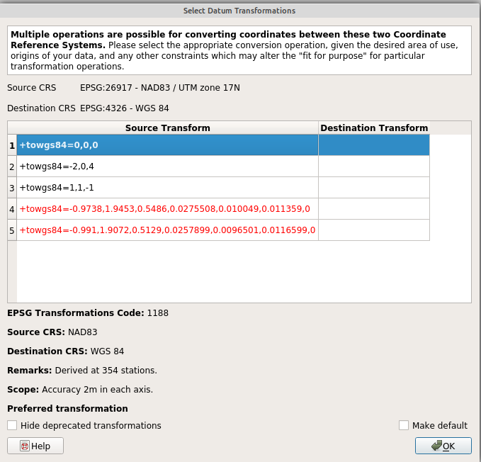
image.png

So odd behavior, but apparently not the same one.

Cheers
Andrea

···

Regards, Andrea Aime

== GeoServer Professional Services from the experts! Visit http://goo.gl/it488V for more information. == Ing. Andrea Aime @geowolf Technical Lead GeoSolutions S.A.S. Via di Montramito 3/A 55054 Massarosa (LU) phone: +39 0584 962313 fax: +39 0584 1660272 mob: +39 339 8844549 http://www.geo-solutions.it http://twitter.com/geosolutions_it ------------------------------------------------------- Con riferimento alla normativa sul trattamento dei dati personali (Reg. UE 2016/679 - Regolamento generale sulla protezione dei dati “GDPR”), si precisa che ogni circostanza inerente alla presente email (il suo contenuto, gli eventuali allegati, etc.) è un dato la cui conoscenza è riservata al/i solo/i destinatario/i indicati dallo scrivente. Se il messaggio Le è giunto per errore, è tenuta/o a cancellarlo, ogni altra operazione è illecita. Le sarei comunque grato se potesse darmene notizia. This email is intended only for the person or entity to which it is addressed and may contain information that is privileged, confidential or otherwise protected from disclosure. We remind that - as provided by European Regulation 2016/679 “GDPR” - copying, dissemination or use of this e-mail or the information herein by anyone other than the intended recipient is prohibited. If you have received this email by mistake, please notify us immediately by telephone or e-mail.

Ignore all of what I said as it applies to GML not shapefiles.

Ian

···

Ian Turton

Andrea,

When I load your layer in QGIS, it also loads with “Unknown CRS” but is assumed to be EPSG:26917. I am using QGIS 3.10.4. So there is something wrong with the way Geoserver exports the proj file for shapefiles.

Cliff

image.png

···

Cliff Patterson Ph.D.

PSD | Senior GIS Consultant
P: 519-690-2565 ext. 2616
www.psdrcs.com
London | 148 Fullarton St. 9th Floor

The WKT seems valid. What about asking QGIS devs why it’s not recognized? :smiley:
Could it be related to the proj upgrade?

Cheers
Andrea

···

== GeoServer Professional Services from the experts! Visit http://goo.gl/it488V for more information. == Ing. Andrea Aime @geowolf Technical Lead GeoSolutions S.A.S. Via di Montramito 3/A 55054 Massarosa (LU) phone: +39 0584 962313 fax: +39 0584 1660272 mob: +39 339 8844549 http://www.geo-solutions.it http://twitter.com/geosolutions_it ------------------------------------------------------- Con riferimento alla normativa sul trattamento dei dati personali (Reg. UE 2016/679 - Regolamento generale sulla protezione dei dati “GDPR”), si precisa che ogni circostanza inerente alla presente email (il suo contenuto, gli eventuali allegati, etc.) è un dato la cui conoscenza è riservata al/i solo/i destinatario/i indicati dallo scrivente. Se il messaggio Le è giunto per errore, è tenuta/o a cancellarlo, ogni altra operazione è illecita. Le sarei comunque grato se potesse darmene notizia. This email is intended only for the person or entity to which it is addressed and may contain information that is privileged, confidential or otherwise protected from disclosure. We remind that - as provided by European Regulation 2016/679 “GDPR” - copying, dissemination or use of this e-mail or the information herein by anyone other than the intended recipient is prohibited. If you have received this email by mistake, please notify us immediately by telephone or e-mail.

Hi Andrea,

I could try, but I also tried loading the same layer (the NY one you added) and it also does not load in SAGA with the correct CRS. It’s giving an EPSG number of -1.

Followup question: does something need to be enabled Geoserver avoid this problem?

Cheers,
Cliff

···

Cliff Patterson Ph.D.

PSD | Senior GIS Consultant
P: 519-690-2565 ext. 2616
www.psdrcs.com
London | 148 Fullarton St. 9th Floor

Hi Cliff,
no, there is nothing to be enabled AFAIK… I have no idea why the other software cannot read a seemingly correct WKT definition

Cheers
Andrea

···

Regards, Andrea Aime

== GeoServer Professional Services from the experts! Visit http://goo.gl/it488V for more information. == Ing. Andrea Aime @geowolf Technical Lead GeoSolutions S.A.S. Via di Montramito 3/A 55054 Massarosa (LU) phone: +39 0584 962313 fax: +39 0584 1660272 mob: +39 339 8844549 http://www.geo-solutions.it http://twitter.com/geosolutions_it ------------------------------------------------------- Con riferimento alla normativa sul trattamento dei dati personali (Reg. UE 2016/679 - Regolamento generale sulla protezione dei dati “GDPR”), si precisa che ogni circostanza inerente alla presente email (il suo contenuto, gli eventuali allegati, etc.) è un dato la cui conoscenza è riservata al/i solo/i destinatario/i indicati dallo scrivente. Se il messaggio Le è giunto per errore, è tenuta/o a cancellarlo, ogni altra operazione è illecita. Le sarei comunque grato se potesse darmene notizia. This email is intended only for the person or entity to which it is addressed and may contain information that is privileged, confidential or otherwise protected from disclosure. We remind that - as provided by European Regulation 2016/679 “GDPR” - copying, dissemination or use of this e-mail or the information herein by anyone other than the intended recipient is prohibited. If you have received this email by mistake, please notify us immediately by telephone or e-mail.