[GRASS-dev] Making start of GRASS GIS easier for newcomers

On Fri, Jan 23, 2015 at 11:07 AM, Markus Neteler <neteler@osgeo.org> wrote:

On Jan 23, 2015 9:26 AM, "Paulo van Breugel" <p.vanbreugel@gmail.com> wrote:

On Fri, Jan 23, 2015 at 9:20 AM, Markus Neteler <neteler@osgeo.org> wrote:

Hi,

my motivation to discuss the current welcome screen is that too many
potential new users try to launch GRASS, do not get past that screen and
walk away ("too difficult"). Yes, and they will likely not read the manual
but just take another GIS.
This is a multiple times reported fact.

Let's solve this. Otherwise it is too sad.

I agree, but I think we should be careful to weight in the reasons why
users stay with GRASS GIS as well.

If you reread my comment, it was about people new to GRASS. My personal
objective with the new release us to get the user community enlarged.

But that is perhaps not as much about creating a better/alternative
welcome screen

Indeed it is. Believe me, I am following the community for 15+ years now.

That is why I suggested a minimal (minimal information content)
welcome screen with one OK button and one change button. The OK button
should be prominently placed, the user must immediately see that all
is needed to get started is to press OK. This welcome screen could be
written such that practically nothing but wx needs to be imported,
which means that the splash screen can go away. Because of the little
amount of content (text + buttons), there would be enough space for
graphics even on small screens.

You could have drop-down boxes for location and mapset to offer a
choice instead of fixed text.

I agree that the current welcome screen is a big barrier. Most of the
time you select location and mapset and start, leaving everything else
as it is. That means everything else can be removed.

Markus M

and more about some of the more radical changes proposed.

This is not related to this thread but something for GRASS 8.

Markus

PS: the current screen may optionally remain.

_______________________________________________
grass-dev mailing list
grass-dev@lists.osgeo.org
http://lists.osgeo.org/mailman/listinfo/grass-dev
_______________________________________________
grass-dev mailing list
grass-dev@lists.osgeo.org
http://lists.osgeo.org/mailman/listinfo/grass-dev

On Fri, Jan 23, 2015 at 1:14 PM, Yann Chemin <ychemin@gmail.com> wrote:

On 23 January 2015 at 16:49, Rainer M Krug <Rainer@krugs.de> wrote:

Yann Chemin <ychemin@gmail.com> writes:

> On 23 January 2015 at 15:46, Martin Landa <landa.martin@gmail.com>
> wrote:
>
>> Hi,
>>
>> 2015-01-23 9:20 GMT+01:00 Markus Neteler <neteler@osgeo.org>:
>> > my motivation to discuss the current welcome screen is that too many
>> > potential new users try to launch GRASS, do not get past that screen
>> > and
>> > walk away ("too difficult"). Yes, and they will likely not read the
>> manual
>> > but just take another GIS.
>> > This is a multiple times reported fact.
>>
>> I have met a lot of GIS specialists who told me: I tried several times
>> to use GRASS in different decades and I end up with the same result, I
>> didn't managed to get my data in, so I gave up.
>>
>> Yes, I also had those experiences told to me.
> Is it possible to open GRASS GIS wxGUI without setting the
> GISDB/Location/mapset yet?
> Then from "inside the opened software" you will need to go through those
> steps anyway before doing anything...
> Would that make any psychological difference?

I think this would make a huge difference - especially if the creation
could be done by triggerd upon import and

hmm that would be cool !
running r(v).in.* without GISDBASE or Location or mapset could trigger a
wizard to set them up...

This is the current location wizard.

The original topic was import and on-the-fly reprojection without the
need to create a new location. This can be easily done by either a new
script that calls r.in.gdal/v.in.ogr + r.proj/v.proj which creates the
new location internally and deletes it when done, or a wizard doing
the same thing. The user does not even notice that a temporary
location was created. Sextante for example works this way.

Markus M

- asking for a directory (for the db),
- name of the location,
- name of the mapset, and
- taking the other parameter (projection, extend) from the data to be
  imported.

Until a mapset is opened, the non-usable menu items could be greyed
out.

Sounds like a nice option, as it will direct newbies to modules that import
data (then trigger the creation wizard)

Rainer

>
>
>> It' a sign in my eyes that we should think how to simplify this step
>> :wink:
>>
>> Martin
>>
>> --
>> Martin Landa
>> http://geo.fsv.cvut.cz/gwiki/Landa
>> http://gismentors.eu/mentors/landa
>> _______________________________________________
>> grass-dev mailing list
>> grass-dev@lists.osgeo.org
>> http://lists.osgeo.org/mailman/listinfo/grass-dev
>>

--
Rainer M. Krug
email: Rainer<at>krugs<dot>de
PGP: 0x0F52F982

--
----

_______________________________________________
grass-dev mailing list
grass-dev@lists.osgeo.org
http://lists.osgeo.org/mailman/listinfo/grass-dev

Hi,

···

On Fri, Jan 23, 2015 at 2:10 PM, Markus Metz <markus.metz.giswork@gmail.com> wrote:

That is why I suggested a minimal (minimal information content)
welcome screen with one OK button and one change button. The OK button
should be prominently placed, the user must immediately see that all
is needed to get started is to press OK. This welcome screen could be
written such that practically nothing but wx needs to be imported,
which means that the splash screen can go away. Because of the little
amount of content (text + buttons), there would be enough space for
graphics even on small screens.

You could have drop-down boxes for location and mapset to offer a
choice instead of fixed text.

Do I understand correctly that such drop-down boxes to change current location and mapset are to be found at the stage when GRASS is already started? Meaning that you are in a XY empty location and you can choose to go directly to a different one without restarting GRASS? If this is your proposal, I think that this would indeed do a huge difference to anyone working in grass, not only newcomers, in terms of practicality

Best regards,

Dr. Margherita DI LEO
Scientific / technical project officer

European Commission - DG JRC
Institute for Environment and Sustainability (IES)
Via Fermi, 2749
I-21027 Ispra (VA) - Italy - TP 261

Tel. +39 0332 78 3600
margherita.di-leo@jrc.ec.europa.eu

Disclaimer: The views expressed are purely those of the writer and may not in any circumstance be regarded as stating an official position of the European Commission.

On Fri, Jan 23, 2015 at 2:30 PM, Markus Metz <markus.metz.giswork@gmail.com>
wrote:

On Fri, Jan 23, 2015 at 1:14 PM, Yann Chemin <ychemin@gmail.com> wrote:
>
>
>>
> hmm that would be cool !
> running r(v).in.* without GISDBASE or Location or mapset could trigger a
> wizard to set them up...

This is the current location wizard.

The original topic was import and on-the-fly reprojection without the
need to create a new location. This can be easily done by either a new
script that calls r.in.gdal/v.in.ogr + r.proj/v.proj which creates the
new location internally and deletes it when done, or a wizard doing
the same thing. The user does not even notice that a temporary
location was created. Sextante for example works this way.

This would be lovely to have! Perhaps using ogr2ogr / gdalwarp before
importing would be even faster.

--
Best regards,

Dr. Margherita DI LEO
Scientific / technical project officer

European Commission - DG JRC
Institute for Environment and Sustainability (IES)
Via Fermi, 2749
I-21027 Ispra (VA) - Italy - TP 261

Tel. +39 0332 78 3600
margherita.di-leo@jrc.ec.europa.eu

Disclaimer: The views expressed are purely those of the writer and may not
in any circumstance be regarded as stating an official position of the
European Commission.

On Fri, Jan 23, 2015 at 10:34 AM, Margherita Di Leo <diregola@gmail.com>
wrote:

Hi,

On Fri, Jan 23, 2015 at 2:10 PM, Markus Metz <
markus.metz.giswork@gmail.com> wrote:

That is why I suggested a minimal (minimal information content)
welcome screen with one OK button and one change button. The OK button
should be prominently placed, the user must immediately see that all
is needed to get started is to press OK. This welcome screen could be
written such that practically nothing but wx needs to be imported,
which means that the splash screen can go away. Because of the little
amount of content (text + buttons), there would be enough space for
graphics even on small screens.

You could have drop-down boxes for location and mapset to offer a
choice instead of fixed text.

Do I understand correctly that such drop-down boxes to change current
location and mapset are to be found at the stage when GRASS is already
started? Meaning that you are in a XY empty location and you can choose to
go directly to a different one without restarting GRASS? If this is your
proposal, I think that this would indeed do a huge difference to anyone
working in grass, not only newcomers, in terms of practicality

That's already there. I am not sure if it makes such a huge difference.

Anna

--
Best regards,

Dr. Margherita DI LEO
Scientific / technical project officer

European Commission - DG JRC
Institute for Environment and Sustainability (IES)
Via Fermi, 2749
I-21027 Ispra (VA) - Italy - TP 261

Tel. +39 0332 78 3600
margherita.di-leo@jrc.ec.europa.eu

Disclaimer: The views expressed are purely those of the writer and may not
in any circumstance be regarded as stating an official position of the
European Commission.

_______________________________________________
grass-dev mailing list
grass-dev@lists.osgeo.org
http://lists.osgeo.org/mailman/listinfo/grass-dev

On 23 January 2015 at 22:18, Anna Petrášová <kratochanna@gmail.com> wrote:

On Fri, Jan 23, 2015 at 10:34 AM, Margherita Di Leo <diregola@gmail.com>
wrote:

Hi,

On Fri, Jan 23, 2015 at 2:10 PM, Markus Metz <
markus.metz.giswork@gmail.com> wrote:

That is why I suggested a minimal (minimal information content)
welcome screen with one OK button and one change button. The OK button
should be prominently placed, the user must immediately see that all
is needed to get started is to press OK. This welcome screen could be
written such that practically nothing but wx needs to be imported,
which means that the splash screen can go away. Because of the little
amount of content (text + buttons), there would be enough space for
graphics even on small screens.

You could have drop-down boxes for location and mapset to offer a
choice instead of fixed text.

Do I understand correctly that such drop-down boxes to change current
location and mapset are to be found at the stage when GRASS is already
started? Meaning that you are in a XY empty location and you can choose to
go directly to a different one without restarting GRASS? If this is your
proposal, I think that this would indeed do a huge difference to anyone
working in grass, not only newcomers, in terms of practicality

That's already there. I am not sure if it makes such a huge difference.

It is there indeed, but there is here an element of perceived availability
that maybe needed, or maybe perceived focus in the work flow...

Anna

--
Best regards,

Dr. Margherita DI LEO
Scientific / technical project officer

European Commission - DG JRC
Institute for Environment and Sustainability (IES)
Via Fermi, 2749
I-21027 Ispra (VA) - Italy - TP 261

Tel. +39 0332 78 3600
margherita.di-leo@jrc.ec.europa.eu

Disclaimer: The views expressed are purely those of the writer and may
not in any circumstance be regarded as stating an official position of the
European Commission.

_______________________________________________
grass-dev mailing list
grass-dev@lists.osgeo.org
http://lists.osgeo.org/mailman/listinfo/grass-dev

_______________________________________________
grass-dev mailing list
grass-dev@lists.osgeo.org
http://lists.osgeo.org/mailman/listinfo/grass-dev

--
----

Yann Chemin wrote:

> hmm that would be cool !
> running r(v).in.* without GISDBASE or Location or mapset could trigger a
> wizard to set them up...

Markus Metz:

This is the current location wizard.

The original topic was import and on-the-fly reprojection without the
need to create a new location. This can be easily done by either a new
script that calls r.in.gdal/v.in.ogr + r.proj/v.proj which creates the
new location internally and deletes it when done, or a wizard doing
the same thing. The user does not even notice that a temporary
location was created. Sextante for example works this way.

Margherita Di Leo wrote:

This would be lovely to have! Perhaps using ogr2ogr / gdalwarp before
importing would be even faster.

That would be a Huge time-saver. Thanks, Nikos

On Fri, Jan 23, 2015 at 4:34 PM, Margherita Di Leo <diregola@gmail.com> wrote:

Hi,

On Fri, Jan 23, 2015 at 2:10 PM, Markus Metz <markus.metz.giswork@gmail.com>
wrote:

That is why I suggested a minimal (minimal information content)
welcome screen with one OK button and one change button. The OK button
should be prominently placed, the user must immediately see that all
is needed to get started is to press OK. This welcome screen could be
written such that practically nothing but wx needs to be imported,
which means that the splash screen can go away. Because of the little
amount of content (text + buttons), there would be enough space for
graphics even on small screens.

You could have drop-down boxes for location and mapset to offer a
choice instead of fixed text.

Do I understand correctly that such drop-down boxes to change current
location and mapset are to be found at the stage when GRASS is already
started?

No, I am talking about a minimal welcome screen to replace the current
welcome screen. This screen appears (current behaviour) before GRASS
GIS is started.

Markus M

Meaning that you are in a XY empty location and you can choose to
go directly to a different one without restarting GRASS? If this is your
proposal, I think that this would indeed do a huge difference to anyone
working in grass, not only newcomers, in terms of practicality

--
Best regards,

Dr. Margherita DI LEO
Scientific / technical project officer

European Commission - DG JRC
Institute for Environment and Sustainability (IES)
Via Fermi, 2749
I-21027 Ispra (VA) - Italy - TP 261

Tel. +39 0332 78 3600
margherita.di-leo@jrc.ec.europa.eu

Disclaimer: The views expressed are purely those of the writer and may not
in any circumstance be regarded as stating an official position of the
European Commission.

2015-01-23 21:54 GMT+02:00 Markus Metz <markus.metz.giswork@gmail.com>:

On Fri, Jan 23, 2015 at 4:34 PM, Margherita Di Leo <diregola@gmail.com> wrote:

No, I am talking about a minimal welcome screen to replace the current
welcome screen. This screen appears (current behaviour) before GRASS
GIS is started.

Markus M

If I got you right, your proposal is to replace:
Launch GRASS -> click on location -> click on mapset -> click on Start
with:
Launch GRASS -> click on "change location" -> click on location ->
click on "change mapset" -> click on mapset -> click on Start

If it is so, I vote with all of my four against.

If you wan to make startup screen more easy, just 1) hide GISDBASE a
bit (instead of showing it as a input field, display as a text with
"change" button); 2) add "Import data" button that starts Location
wizard but by "guessing" parameters based on selected file (with an
option to change, of course).
Having a "project set up" screen as a first screen while launching
some program is not so uncommon in area of pro software. I don't see
how users would benefit if they would be dropped in a some random
location with most of menu items being not completely functional, "add
raster/vector" showing empty lists etc. Even worse - there are plenty
of ESRI Shapefiles without .prj and other datasets without SRS
definitions - users would just start to do their work in XY locations
till it will lead to furtherer problems (Why in ArcGIS is see those
data together, but in GRASS I don't? - one of most common complaints
of my students. Hint - messed up SRS definitions masked by "easy to
use" functionality. How should area / distance be calculated in XY
location for LL data?!?)

Everything should be made as simple as possible, but not simpler.

Maris.

On Wed, Jan 21, 2015 at 11:29 PM, Vaclav Petras <wenzeslaus@gmail.com>
wrote:

On Wed, Jan 21, 2015 at 5:15 PM, Vaclav Petras <wenzeslaus@gmail.com>
wrote:

To satisfy everybody, I suggest to provide a buttons with something like
"Take me to LL", "Take me to default location" and "Take me to XY". What do
you think about that?

But the real improvement should be the messages which would guide you
through the process.

So, here is screenshot and diff for new layout of the window together the
description what the things are useful for. The descriptions can be easily
changed, they are wrapped texts, so they will work well with translations.
So, feel free to suggest different ones. We can also make them "gray" as
suggested earlier.

I used GRASS Location and Location. I though that GRASS could help to
emphasize that it is something GRASS-related and few people were using
Location and Mapset with capital letter which could say that it is a
something like files format or spatial database name. I aimed to address
the things I considered confusing. I'm not sure about the GRASS GIS data
directory as I mentioned earlier.

Now it is higher then the old one but with removal of the image it will be
smaller. If a small-enough image is used, it could be the same. I would
like to not include the image to have more space for the error messages
(currently one line between GISDBASE and Location boxes), so messages can
be longer and perhaps some what to do next tips can be shown as well. The
position of this text can/should be changed, now middle of the window
(usually these are at the bottom or at the top). However, without image it
might be actually a little boring.

I reorganized the buttons to manage the (list of) Locations and (list of)
Mapsets, so now it looks like any other lists, e.g. in Simple Layer Manager
or in Cartographic Composer. In future we can add buttons, for example
unpack a zipped location or download sample datasets in case of Locations
and show existing maps button in case of Mapsets.

Done in r64345.

Now the change of minimal height is needed to actually make it work on
small screens.

Please, read the previous message and commit message for a discussion and
description.

http://trac.osgeo.org/grass/changeset/64345

Hi,

2015-01-28 19:59 GMT+01:00 Vaclav Petras <wenzeslaus@gmail.com>:

Done in r64345.

Now the change of minimal height is needed to actually make it work on small
screens.

thanks. I would vote to make description text gray. Martin

--
Martin Landa
http://geo.fsv.cvut.cz/gwiki/Landa
http://gismentors.eu/mentors/landa

On Wed, Jan 28, 2015 at 9:29 PM, Martin Landa <landa.martin@gmail.com> wrote:

Hi,

2015-01-28 19:59 GMT+01:00 Vaclav Petras <wenzeslaus@gmail.com>:

Done in r64345.

Good, now we have a better discussion base.

Now the change of minimal height is needed to actually make it work on small
screens.

thanks. I would vote to make description text gray. Martin

Yes, I thought the same: the explanations in a grey-ish color.

thanks
Markus

On 28/01/15 19:59, Vaclav Petras wrote:

On Wed, Jan 21, 2015 at 11:29 PM, Vaclav Petras <wenzeslaus@gmail.com
<mailto:wenzeslaus@gmail.com>> wrote:

    On Wed, Jan 21, 2015 at 5:15 PM, Vaclav Petras <wenzeslaus@gmail.com
    <mailto:wenzeslaus@gmail.com>> wrote:

        To satisfy everybody, I suggest to provide a buttons with
        something like "Take me to LL", "Take me to default location"
        and "Take me to XY". What do you think about that?

        But the real improvement should be the messages which would
        guide you through the process.

    So, here is screenshot and diff for new layout of the window
    together the description what the things are useful for. The
    descriptions can be easily changed, they are wrapped texts, so they
    will work well with translations. So, feel free to suggest different
    ones. We can also make them "gray" as suggested earlier.

    I used GRASS Location and Location. I though that GRASS could help
    to emphasize that it is something GRASS-related and few people were
    using Location and Mapset with capital letter which could say that
    it is a something like files format or spatial database name. I
    aimed to address the things I considered confusing. I'm not sure
    about the GRASS GIS data directory as I mentioned earlier.

    Now it is higher then the old one but with removal of the image it
    will be smaller. If a small-enough image is used, it could be the
    same. I would like to not include the image to have more space for
    the error messages (currently one line between GISDBASE and Location
    boxes), so messages can be longer and perhaps some what to do next
    tips can be shown as well. The position of this text can/should be
    changed, now middle of the window (usually these are at the bottom
    or at the top). However, without image it might be actually a little
    boring.

    I reorganized the buttons to manage the (list of) Locations and
    (list of) Mapsets, so now it looks like any other lists, e.g. in
    Simple Layer Manager or in Cartographic Composer. In future we can
    add buttons, for example unpack a zipped location or download sample
    datasets in case of Locations and show existing maps button in case
    of Mapsets.

Done in r64345.

Now the change of minimal height is needed to actually make it work on
small screens.

Please, read the previous message and commit message for a discussion
and description.

Generally, I like what I see, but I also have to admit that personally, and apparently contrary to many others, I do not really see as much need to change much in the GRASS startup.

I just have two reactions:

"Location represents a project."

I'm not sure I like this restriction to location=project. For my part I often use location=projection and mapset=project, but this depends. I'm afraid that such a semantic limitation in the startup screen will strongly influence users to go into just one direction...

On 22/01/15 05:29, Vaclav Petras wrote:> A "Skip" button can be added next to Start button, once implemented. I
> think that XY location in /tmp/grassdata would be appropriate.

I'm very strongly opposed to this idea. You can be sure that many people will abuse this horribly without knowing what they are doing. In my eyes, GRASS should continue to impose a choice of projection system before working with data.

If we want to give people the opportunity to test GRASS, I prefer the option of a button that downloads and unpacks a very light demo location.

Moritz

On Jan 29, 2015 9:47 AM, “Moritz Lennert” <mlennert@club.worldonline.be> wrote:

On 28/01/15 19:59, Vaclav Petras wrote:

On 22/01/15 05:29, Vaclav Petras wrote:> A “Skip” button can be added next to Start button, once implemented. I

think that XY location in /tmp/grassdata would be appropriate.

I’m very strongly opposed to this idea.

I fully agree: xy is a very bad idea.
Also, let’s use the home and not /tmp which is on modern systems a tmpfs directory which is in RAM only and not reboot safe.

You can be sure that many people will abuse this horribly without knowing what they are doing.

Exactly.

In my eyes, GRASS should continue to impose a choice of projection system before working with data.

If we want to give people the opportunity to test GRASS, I prefer the option of a button that downloads and unpacks a very light demo location.

Yes. The winGRASS installer does that already reasonably. Or, as suggested, launch latlong rather than xy etc.

Markus

Moritz

Vaclav Petras wrote:

        To satisfy everybody, I suggest to provide a buttons with
        something like "Take me to LL", "Take me to default location"
        and "Take me to XY". What do you think about that?

        But the real improvement should be the messages which would
        guide you through the process.

Hi Vaclav, and all. Thanks for the continuous hard working.

    So, here is screenshot and diff for new layout of the window
    together the description what the things are useful for. The
    descriptions can be easily changed, they are wrapped texts, so they
    will work well with translations. So, feel free to suggest different
    ones. We can also make them "gray" as suggested earlier.

    I used GRASS Location and Location. I though that GRASS could help
    to emphasize that it is something GRASS-related and few people were
    using Location and Mapset with capital letter which could say that
    it is a something like files format or spatial database name. I
    aimed to address the things I considered confusing. I'm not sure
    about the GRASS GIS data directory as I mentioned earlier.

    Now it is higher then the old one but with removal of the image it
    will be smaller. If a small-enough image is used, it could be the
    same. I would like to not include the image to have more space for
    the error messages (currently one line between GISDBASE and Location
    boxes), so messages can be longer and perhaps some what to do next
    tips can be shown as well. The position of this text can/should be
    changed, now middle of the window (usually these are at the bottom
    or at the top). However, without image it might be actually a little
    boring.

    I reorganized the buttons to manage the (list of) Locations and
    (list of) Mapsets, so now it looks like any other lists, e.g. in
    Simple Layer Manager or in Cartographic Composer. In future we can
    add buttons, for example unpack a zipped location or download sample
    datasets in case of Locations and show existing maps button in case
    of Mapsets.

Done in r64345.
Now the change of minimal height is needed to actually make it work on
small screens.
Please, read the previous message and commit message for a discussion
and description.

Moritz Lennert wrote:

Generally, I like what I see, but I also have to admit that
personally, and apparently contrary to many others, I do not really
see as much need to change much in the GRASS startup.

I just have two reactions:

"Location represents a project."

I'm not sure I like this restriction to location=project.

Me too.

For my part
I often use location=projection and mapset=project, but this depends.

If it is any worth, I use single directories for projects.- Then Locations for projections and Mapsets to organise everything as I think is necessary underneath/inside.

I'm afraid that such a semantic limitation in the startup screen will
strongly influence users to go into just one direction...

Yes, please be more cautious here.

Vaclav Petras wrote:

A "Skip" button can be added next to Start button, once implemented.
I think that XY location in /tmp/grassdata would be appropriate.

I'm very strongly opposed to this idea. You can be sure that many
people will abuse this horribly without knowing what they are doing.
In my eyes, GRASS should continue to impose a choice of projection
system before working with data.

I use an XY location for various quick-tests. It's in my generic "grassdb" directory, along with the other "projects".

If we want to give people the opportunity to test GRASS, I prefer the
option of a button that downloads and unpacks a very light demo
location.

Nikos

Is there a place to see a screen shot of what is proposed? I suggested some wording changes awhile back but I don't know if they are incorporated or not.

Michael
____________________
C. Michael Barton
Director, Center for Social Dynamics & Complexity
Professor of Anthropology, School of Human Evolution & Social Change
Head, Graduate Faculty in Complex Adaptive Systems Science
Arizona State University

voice: 480-965-6262 (SHESC), 480-965-8130/727-9746 (CSDC)
fax: 480-965-7671 (SHESC), 480-727-0709 (CSDC)
www: http://www.public.asu.edu/~cmbarton, http://csdc.asu.edu

On Jan 29, 2015, at 1:46 AM, Moritz Lennert <mlennert@club.worldonline.be> wrote:

On 28/01/15 19:59, Vaclav Petras wrote:

On Wed, Jan 21, 2015 at 11:29 PM, Vaclav Petras <wenzeslaus@gmail.com
<mailto:wenzeslaus@gmail.com>> wrote:

   On Wed, Jan 21, 2015 at 5:15 PM, Vaclav Petras <wenzeslaus@gmail.com
   <mailto:wenzeslaus@gmail.com>> wrote:

       To satisfy everybody, I suggest to provide a buttons with
       something like "Take me to LL", "Take me to default location"
       and "Take me to XY". What do you think about that?

       But the real improvement should be the messages which would
       guide you through the process.

   So, here is screenshot and diff for new layout of the window
   together the description what the things are useful for. The
   descriptions can be easily changed, they are wrapped texts, so they
   will work well with translations. So, feel free to suggest different
   ones. We can also make them "gray" as suggested earlier.

   I used GRASS Location and Location. I though that GRASS could help
   to emphasize that it is something GRASS-related and few people were
   using Location and Mapset with capital letter which could say that
   it is a something like files format or spatial database name. I
   aimed to address the things I considered confusing. I'm not sure
   about the GRASS GIS data directory as I mentioned earlier.

   Now it is higher then the old one but with removal of the image it
   will be smaller. If a small-enough image is used, it could be the
   same. I would like to not include the image to have more space for
   the error messages (currently one line between GISDBASE and Location
   boxes), so messages can be longer and perhaps some what to do next
   tips can be shown as well. The position of this text can/should be
   changed, now middle of the window (usually these are at the bottom
   or at the top). However, without image it might be actually a little
   boring.

   I reorganized the buttons to manage the (list of) Locations and
   (list of) Mapsets, so now it looks like any other lists, e.g. in
   Simple Layer Manager or in Cartographic Composer. In future we can
   add buttons, for example unpack a zipped location or download sample
   datasets in case of Locations and show existing maps button in case
   of Mapsets.

Done in r64345.

Now the change of minimal height is needed to actually make it work on
small screens.

Please, read the previous message and commit message for a discussion
and description.

Generally, I like what I see, but I also have to admit that personally, and apparently contrary to many others, I do not really see as much need to change much in the GRASS startup.

I just have two reactions:

"Location represents a project."

I'm not sure I like this restriction to location=project. For my part I often use location=projection and mapset=project, but this depends. I'm afraid that such a semantic limitation in the startup screen will strongly influence users to go into just one direction...

On 22/01/15 05:29, Vaclav Petras wrote:> A "Skip" button can be added next to Start button, once implemented. I
> think that XY location in /tmp/grassdata would be appropriate.

I'm very strongly opposed to this idea. You can be sure that many people will abuse this horribly without knowing what they are doing. In my eyes, GRASS should continue to impose a choice of projection system before working with data.

If we want to give people the opportunity to test GRASS, I prefer the option of a button that downloads and unpacks a very light demo location.

Moritz

On Thu, Jan 29, 2015 at 1:20 PM, Michael Barton <Michael.Barton@asu.edu> wrote:

Is there a place to see a screen shot of what is proposed? I suggested some wording changes awhile back but I don't know if they are incorporated or not.

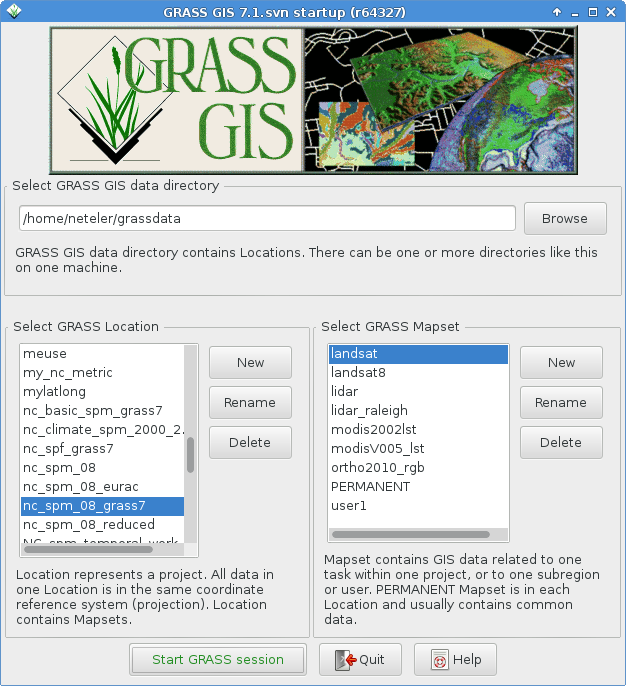
Attached the draft version from trunk (updated 2hs ago). Obviously yet
with the old logo etc.

Markus

(attachments)

draft_g7_welcome_screen.png

Could we have a proposed new banner in trunk too.
It really helps having it on your computer…

Maybe the smallest one makes sense for all screen sizes
http://grasswiki.osgeo.org/wiki/File:GRASSGIS_welcome_banner3.jpg

I wonder if Vincent could make it with “GRASS GIS” in Fira Sans as in the splash screen?

Cheers,
Yann

···

On 29 January 2015 at 18:03, Markus Neteler <neteler@osgeo.org> wrote:

On Thu, Jan 29, 2015 at 1:20 PM, Michael Barton <Michael.Barton@asu.edu> wrote:

Is there a place to see a screen shot of what is proposed? I suggested some wording changes awhile back but I don’t know if they are incorporated or not.

Attached the draft version from trunk (updated 2hs ago). Obviously yet
with the old logo etc.

Markus


grass-dev mailing list
grass-dev@lists.osgeo.org
http://lists.osgeo.org/mailman/listinfo/grass-dev


Le jeudi 29 janvier 2015 à 18:19 +0530, Yann Chemin a écrit :

I wonder if Vincent could make it with "GRASS GIS" in Fira Sans as in
the splash screen?

Yes, in a while.

Here I put the updated banner:
http://grasswiki.osgeo.org/wiki/Identity#Proposals_2

attached is the jpg label.

Le jeudi 29 janvier 2015 à 14:12 +0100, Vincent Bain a écrit :

Le jeudi 29 janvier 2015 à 18:19 +0530, Yann Chemin a écrit :
> I wonder if Vincent could make it with "GRASS GIS" in Fira Sans as in
> the splash screen?

Yes, in a while.

_______________________________________________
grass-dev mailing list
grass-dev@lists.osgeo.org
http://lists.osgeo.org/mailman/listinfo/grass-dev

(attachments)

GRASSGIS_welcome_banner4.jpg