[GRASS-dev] Making start of GRASS GIS easier for newcomers

On Wed, Jan 21, 2015 at 4:55 PM, Markus Neteler <neteler@osgeo.org> wrote:

On Wed, Jan 21, 2015 at 8:16 PM, Moritz Lennert
<mlennert@club.worldonline.be> wrote:
> On 21/01/15 19:35, Markus Neteler wrote:
>> In my opinion we should not have the location selection dialog at all.
>> Revolution!
>>
>> We should start GRASS right away in latlong like most GIS in the world.
>>
>> Then let the user open the dialog to change projection if desired from
>> inside.
>>
>> This would avoid a lot of questions right away.
>
> Please don't do this !

OK, now being back from phone to a real keyboard, I can write a few more
lines.

I am thinking about this issue for seeral years meanwhile (hint: I
started in 1993 to use the software, getting stuck at the text start
screen not having a manual :-).

So my full suggestions are
- beautify the actual screen (hence my recent suggestion which is
lively discussed here),
- optionally (!) allow to start GRASS without welcome/loc/mapset
screen but to open it in LatLong as described above. Again, as an
option. We could implement that in trunk and see how it goes. All the
tools to select locations, projections and such are there.

I think that you have to go all the work anyway and the dummy location is

there just to show that it is possible.

There are some potential problems, for example how it works now with the
.bash_history file?

I find the fact that GRASS does not provide a default
> projection system, but forces the user to think about projection from the
> start, one of its strengths, both for work and for teaching.

On of it strenghts, yes. But I have been teaching GRASS a lot to GIS
professionals who got trained on different systems. And many asked
"why this screen? why cannot you just start like the other GIS"? And I
tend to agree (again: optionally). The point is that we, on the
contrary to many other GIS, still have all the control mechanisms in
place which avoid that the user mixes projections. So that's all fine.

And what will you do after 'just starting'? Do you have your data as LL?

Or will you use -o flag to ignore the projection check?

Also in Portland at the FOSS4G conf (where I showcased GRASS GIS 7)
people suggested to let 'em get into the system right away. They
explained to me that a newcomer wants to see the menu to understand
how powerful the system is. But they would get stuck at the welcome
screen... Yes, and they don't want to think before they open the
program but "just try", out of curiosity.

This is a good point. I can see that. However, manual is also useful for
this. This is what I use. Works for command line programs too.

To satisfy everybody, I suggest to provide a buttons with something like
"Take me to LL", "Take me to default location" and "Take me to XY". What do
you think about that?

But the real improvement should be the messages which would guide you
through the process.

Vaclav

Perhaps we should move this discussion to a different thread and leave

this to the splash/welcome screen modernization.

Best
Markus
On Wed, Jan 21, 2015 at 5:15 PM, Vaclav Petras <wenzeslaus@gmail.com> wrote:

To satisfy everybody, I suggest to provide a buttons with something like
"Take me to LL", "Take me to default location" and "Take me to XY". What do
you think about that?

But the real improvement should be the messages which would guide you
through the process.

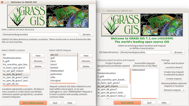
So, here is screenshot and diff for new layout of the window together the
description what the things are useful for. The descriptions can be easily
changed, they are wrapped texts, so they will work well with translations.
So, feel free to suggest different ones. We can also make them "gray" as
suggested earlier.

I used GRASS Location and Location. I though that GRASS could help to
emphasize that it is something GRASS-related and few people were using
Location and Mapset with capital letter which could say that it is a
something like files format or spatial database name. I aimed to address
the things I considered confusing. I'm not sure about the GRASS GIS data
directory as I mentioned earlier.

Now it is higher then the old one but with removal of the image it will be
smaller. If a small-enough image is used, it could be the same. I would
like to not include the image to have more space for the error messages
(currently one line between GISDBASE and Location boxes), so messages can
be longer and perhaps some what to do next tips can be shown as well. The
position of this text can/should be changed, now middle of the window
(usually these are at the bottom or at the top). However, without image it
might be actually a little boring.

I reorganized the buttons to manage the (list of) Locations and (list of)
Mapsets, so now it looks like any other lists, e.g. in Simple Layer Manager
or in Cartographic Composer. In future we can add buttons, for example
unpack a zipped location or download sample datasets in case of Locations
and show existing maps button in case of Mapsets.

A "Skip" button can be added next to Start button, once implemented. I
think that XY location in /tmp/grassdata would be appropriate.

http://lists.osgeo.org/pipermail/grass-dev/2015-January/073268.html
http://lists.osgeo.org/pipermail/grass-dev/2015-January/073266.html

(attachments)

startup_with_explanations.diff (23.9 KB)
startup_with_explanations.png

Looks good Vaclav,

it makes sense on the flow, more intuitive.

···

On 22 January 2015 at 10:05, Vaclav Petras <wenzeslaus@gmail.com> wrote:


grass-dev mailing list
grass-dev@lists.osgeo.org
http://lists.osgeo.org/mailman/listinfo/grass-dev

On Wed, Jan 21, 2015 at 5:15 PM, Vaclav Petras <wenzeslaus@gmail.com> wrote:

http://lists.osgeo.org/pipermail/grass-dev/2015-January/073268.html
http://lists.osgeo.org/pipermail/grass-dev/2015-January/073266.html

To satisfy everybody, I suggest to provide a buttons with something like “Take me to LL”, “Take me to default location” and “Take me to XY”. What do you think about that?

But the real improvement should be the messages which would guide you through the process.

So, here is screenshot and diff for new layout of the window together the description what the things are useful for. The descriptions can be easily changed, they are wrapped texts, so they will work well with translations. So, feel free to suggest different ones. We can also make them “gray” as suggested earlier.

I used GRASS Location and Location. I though that GRASS could help to emphasize that it is something GRASS-related and few people were using Location and Mapset with capital letter which could say that it is a something like files format or spatial database name. I aimed to address the things I considered confusing. I’m not sure about the GRASS GIS data directory as I mentioned earlier.

Now it is higher then the old one but with removal of the image it will be smaller. If a small-enough image is used, it could be the same. I would like to not include the image to have more space for the error messages (currently one line between GISDBASE and Location boxes), so messages can be longer and perhaps some what to do next tips can be shown as well. The position of this text can/should be changed, now middle of the window (usually these are at the bottom or at the top). However, without image it might be actually a little boring.

I reorganized the buttons to manage the (list of) Locations and (list of) Mapsets, so now it looks like any other lists, e.g. in Simple Layer Manager or in Cartographic Composer. In future we can add buttons, for example unpack a zipped location or download sample datasets in case of Locations and show existing maps button in case of Mapsets.

A “Skip” button can be added next to Start button, once implemented. I think that XY location in /tmp/grassdata would be appropriate.


Just copying my last comment from the source thread…

···

On 22 January 2015 at 10:05, Vaclav Petras <wenzeslaus@gmail.com> wrote:


grass-dev mailing list
grass-dev@lists.osgeo.org
http://lists.osgeo.org/mailman/listinfo/grass-dev

On Wed, Jan 21, 2015 at 5:15 PM, Vaclav Petras <wenzeslaus@gmail.com> wrote:

http://lists.osgeo.org/pipermail/grass-dev/2015-January/073268.html
http://lists.osgeo.org/pipermail/grass-dev/2015-January/073266.html

To satisfy everybody, I suggest to provide a buttons with something like “Take me to LL”, “Take me to default location” and “Take me to XY”. What do you think about that?

But the real improvement should be the messages which would guide you through the process.

So, here is screenshot and diff for new layout of the window together the description what the things are useful for. The descriptions can be easily changed, they are wrapped texts, so they will work well with translations. So, feel free to suggest different ones. We can also make them “gray” as suggested earlier.

I used GRASS Location and Location. I though that GRASS could help to emphasize that it is something GRASS-related and few people were using Location and Mapset with capital letter which could say that it is a something like files format or spatial database name. I aimed to address the things I considered confusing. I’m not sure about the GRASS GIS data directory as I mentioned earlier.

Now it is higher then the old one but with removal of the image it will be smaller. If a small-enough image is used, it could be the same. I would like to not include the image to have more space for the error messages (currently one line between GISDBASE and Location boxes), so messages can be longer and perhaps some what to do next tips can be shown as well. The position of this text can/should be changed, now middle of the window (usually these are at the bottom or at the top). However, without image it might be actually a little boring.

I reorganized the buttons to manage the (list of) Locations and (list of) Mapsets, so now it looks like any other lists, e.g. in Simple Layer Manager or in Cartographic Composer. In future we can add buttons, for example unpack a zipped location or download sample datasets in case of Locations and show existing maps button in case of Mapsets.

A “Skip” button can be added next to Start button, once implemented. I think that XY location in /tmp/grassdata would be appropriate.


   > > > I find the fact that GRASS does not provide a default
   >> > projection system, but forces the user to think about projection
from the
   >> > start, one of its strengths, both for work and for teaching.

   >> On of it strenghts, yes. But I have been teaching GRASS a lot to GIS
   >> professionals who got trained on different systems. And many asked
   >> "why this screen? why cannot you just start like the other GIS"? And I
   > >tend to agree (again: optionally). The point is that we, on the
   > >contrary to many other GIS, still have all the control mechanisms in
   >> place which avoid that the user mixes projections. So that's all fine.

And what will you do after 'just starting'? Do you have your data as LL? Or

will you use -o flag to ignore

the projection check?

I agree. I can't see any benefit to be automatically in a LL location, as in
many cases your data will be in other SRSs.

what may be make sense: define your projection/srs by import your first data
and offer this option in a prominent way in the welcome screen and not
"hidden" in the location wizzard as at the moment.

and what I've learned from GRASS GIS :slight_smile: when using other GIS software:
first check SRSs of my data, open GIS software, define SRS and then load
data.

my 0.02c

-----
best regards
Helmut
--
View this message in context: http://osgeo-org.1560.x6.nabble.com/Making-start-of-GRASS-GIS-easier-for-newcomers-tp5182982p5183058.html
Sent from the Grass - Dev mailing list archive at Nabble.com.

On Wed, Jan 21, 2015 at 11:15 PM, Vaclav Petras <wenzeslaus@gmail.com> wrote:

On Wed, Jan 21, 2015 at 4:55 PM, Markus Neteler <neteler@osgeo.org> wrote:

On Wed, Jan 21, 2015 at 8:16 PM, Moritz Lennert
<mlennert@club.worldonline.be> wrote:
> On 21/01/15 19:35, Markus Neteler wrote:
>> In my opinion we should not have the location selection dialog at all.
>> Revolution!
>>
>> We should start GRASS right away in latlong like most GIS in the world.
>>
>> Then let the user open the dialog to change projection if desired from
>> inside.
>>
>> This would avoid a lot of questions right away.
>
> Please don't do this !

OK, now being back from phone to a real keyboard, I can write a few more
lines.

I am thinking about this issue for seeral years meanwhile (hint: I
started in 1993 to use the software, getting stuck at the text start
screen not having a manual :-).

So my full suggestions are
- beautify the actual screen (hence my recent suggestion which is
lively discussed here),
- optionally (!) allow to start GRASS without welcome/loc/mapset
screen but to open it in LatLong as described above. Again, as an
option. We could implement that in trunk and see how it goes. All the
tools to select locations, projections and such are there.

I think that you have to go all the work anyway and the dummy location is
there just to show that it is possible.

There are some potential problems, for example how it works now with the
.bash_history file?

> I find the fact that GRASS does not provide a default
> projection system, but forces the user to think about projection from
> the
> start, one of its strengths, both for work and for teaching.

On of it strenghts, yes. But I have been teaching GRASS a lot to GIS
professionals who got trained on different systems. And many asked
"why this screen? why cannot you just start like the other GIS"? And I
tend to agree (again: optionally). The point is that we, on the
contrary to many other GIS, still have all the control mechanisms in
place which avoid that the user mixes projections. So that's all fine.

And what will you do after 'just starting'? Do you have your data as LL? Or
will you use -o flag to ignore the projection check?

Also in Portland at the FOSS4G conf (where I showcased GRASS GIS 7)
people suggested to let 'em get into the system right away. They
explained to me that a newcomer wants to see the menu to understand
how powerful the system is. But they would get stuck at the welcome
screen... Yes, and they don't want to think before they open the
program but "just try", out of curiosity.

This is a good point. I can see that. However, manual is also useful for
this. This is what I use. Works for command line programs too.

To satisfy everybody, I suggest to provide a buttons with something like
"Take me to LL", "Take me to default location" and "Take me to XY". What do
you think about that?

But the real improvement should be the messages which would guide you
through the process.

A suggestion for a compromise:

Have a minimal welcome screen that says something like
"Starting GRASS GIS in location X, mapset Y"
nothing else, no list of all the available locations and mapsets

Only two buttons: OK, Change
Make OK the default, Change will bring up the current welcome screen.

The user has then just to hit enter and GRASS is running. This would
reduce the (confusing) amount of information on the current welcome
screen. It would also give more space for a little graphic :wink:

Location and mapset can be taken from GISRC, if that does not exist,
create a new GISDBASE in the user's home, put the demolocation in it
and use this (I think the wingrass installer is already doing that).

Markus M

On 22.01.2015 10:32, Helmut Kudrnovsky wrote:

> > I find the fact that GRASS does not provide a default
> > projection system, but forces the user to think about projection from the
> > start, one of its strengths, both for work and for teaching.

   >> On of it strenghts, yes. But I have been teaching GRASS a lot to GIS
   >> professionals who got trained on different systems. And many asked
   >> "why this screen? why cannot you just start like the other GIS"? And I
   > >tend to agree (again: optionally). The point is that we, on the
   > >contrary to many other GIS, still have all the control mechanisms in
   >> place which avoid that the user mixes projections. So that's all fine.

And what will you do after 'just starting'? Do you have your data as LL? Or

will you use -o flag to ignore

the projection check?

I agree. I can't see any benefit to be automatically in a LL location, as in
many cases your data will be in other SRSs.

what may be make sense: define your projection/srs by import your first data
and offer this option in a prominent way in the welcome screen and not
"hidden" in the location wizzard as at the moment.

+1

Nikos

and what I've learned from GRASS GIS :slight_smile: when using other GIS software:
first check SRSs of my data, open GIS software, define SRS and then load
data.

my 0.02c

Markus Metz wrote:

A suggestion for a compromise:

Have a minimal welcome screen that says something like
"Starting GRASS GIS in location X, mapset Y"
nothing else, no list of all the available locations and mapsets

Only two buttons: OK, Change
Make OK the default, Change will bring up the current welcome screen.

That sounds nice!

And let the "Change" lead to a series of simple, yet distinct, 4 steps to create:

1) Location (define the SRS, best by getting it from georeferenced data, if available)
2) Propose to import data in the PERMANENT Mapset, and shortly and clearly inform about PERMANENT vs. Other Mapsets

3) Propose to adjust the Extent & Resolution to the imported data, if available. If not, propose to either manually define them, or give a global map to draw on an extent?

Well, 3 steps. Or something like that.

Nikos

The user has then just to hit enter and GRASS is running. This would
reduce the (confusing) amount of information on the current welcome
screen. It would also give more space for a little graphic :wink:

Location and mapset can be taken from GISRC, if that does not exist,
create a new GISDBASE in the user's home, put the demolocation in it
and use this (I think the wingrass installer is already doing that).

Markus Metz <markus.metz.giswork@gmail.com> writes:

On Wed, Jan 21, 2015 at 11:15 PM, Vaclav Petras <wenzeslaus@gmail.com> wrote:

On Wed, Jan 21, 2015 at 4:55 PM, Markus Neteler <neteler@osgeo.org> wrote:

On Wed, Jan 21, 2015 at 8:16 PM, Moritz Lennert
<mlennert@club.worldonline.be> wrote:
> On 21/01/15 19:35, Markus Neteler wrote:
>> In my opinion we should not have the location selection dialog at all.
>> Revolution!
>>
>> We should start GRASS right away in latlong like most GIS in the world.
>>
>> Then let the user open the dialog to change projection if desired from
>> inside.
>>
>> This would avoid a lot of questions right away.
>
> Please don't do this !

OK, now being back from phone to a real keyboard, I can write a few more
lines.

I am thinking about this issue for seeral years meanwhile (hint: I
started in 1993 to use the software, getting stuck at the text start
screen not having a manual :-).

So my full suggestions are
- beautify the actual screen (hence my recent suggestion which is
lively discussed here),
- optionally (!) allow to start GRASS without welcome/loc/mapset
screen but to open it in LatLong as described above. Again, as an
option. We could implement that in trunk and see how it goes. All the
tools to select locations, projections and such are there.

I think that you have to go all the work anyway and the dummy location is
there just to show that it is possible.

There are some potential problems, for example how it works now with the
.bash_history file?

> I find the fact that GRASS does not provide a default
> projection system, but forces the user to think about projection from
> the
> start, one of its strengths, both for work and for teaching.

On of it strenghts, yes. But I have been teaching GRASS a lot to GIS
professionals who got trained on different systems. And many asked
"why this screen? why cannot you just start like the other GIS"? And I
tend to agree (again: optionally). The point is that we, on the
contrary to many other GIS, still have all the control mechanisms in
place which avoid that the user mixes projections. So that's all fine.

And what will you do after 'just starting'? Do you have your data as LL? Or
will you use -o flag to ignore the projection check?

Also in Portland at the FOSS4G conf (where I showcased GRASS GIS 7)
people suggested to let 'em get into the system right away. They
explained to me that a newcomer wants to see the menu to understand
how powerful the system is. But they would get stuck at the welcome
screen... Yes, and they don't want to think before they open the
program but "just try", out of curiosity.

This is a good point. I can see that. However, manual is also useful for
this. This is what I use. Works for command line programs too.

To satisfy everybody, I suggest to provide a buttons with something like
"Take me to LL", "Take me to default location" and "Take me to XY". What do
you think about that?

But the real improvement should be the messages which would guide you
through the process.

A suggestion for a compromise:

Have a minimal welcome screen that says something like
"Starting GRASS GIS in location X, mapset Y"

Which would be the last opened mapset or, if opened for the first time,
the demo mapset?

nothing else, no list of all the available locations and mapsets

Only two buttons: OK, Change
Make OK the default, Change will bring up the current welcome screen.

I would add a third button which says "Start in demo location"
to make it easier to return to the demo location after having already
used GRASS GIS - for e.g. running examples and tests of other
applications which use the demo dataset.

The user has then just to hit enter and GRASS is running. This would
reduce the (confusing) amount of information on the current welcome
screen. It would also give more space for a little graphic :wink:

Location and mapset can be taken from GISRC, if that does not exist,
create a new GISDBASE in the user's home, put the demolocation in it
and use this (I think the wingrass installer is already doing that).

This sounds like a good compromise.

And if then there is a nice QGIS like dialog to create a new location /
mapset including projections, to start GRASS would be much easier.

Thinking of it - a history of recently used mapsets on the welcome
screen, which shows the projection, extent and the file path, is
something which would be really useful.

Cheers,

Rainer

Markus M

--
Rainer M. Krug
email: Rainer<at>krugs<dot>de
PGP: 0x0F52F982

On Thu, Jan 22, 2015 at 9:48 AM, Markus Metz <markus.metz.giswork@gmail.com>
wrote:

On Wed, Jan 21, 2015 at 11:15 PM, Vaclav Petras <wenzeslaus@gmail.com>
wrote:
>
>
> On Wed, Jan 21, 2015 at 4:55 PM, Markus Neteler <neteler@osgeo.org>
wrote:
>>
>> On Wed, Jan 21, 2015 at 8:16 PM, Moritz Lennert
>> <mlennert@club.worldonline.be> wrote:
>> > On 21/01/15 19:35, Markus Neteler wrote:
>> >> In my opinion we should not have the location selection dialog at
all.
>> >> Revolution!
>> >>
>> >> We should start GRASS right away in latlong like most GIS in the
world.
>> >>
>> >> Then let the user open the dialog to change projection if desired
from
>> >> inside.
>> >>
>> >> This would avoid a lot of questions right away.
>> >
>> > Please don't do this !
>>
>> OK, now being back from phone to a real keyboard, I can write a few more
>> lines.
>>
>> I am thinking about this issue for seeral years meanwhile (hint: I
>> started in 1993 to use the software, getting stuck at the text start
>> screen not having a manual :-).
>>
>> So my full suggestions are
>> - beautify the actual screen (hence my recent suggestion which is
>> lively discussed here),
>> - optionally (!) allow to start GRASS without welcome/loc/mapset
>> screen but to open it in LatLong as described above. Again, as an
>> option. We could implement that in trunk and see how it goes. All the
>> tools to select locations, projections and such are there.
>>
> I think that you have to go all the work anyway and the dummy location is
> there just to show that it is possible.
>
> There are some potential problems, for example how it works now with the
> .bash_history file?
>
>> > I find the fact that GRASS does not provide a default
>> > projection system, but forces the user to think about projection from
>> > the
>> > start, one of its strengths, both for work and for teaching.
>>
>> On of it strenghts, yes. But I have been teaching GRASS a lot to GIS
>> professionals who got trained on different systems. And many asked
>> "why this screen? why cannot you just start like the other GIS"? And I
>> tend to agree (again: optionally). The point is that we, on the
>> contrary to many other GIS, still have all the control mechanisms in
>> place which avoid that the user mixes projections. So that's all fine.
>>
> And what will you do after 'just starting'? Do you have your data as LL?
Or
> will you use -o flag to ignore the projection check?
>
>>
>> Also in Portland at the FOSS4G conf (where I showcased GRASS GIS 7)
>> people suggested to let 'em get into the system right away. They
>> explained to me that a newcomer wants to see the menu to understand
>> how powerful the system is. But they would get stuck at the welcome
>> screen... Yes, and they don't want to think before they open the
>> program but "just try", out of curiosity.
>>
>
> This is a good point. I can see that. However, manual is also useful for
> this. This is what I use. Works for command line programs too.
>
> To satisfy everybody, I suggest to provide a buttons with something like
> "Take me to LL", "Take me to default location" and "Take me to XY". What
do
> you think about that?
>
> But the real improvement should be the messages which would guide you
> through the process.

A suggestion for a compromise:

Have a minimal welcome screen that says something like
"Starting GRASS GIS in location X, mapset Y"
nothing else, no list of all the available locations and mapsets

Only two buttons: OK, Change
Make OK the default, Change will bring up the current welcome screen.

The user has then just to hit enter and GRASS is running. This would
reduce the (confusing) amount of information on the current welcome
screen. It would also give more space for a little graphic :wink:

Location and mapset can be taken from GISRC, if that does not exist,
create a new GISDBASE in the user's home, put the demolocation in it
and use this (I think the wingrass installer is already doing that).

I think it is very important to create the grass database in a visible
location (so yes, the users home is ok). Putting it in a tmp folder as
proposed earlier could lead to much more confusion (where is the data
gone).

To me this sounds like the best alternative offered so far. But what I am
missing (sort of) in this discussion is that the whole location/mapset is
part of the GRASS database. One can make it very simple to just start GRASS
GIS, but at some point the user probably want to know where the data is..
especially when dealing with data in different projections. (I am sure
there are many users that have to deal with data in different projections).
The current setup presenting the database (structure) at start is in that
sense very helpful (I have limited experience in teaching GRASS, but I
checked with somebody who is just now starting with GRASS and she was
actually happy with the start up screen for that very reason).

Markus M
_______________________________________________
grass-dev mailing list
grass-dev@lists.osgeo.org
http://lists.osgeo.org/mailman/listinfo/grass-dev

On Thu, Jan 22, 2015 at 10:01 AM, Rainer M Krug <Rainer@krugs.de> wrote:

Markus Metz <markus.metz.giswork@gmail.com> writes:

On Wed, Jan 21, 2015 at 11:15 PM, Vaclav Petras <wenzeslaus@gmail.com> wrote:

On Wed, Jan 21, 2015 at 4:55 PM, Markus Neteler <neteler@osgeo.org> wrote:

On Wed, Jan 21, 2015 at 8:16 PM, Moritz Lennert
<mlennert@club.worldonline.be> wrote:
> On 21/01/15 19:35, Markus Neteler wrote:
>> In my opinion we should not have the location selection dialog at all.
>> Revolution!
>>
>> We should start GRASS right away in latlong like most GIS in the world.
>>
>> Then let the user open the dialog to change projection if desired from
>> inside.
>>
>> This would avoid a lot of questions right away.
>
> Please don't do this !

OK, now being back from phone to a real keyboard, I can write a few more
lines.

I am thinking about this issue for seeral years meanwhile (hint: I
started in 1993 to use the software, getting stuck at the text start
screen not having a manual :-).

So my full suggestions are
- beautify the actual screen (hence my recent suggestion which is
lively discussed here),
- optionally (!) allow to start GRASS without welcome/loc/mapset
screen but to open it in LatLong as described above. Again, as an
option. We could implement that in trunk and see how it goes. All the
tools to select locations, projections and such are there.

I think that you have to go all the work anyway and the dummy location is
there just to show that it is possible.

There are some potential problems, for example how it works now with the
.bash_history file?

> I find the fact that GRASS does not provide a default
> projection system, but forces the user to think about projection from
> the
> start, one of its strengths, both for work and for teaching.

On of it strenghts, yes. But I have been teaching GRASS a lot to GIS
professionals who got trained on different systems. And many asked
"why this screen? why cannot you just start like the other GIS"? And I
tend to agree (again: optionally). The point is that we, on the
contrary to many other GIS, still have all the control mechanisms in
place which avoid that the user mixes projections. So that's all fine.

And what will you do after 'just starting'? Do you have your data as LL? Or
will you use -o flag to ignore the projection check?

Also in Portland at the FOSS4G conf (where I showcased GRASS GIS 7)
people suggested to let 'em get into the system right away. They
explained to me that a newcomer wants to see the menu to understand
how powerful the system is. But they would get stuck at the welcome
screen... Yes, and they don't want to think before they open the
program but "just try", out of curiosity.

This is a good point. I can see that. However, manual is also useful for
this. This is what I use. Works for command line programs too.

To satisfy everybody, I suggest to provide a buttons with something like
"Take me to LL", "Take me to default location" and "Take me to XY". What do
you think about that?

But the real improvement should be the messages which would guide you
through the process.

A suggestion for a compromise:

Have a minimal welcome screen that says something like
"Starting GRASS GIS in location X, mapset Y"

Which would be the last opened mapset or, if opened for the first time,
the demo mapset?

nothing else, no list of all the available locations and mapsets

Only two buttons: OK, Change
Make OK the default, Change will bring up the current welcome screen.

I would add a third button which says "Start in demo location"
to make it easier to return to the demo location after having already
used GRASS GIS - for e.g. running examples and tests of other
applications which use the demo dataset.

I disagree, keep the welcome screen as simple as possible, just short
of having no welcome screen at all. If you want to change the
location/mapset, you can click on Change.

With demolocation I mean the demolocation embedded in the source tree,
not one of the sample datasets.

Markus M

The user has then just to hit enter and GRASS is running. This would
reduce the (confusing) amount of information on the current welcome
screen. It would also give more space for a little graphic :wink:

Location and mapset can be taken from GISRC, if that does not exist,
create a new GISDBASE in the user's home, put the demolocation in it
and use this (I think the wingrass installer is already doing that).

This sounds like a good compromise.

And if then there is a nice QGIS like dialog to create a new location /
mapset including projections, to start GRASS would be much easier.

Thinking of it - a history of recently used mapsets on the welcome
screen, which shows the projection, extent and the file path, is
something which would be really useful.

Cheers,

Rainer

Markus M

--
Rainer M. Krug
email: Rainer<at>krugs<dot>de
PGP: 0x0F52F982

Hi,

···

I understand that for some users GRASS looks strange at first sight, because I’m aware that nearly nobody reads the manual before trying to start a new software. Because humans work like this, at first they want to try, and later, if the process of natural curiosity is supported by positive feedback of experience, they keep on going, learn new stuff, read the manual etc.
What I don’t understand here is how an empty lat lon location would help in this.
If the purpose is to allow the user to explore the software without any previous knowledge (well actually something can be done also here, we could create a “getting started” video) why not allowing the user to double click on their map and open grass from it. This would not need any change in the grass structure itself, it could just be a “demo”. I think to a script in python that reads the info from a file (gdalinfo), creates a demo location, opens grass and import the file.

Just thoughts

cheers,
madi

On Wed, Jan 21, 2015 at 4:55 PM, Markus Neteler <neteler@osgeo.org> wrote:

On Wed, Jan 21, 2015 at 8:16 PM, Moritz Lennert
<mlennert@club.worldonline.be> wrote:

On 21/01/15 19:35, Markus Neteler wrote:

In my opinion we should not have the location selection dialog at all.
Revolution!

We should start GRASS right away in latlong like most GIS in the world.

Then let the user open the dialog to change projection if desired from
inside.

This would avoid a lot of questions right away.

Please don’t do this !

OK, now being back from phone to a real keyboard, I can write a few more lines.

I am thinking about this issue for seeral years meanwhile (hint: I
started in 1993 to use the software, getting stuck at the text start
screen not having a manual :-).

So my full suggestions are

  • beautify the actual screen (hence my recent suggestion which is
    lively discussed here),
  • optionally (!) allow to start GRASS without welcome/loc/mapset
    screen but to open it in LatLong as described above. Again, as an
    option. We could implement that in trunk and see how it goes. All the
    tools to select locations, projections and such are there.

Best regards,

Dr. Margherita DI LEO
Scientific / technical project officer

European Commission - DG JRC
Institute for Environment and Sustainability (IES)
Via Fermi, 2749
I-21027 Ispra (VA) - Italy - TP 261

Tel. +39 0332 78 3600
margherita.di-leo@jrc.ec.europa.eu

Disclaimer: The views expressed are purely those of the writer and may not in any circumstance be regarded as stating an official position of the European Commission.

On Thu, Jan 22, 2015 at 10:45 AM, Margherita Di Leo <diregola@gmail.com> wrote:
...

I understand that for some users GRASS looks strange at first sight, because
I'm aware that nearly nobody reads the manual *before* trying to start a new
software.

Yes, confirmed...

Because humans work like this, at first they want to try, and
later, if the process of natural curiosity is supported by positive feedback
of experience, they keep on going, learn new stuff, read the manual etc.

Right, this was my point.

What I don't understand here is how an empty lat lon location would help in
this.

Well, the idea is to let the user *open* the software.
If you open Libreoffice writer | Word, you get an empty text document
(often in letter size, argh).
If you open QGIS, you are in QGIS (likewise other GIS).

Why not also GRASS (optionally)? And in this case, latlong is the
compromise SRS.

If the purpose is to allow the user to explore the software without any
previous knowledge

In the first place I was referring to people who come from other GIS.
Especially those will not first read the manual because they'll claim
to know enough about GIS.

(well actually something can be done also here, we could
create a "getting started" video)

Please no :slight_smile:

why not allowing the user to double click
on their map and open grass from it. This would not need any change in the
grass structure itself, it could just be a "demo". I think to a script in
python that reads the info from a file (gdalinfo), creates a demo location,
opens grass and import the file.

Still you have the welcome screen barrier here and no direct
(optional) access to the main menu of the software.

best
Markus

On Thu, Jan 22, 2015 at 3:53 AM, Nikos Alexandris <nik@nikosalexandris.net>
wrote:

On 22.01.2015 10:32, Helmut Kudrnovsky wrote:

> > I find the fact that GRASS does not provide a default

> > projection system, but forces the user to think about projection
from the
> > start, one of its strengths, both for work and for teaching.

    >> On of it strenghts, yes. But I have been teaching GRASS a lot to GIS

   >> professionals who got trained on different systems. And many asked
   >> "why this screen? why cannot you just start like the other GIS"?
And I
   > >tend to agree (again: optionally). The point is that we, on the
   > >contrary to many other GIS, still have all the control mechanisms in
   >> place which avoid that the user mixes projections. So that's all
fine.

And what will you do after 'just starting'? Do you have your data as LL?

Or

will you use -o flag to ignore

the projection check?

I agree. I can't see any benefit to be automatically in a LL location, as

in
many cases your data will be in other SRSs.

what may be make sense: define your projection/srs by import your first

data
and offer this option in a prominent way in the welcome screen and not
"hidden" in the location wizzard as at the moment.

+1

This is was my suggestion allows us to add "Location from data/GIS file".
Default place would be under New, Rename and Delete buttons together with
"Unpack location from ZIP", "Create LL", and "Create XY". Alternative
placement would be at the top or bottom of the Select GRASS Location group
box. This could serve to both novices and advanced users unlike other
solutions.

"Skip, and start GRASS session" button can be at the bottom. The
functionality as described by Markus Metz makes sense, create grassdata in
user home and get demolocation from source code. We can also just create
this location automatically if the GISDBASE is not set (1) or is empty, do
the think which would "Skip" button do and then you can just use standard
"Start GRASS session".

The advantage of my suggestion is that we can actually make it to the
release of 7.0 (2) and then add improvements later.

(1) Now, we show an error dialog which looks that everything is wrong which
after OK, shows Browse dialog which without reading is hard to understand
and this is what people starting GRASS for the first time get. I replaced a
lot of these dialogs (errors or just warnings) by the message shown in the
windows. This one will be next.

(2) It's basically done, with user testing (it does not require much) and
backports it should be ready on Monday morning.

Nikos

and what I've learned from GRASS GIS :slight_smile: when using other GIS software:

first check SRSs of my data, open GIS software, define SRS and then load
data.

my 0.02c

_______________________________________________
grass-dev mailing list
grass-dev@lists.osgeo.org
http://lists.osgeo.org/mailman/listinfo/grass-dev

Hi,

2015-01-22 9:48 GMT+01:00 Markus Metz <markus.metz.giswork@gmail.com>:

A suggestion for a compromise:

Have a minimal welcome screen that says something like
"Starting GRASS GIS in location X, mapset Y"
nothing else, no list of all the available locations and mapsets

Only two buttons: OK, Change
Make OK the default, Change will bring up the current welcome screen.

The user has then just to hit enter and GRASS is running. This would
reduce the (confusing) amount of information on the current welcome
screen. It would also give more space for a little graphic :wink:

Location and mapset can be taken from GISRC, if that does not exist,
create a new GISDBASE in the user's home, put the demolocation in it
and use this (I think the wingrass installer is already doing that).

it make sense to me, I really like this idea. Martin

--
Martin Landa
http://geo.fsv.cvut.cz/gwiki/Landa
http://gismentors.eu/mentors/landa

+1 even better if we can test this on svn any time soon, it is often more practical to try…

···

On 22 January 2015 at 20:11, Martin Landa <landa.martin@gmail.com> wrote:

Hi,

2015-01-22 9:48 GMT+01:00 Markus Metz <markus.metz.giswork@gmail.com>:

A suggestion for a compromise:

Have a minimal welcome screen that says something like
“Starting GRASS GIS in location X, mapset Y”
nothing else, no list of all the available locations and mapsets

Only two buttons: OK, Change
Make OK the default, Change will bring up the current welcome screen.

The user has then just to hit enter and GRASS is running. This would
reduce the (confusing) amount of information on the current welcome
screen. It would also give more space for a little graphic :wink:

Location and mapset can be taken from GISRC, if that does not exist,
create a new GISDBASE in the user’s home, put the demolocation in it
and use this (I think the wingrass installer is already doing that).

it make sense to me, I really like this idea. Martin


Martin Landa
http://geo.fsv.cvut.cz/gwiki/Landa
http://gismentors.eu/mentors/landa


grass-dev mailing list
grass-dev@lists.osgeo.org
http://lists.osgeo.org/mailman/listinfo/grass-dev


On Thu, Jan 22, 2015 at 9:41 AM, Martin Landa <landa.martin@gmail.com>
wrote:

Hi,

2015-01-22 9:48 GMT+01:00 Markus Metz <markus.metz.giswork@gmail.com>:
> A suggestion for a compromise:
>
> Have a minimal welcome screen that says something like
> "Starting GRASS GIS in location X, mapset Y"
> nothing else, no list of all the available locations and mapsets
>
> Only two buttons: OK, Change
> Make OK the default, Change will bring up the current welcome screen.
>
> The user has then just to hit enter and GRASS is running. This would
> reduce the (confusing) amount of information on the current welcome
> screen. It would also give more space for a little graphic :wink:
>
> Location and mapset can be taken from GISRC, if that does not exist,
> create a new GISDBASE in the user's home, put the demolocation in it
> and use this (I think the wingrass installer is already doing that).

it make sense to me, I really like this idea. Martin

I am not particularly fond of this idea, I change location and mapset quite
often, so this is additional step. I agree GISDBASE and the demolocation
should be already there during the first start. Then the user can just hits
Start GRASS on the current welcome dialog and there is no need for the
minimal welcome screen. It works like this for Windows already. It creates
grassdata in My Documents if I remember correctly, I am not sure why not in
home.

What I struggle with when explaining students how to use GRASS is not
really the welcome screen but reprojecting data. If we would find a way to
automatically reproject data during import, that would save a lot of work
and explanation and it's useful not just for beginners. This is a topic for
a different thread, how exactly it should be implemented. No matter what we
decide to do with the starting of grass, this should be implemented.
Especially when user will start with empty location, they will want to
import their data and then the reprojection is crucial. I saw a lot of
cases when they just override the projection check to overcome the error
they get and don't read.

Any opinion on what can we do for this release?

Anna

--
Martin Landa
http://geo.fsv.cvut.cz/gwiki/Landa
http://gismentors.eu/mentors/landa
_______________________________________________
grass-dev mailing list
grass-dev@lists.osgeo.org
http://lists.osgeo.org/mailman/listinfo/grass-dev

“If we would find a way to automatically reproject data during import, that would save a lot of work and explanation and it’s useful not just for beginners.”

Not only beginners, I work -always- with mixed data, I spend an enourmous amount of time juggling with creating adhoc temporary locations only to use them once for reprojection to a main Location. This would transform my daily work… But indeed it is another topic…

···

On 22 January 2015 at 20:57, Anna Petrášová <kratochanna@gmail.com> wrote:


grass-dev mailing list
grass-dev@lists.osgeo.org
http://lists.osgeo.org/mailman/listinfo/grass-dev

On Thu, Jan 22, 2015 at 9:41 AM, Martin Landa <landa.martin@gmail.com> wrote:

Hi,

2015-01-22 9:48 GMT+01:00 Markus Metz <markus.metz.giswork@gmail.com>:

A suggestion for a compromise:

Have a minimal welcome screen that says something like
“Starting GRASS GIS in location X, mapset Y”
nothing else, no list of all the available locations and mapsets

Only two buttons: OK, Change
Make OK the default, Change will bring up the current welcome screen.

The user has then just to hit enter and GRASS is running. This would
reduce the (confusing) amount of information on the current welcome
screen. It would also give more space for a little graphic :wink:

Location and mapset can be taken from GISRC, if that does not exist,
create a new GISDBASE in the user’s home, put the demolocation in it
and use this (I think the wingrass installer is already doing that).

it make sense to me, I really like this idea. Martin

I am not particularly fond of this idea, I change location and mapset quite often, so this is additional step. I agree GISDBASE and the demolocation should be already there during the first start. Then the user can just hits Start GRASS on the current welcome dialog and there is no need for the minimal welcome screen. It works like this for Windows already. It creates grassdata in My Documents if I remember correctly, I am not sure why not in home.

What I struggle with when explaining students how to use GRASS is not really the welcome screen but reprojecting data. If we would find a way to automatically reproject data during import, that would save a lot of work and explanation and it’s useful not just for beginners. This is a topic for a different thread, how exactly it should be implemented. No matter what we decide to do with the starting of grass, this should be implemented. Especially when user will start with empty location, they will want to import their data and then the reprojection is crucial. I saw a lot of cases when they just override the projection check to overcome the error they get and don’t read.

Any opinion on what can we do for this release?

Anna


Martin Landa
http://geo.fsv.cvut.cz/gwiki/Landa
http://gismentors.eu/mentors/landa


grass-dev mailing list
grass-dev@lists.osgeo.org
http://lists.osgeo.org/mailman/listinfo/grass-dev


Hi,

2015-01-22 16:27 GMT+01:00 Anna Petrášová <kratochanna@gmail.com>:

Any opinion on what can we do for this release?

I would say that it's topic for 7.1 or partially for 7.0.1. Release
branch is currently in hard freeze, so only bug fixes should go there.

Martin

--
Martin Landa
http://geo.fsv.cvut.cz/gwiki/Landa
http://gismentors.eu/mentors/landa

On Thu, Jan 22, 2015 at 10:46 AM, Martin Landa <landa.martin@gmail.com>
wrote:

Hi,

2015-01-22 16:27 GMT+01:00 Anna Petrášová <kratochanna@gmail.com>:
> Any opinion on what can we do for this release?

I would say that it's topic for 7.1 or partially for 7.0.1. Release
branch is currently in hard freeze, so only bug fixes should go there.

Right. But we still should decide on the graphics (different thread).

Martin

--
Martin Landa
http://geo.fsv.cvut.cz/gwiki/Landa
http://gismentors.eu/mentors/landa