Hi list !
playing around with multiple layers in the map display I wonder if
anyone ever suggested to introduce blending modes beside the already
implemented "opacity" option. I mean it would be great to be able to
combine layers with various options (commonly known as Multiply, Screen,
Addition, etc.).
It's probably a big task. Let me know if you think it is worth opening a
ticket for that.
Yours,
Vincent.
On Mon, Jun 20, 2016 at 6:03 AM, Vincent Bain <bain@toraval.fr> wrote:
Hi list !
playing around with multiple layers in the map display I wonder if
anyone ever suggested to introduce blending modes beside the already
implemented "opacity" option. I mean it would be great to be able to
there is r.blend as you probably know.
combine layers with various options (commonly known as Multiply, Screen,
Addition, etc.).
could you also suggest a use case for these to better understand the
advantages?
It's probably a big task. Let me know if you think it is worth opening a
ticket for that.
yes, sure. What I miss is semi-transparent rendering of layers with d
commands, now g.pnmcomp is used in the gui, but it's very inconvenient
for scripting.
Anna
Yours,
Vincent.
_______________________________________________
grass-dev mailing list
grass-dev@lists.osgeo.org
http://lists.osgeo.org/mailman/listinfo/grass-dev
On Mon, Jun 20, 2016 at 10:05 AM, Anna Petrášová <kratochanna@gmail.com>
wrote:
> playing around with multiple layers in the map display I wonder if
> anyone ever suggested to introduce blending modes beside the already
> implemented "opacity" option. I mean it would be great to be able to
there is r.blend as you probably know.
There is also d.his, d.rgb and d.shade.
Thank you Anna and Vaclav for your replies.
Indeed I was thinking of a process at the display driver level. This
would allow (am I wrong) to mix whatever kind of features (vector,
raster, labels, ...).
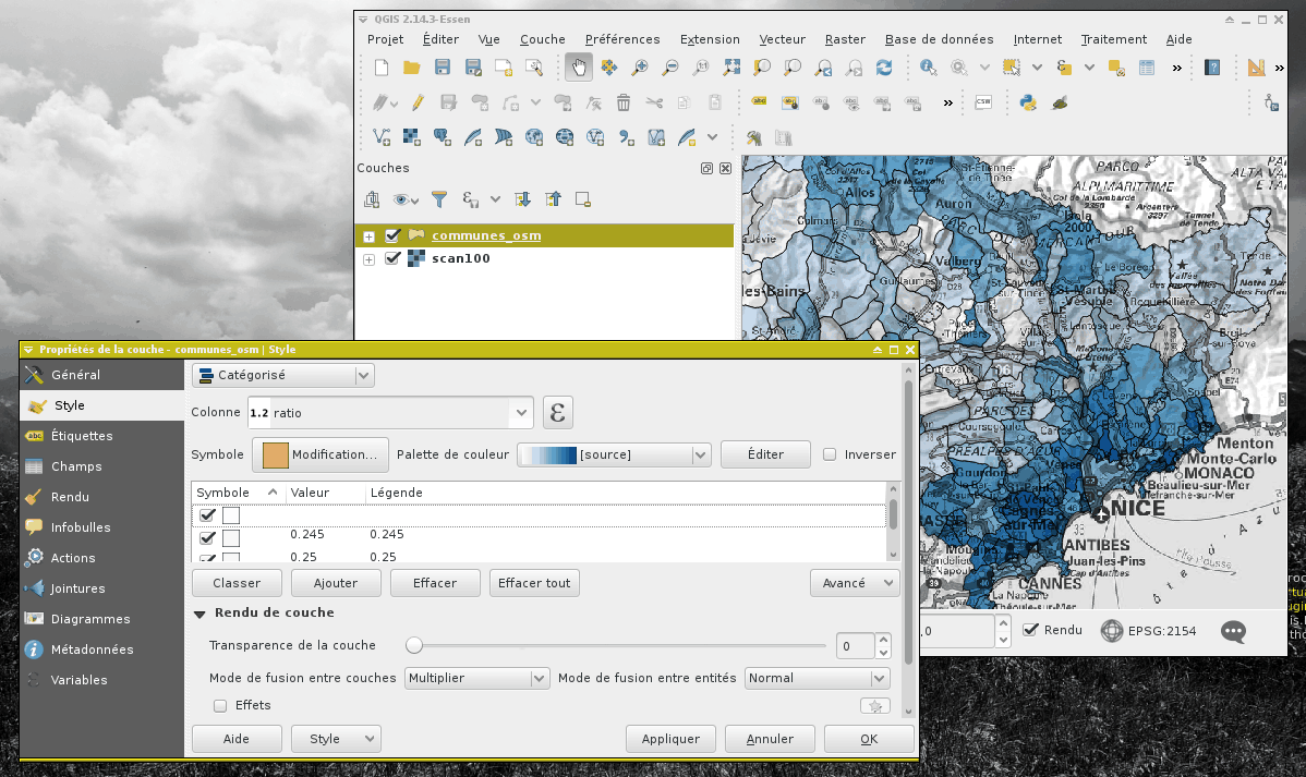
Checking Qgis 2.14 I see it was implemented (don't know for how long).
Screen capture shows a vector map (communes.osm) multiplied over a
greyscale raster.
V.
Le lundi 20 juin 2016 à 10:10 -0400, Vaclav Petras a écrit :
On Mon, Jun 20, 2016 at 10:05 AM, Anna Petrášová
<kratochanna@gmail.com> wrote:
> playing around with multiple layers in the map display I
wonder if
> anyone ever suggested to introduce blending modes beside the
already
> implemented "opacity" option. I mean it would be great to be
able to
there is r.blend as you probably know.
There is also d.his, d.rgb and d.shade.
(attachments)

On Mon, Jun 20, 2016 at 10:44 AM, Vincent Bain <bain@toraval.fr> wrote:
Indeed I was thinking of a process at the display driver level. This
would allow (am I wrong) to mix whatever kind of features (vector,
raster, labels, ...).
If I understand correctly, the general combination would be more
challenging and would have to implemented in GUI (you can create a ticket).
However, just for the rasters, d.shade probably covers significant part (or
all?) of the use cases. Note that there is also d.to.rast (not advertised
in the GUI but available in the console) which will save anything on the
display (vectors, labels, ...) as a raster map (so you can use d.shade
afterwards).
Le lundi 20 juin 2016 à 10:54 -0400, Vaclav Petras a écrit :
If I understand correctly, the general combination would be more
challenging and would have to implemented in GUI (you can create a
ticket). However, just for the rasters, d.shade probably covers
significant part (or all?) of the use cases.
yes
Note that there is also d.to.rast (not advertised in the GUI but
available in the console) which will save anything on the display
(vectors, labels, ...) as a raster map (so you can use d.shade
afterwards).
As I said some time ago
(https://lists.osgeo.org/pipermail/grass-user/2015-September/072982.html)
I cannot invoke d.to.rast to extract the map display content (only the
content of monitors activated via d.mon)... I may be missing something
about that.
in fact, for purely illustrative purpose, I usually proceed (a
quick&dirty way...) with sequential screen captures and blend them with
the Gimp.
