MarkusN wrote:
greetings from the amazing FOSS4G-CEE here in Bucharest
http://2013.foss4g-cee.org/program/schedule
and greetings back to all you meet there, 
will your history of geoFOSS slides go online?
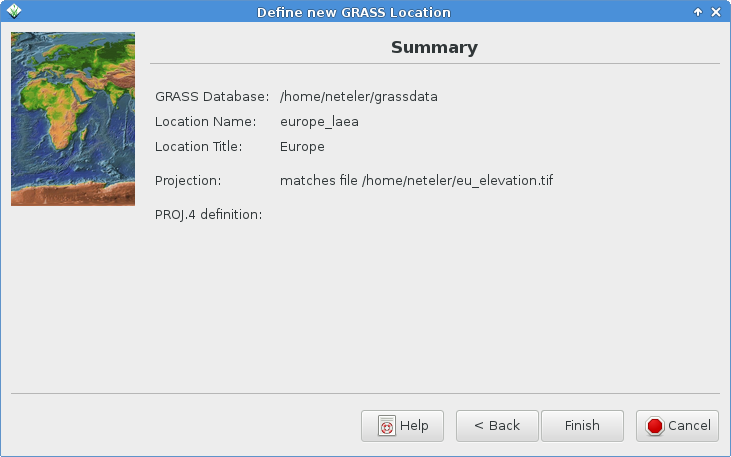
Preparing my slides I remembered an issue that the proj4 string is not
shown in case of generating a new location from a GeoTIFF (attached)
or SHP.
hmmm, I tested that a couple weeks ago and it was working, but now it doesn't
work for me using either your sample tiff or some I have locally. WKT & .prj
creation method similarly has no output in the summary page, same with .shp.
The locations are created ok though except I don't get prompted for datum
transform terms.
When using EPSG code as base for the new location this works fine.
I can of course open a ticket but perhaps it is just an "easy"
omission in the code.
Some tests:
gdalinfo shows:
{{{
PROJCS["Lambert Azimuthal Equal Area",
GEOGCS["GCS Name = grs80|Ellipsoid = Geodetic_Reference_System_1980|Primem = Greenwich|",
DATUM["European_Terrestrial_Reference_System_1989",
SPHEROID["GRS 1980",6378137,298.2572221010002,
AUTHORITY["EPSG","7019"]],
AUTHORITY["EPSG","6258"]],
PRIMEM["Greenwich",0],
UNIT["degree",0.0174532925199433]],
PROJECTION["Lambert_Azimuthal_Equal_Area"],
PARAMETER["latitude_of_center",52],
PARAMETER["longitude_of_center",10],
PARAMETER["false_easting",4321000],
PARAMETER["false_northing",3210000],
UNIT["metre",1,
AUTHORITY["EPSG","9001"]]]
}}}
here is a little shell script to create a .prj file from that:
{{{
GEOTIFF=eu_elevation.tif
TOP=`gdalinfo "$GEOTIFF" | grep -n -m 1 '^Coordinate System is:$' | cut -f1 -d:`
BOT=`gdalinfo "$GEOTIFF" | grep -n -m 1 '^Origin = ' | cut -f1 -d:`
BOT=`expr "$BOT" - 1`
LINES=`expr "$BOT" - "$TOP"`
gdalinfo "$GEOTIFF" | head -n "$BOT" | tail -n "$LINES" > `basename "$GEOTIFF" .tif`.prj
}}}
Is the first term of the above GEOGCS string legit or is it a r.out.gdal string error?
(it doesn't seem to be the problem though, with the other GeoTiff I had locally with
just "international" datum there, it still gave no +proj terms in the summary)
Using 'create new location from georef'd file' (latest 6.4.3svn) I end up with a
new location showing:
{{{
-PROJ_INFO-------------------------------------------------
name : Lambert Azimuthal Equal Area
proj : laea
datum : etrs89
ellps : grs80
lat_0 : 52
lon_0 : 10
x_0 : 4321000
y_0 : 3210000
no_defs : defined
-PROJ_UNITS------------------------------------------------
unit : metre
units : metres
meters : 1
}}}
which looks ok. I think the only data loss there is the Primem = Greenwich,
but that may just be left off as matching the default.
I'll have a look at the code... perhaps due to a glitch in the last commit there.
Hamish
