Hi all
I would like to calculate a geomorphic index for valley, using the following equation: height of the valley / width of the top of the valley - the higher the index values, the greater the notch (carve in the landscape) in the valley.
I found that SAGA gives the “Vertical distance to the channel network”.
Does GRASS have a function to calculate each ot the two input?
Thanks in advance
···
Cumprimentos,
Valter Albino - Geógrafo Físico, M.Sc.
Modelação H&H / Riscos ambientais / OT&U
www.valteralbino.wixsite.com/hydrodynamics
Hi Valter,
please have a look at:
https://grass.osgeo.org/grass78/manuals/addons/r.stream.distance.html
r.stream.distance - GRASS GIS manual
NAME r.stream.distance - Calculates distance to and elevation above streams and outlet. The module can work in stream mode where target are streams and outlets mode where targets are outlets. KEYWORDS raster, hydrology, stream network, watercourse distance SYNOPSIS
grass.osgeo.org
|
However, it is an addon. So it is - unfortunately - not necessarily straight forward to integrate it into your workflows (I understood you use GRASS from QGIS). At least in the processing framework you would need a workaround.
Hope that helps a bit never the less.
Cheers
Stefan
···
Fra: grass-user grass-user-bounces@lists.osgeo.org på vegne av Valter Albino valteralbino@gmail.com
Sendt: lørdag 11. april 2020 23:18
Til: grass-user grass-user@lists.osgeo.org
Emne: [GRASS-user] Geomorphic index for valley, using “height of the valley / width of the top of the valley”
Hi all
I would like to calculate a geomorphic index for valley, using the following equation: height of the valley / width of the top of the valley - the higher the index values, the greater the notch (carve in the landscape) in the valley.
I found that SAGA gives the “Vertical distance to the channel network”.
Does GRASS have a function to calculate each ot the two input?
Thanks in advance
Cumprimentos,
Valter Albino - Geógrafo Físico, M.Sc.
Modelação H&H / Riscos ambientais / OT&U
www.valteralbino.wixsite.com/hydrodynamics
Hi Stefan
Thanks for the answer.
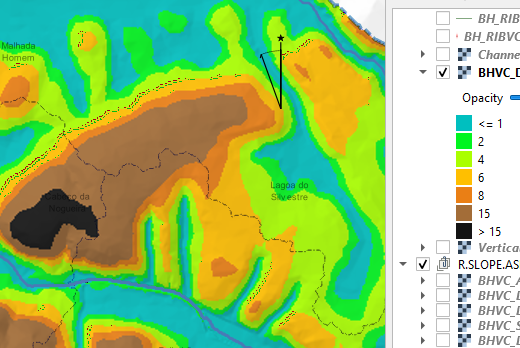
I tested in GRASS, but the results are not as expected. Selected the upstream calculation method and didn’t marked any option (optional tab). The vertical distance from stream to ridge line is not good and the crest of the valley is not correct. I did tested with SAGA the vertical distance from stream to ridge line along the watercourse and validated it manually (see image bellow).
In GRASS, the addon says:
(…)
difference
Name of output map of elevation difference to the target (outlet, node, stream, divide, maximum) along watercourse. The map is of DCELL type.
distance
Name of output map of distance to the target (outlet, node, stream, divide, maximum) along watercourse. The map is of DCELL type.
(…)
I thought that should it be possible to select the distance and difference from the stream to the divide (ridge line).
Well, it would be great if GRASS can do it.
Stefan Blumentrath <Stefan.Blumentrath@nina.no> escreveu no dia sábado, 11/04/2020 à(s) 22:57:
···
Cumprimentos,
Valter Albino - Geógrafo Físico, M.Sc.
Modelação H&H / Riscos ambientais / OT&U
www.valteralbino.wixsite.com/hydrodynamics