Hi
From r.sim.water, how can I calculate the volume of water stored in
small water storages placed along a relief and connected to ditches?
In this article https://doi.org/10.1016/j.agwat.2023.108398 these
Italian researchers with r.sim.water manage did this calculation, but I
do not understand how. With a calculation at different times on
discharge at the entrance to the water storage?
I tried to contact them, but they did not reply.
Thanks!
--
--
Perito agrario Enrico Gabrielli
progetto F.A.R.M. www.farm-agroecologia.it
Tessera n. 633 Collegio Periti agrari prov. Di Modena
Biblioteca agricoltura: https://www.zotero.org/groups/aplomb/
https://www.inaturalist.org/observations/bonushenricus
Hi and good sunday
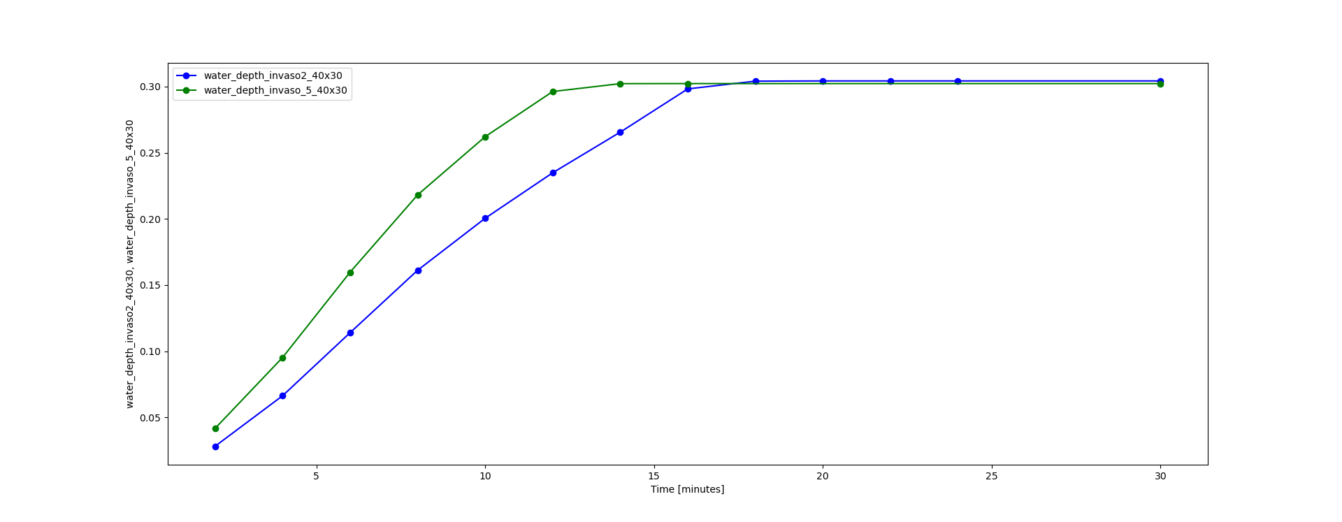
I attach the result of two small pond of this simulation:
the invaso2 is less a half surface area than the invaso5
They are in the same position in the watershed
I simulated a precipitation of 40 mm/hr x 30 minutes (!)
I aggregated with t.rast.aggregate method=sum granularity=30 (relative
time, timestamps of the r.sim.water -t are relative minutes)
the result at 30 minutes are
in invaso2 average of 2.91m
in invaso5 average of 1.97m
I expected the inverse,
so t.rast.aggregate method=sum with depth is not correct.
Thanks for some help
Il giorno dom, 30/07/2023 alle 12.01 +0200, bonushenricus ha scritto:
Hi
From r.sim.water, how can I calculate the volume of water stored in
small water storages placed along a relief and connected to ditches?
In this article https://doi.org/10.1016/j.agwat.2023.108398 these
Italian researchers with r.sim.water manage did this calculation, but
I
do not understand how. With a calculation at different times on
discharge at the entrance to the water storage?
I tried to contact them, but they did not reply.
Thanks!
--
(attachments)
Sorry
in fact temporal_plot_tool
when I export to csv
there is an interpolation
the sum result is
invaso2 2 meters
invaso5 2.2 meters
How I can calculate without temporal_plot_tool?
Il giorno dom, 30/07/2023 alle 19.01 +0200, bonushenricus ha scritto:
Hi and good sunday
I attach the result of two small pond of this simulation:
the invaso2 is less a half surface area than the invaso5
They are in the same position in the watershed
I simulated a precipitation of 40 mm/hr x 30 minutes (!)
I aggregated with t.rast.aggregate method=sum granularity=30
(relative
time, timestamps of the r.sim.water -t are relative minutes)
the result at 30 minutes are
in invaso2 average of 2.91m
in invaso5 average of 1.97m
I expected the inverse,
so t.rast.aggregate method=sum with depth is not correct.
Thanks for some help
Il giorno dom, 30/07/2023 alle 12.01 +0200, bonushenricus ha scritto:
> Hi
> From r.sim.water, how can I calculate the volume of water stored in
> small water storages placed along a relief and connected to
> ditches?
> In this article https://doi.org/10.1016/j.agwat.2023.108398 these
> Italian researchers with r.sim.water manage did this calculation,
> but
> I
> do not understand how. With a calculation at different times on
> discharge at the entrance to the water storage?
> I tried to contact them, but they did not reply.
> Thanks!
> --
On Sun, Jul 30, 2023 at 6:01 AM bonushenricus <bonushenricus76@gmail.com> wrote:
Hi
From r.sim.water, how can I calculate the volume of water stored in
small water storages placed along a relief and connected to ditches?
In this article https://doi.org/10.1016/j.agwat.2023.108398 these
Italian researchers with r.sim.water manage did this calculation, but I
do not understand how. With a calculation at different times on
discharge at the entrance to the water storage?
I tried to contact them, but they did not reply.
Thanks!
Hi,
volume would be simple depth times cell size squared for a certain selected area. I would compute it for the final step of the simulation, I am not sure what is the purpose of summing it for different time steps. Perhaps you could clarify a little bit?
Anna
–
Perito agrario Enrico Gabrielli
progetto F.A.R.M. www.farm-agroecologia.it
Tessera n. 633 Collegio Periti agrari prov. Di Modena
Biblioteca agricoltura: https://www.zotero.org/groups/aplomb/
https://www.inaturalist.org/observations/bonushenricus
grass-user mailing list
grass-user@lists.osgeo.org
https://lists.osgeo.org/mailman/listinfo/grass-user
Hi Anna
I too immediately thought it was enough to compute it for the final step of the simulation,
but I noticed that the same slope, same ditches, same rainfall, for two reservoirs at the same location, same length along a contour, but different width and depth, at the final step of the simulation the water depth was always 30 cm, I went to read the article
Mitasova, Helena, Chris Thaxton, Jaroslav Hofierka, Richard McLaughlin, Amber Moore, e Lubos Mitas. «Path Sampling Method for Modeling Overland Water Flow, Sediment Transport, and Short Term Terrain Evolution in Open Source GIS». In Developments in Water Science, 55:1479–90. Elsevier, 2004. https://doi.org/10.1016/S0167-5648(04)80159-X
where I read the Saint-Venant equation. I am an agricultural technician and geographer unfortunately ignorant of hydrological calculations and serious mathematics, and I understood, looking at the equation, that the water depth is the depth of overland flow = rainfall exces - water flow.
So the final 30 cm should not be understood as accumulated water, but as the blade of water that was added at that precise moment.
Isn’t my interpretation right?
--
--
Perito agrario Enrico Gabrielli
progetto F.A.R.M. www.farm-agroecologia.it
Tessera n. 633 Collegio Periti agrari prov. Di Modena
Biblioteca agricoltura: https://www.zotero.org/groups/aplomb/
https://www.inaturalist.org/observations/bonushenricus
Il giorno lun, 31/07/2023 alle 14.34 -0400, Anna Petrášová ha scritto:
On Sun, Jul 30, 2023 at 6:01 AM bonushenricus <bonushenricus76@gmail.com> wrote:
Hi
From r.sim.water, how can I calculate the volume of water stored in
small water storages placed along a relief and connected to ditches?
In this article https://doi.org/10.1016/j.agwat.2023.108398 these
Italian researchers with r.sim.water manage did this calculation, but I
do not understand how. With a calculation at different times on
discharge at the entrance to the water storage?
I tried to contact them, but they did not reply.
Thanks!
Hi,
volume would be simple depth times cell size squared for a certain selected area. I would compute it for the final step of the simulation, I am not sure what is the purpose of summing it for different time steps. Perhaps you could clarify a little bit?
Anna
–
On Mon, Jul 31, 2023 at 11:42 PM bonushenricus <bonushenricus76@gmail.com> wrote:
Hi Anna
I too immediately thought it was enough to compute it for the final step of the simulation,
but I noticed that the same slope, same ditches, same rainfall, for two reservoirs at the same location, same length along a contour, but different width and depth, at the final step of the simulation the water depth was always 30 cm, I went to read the article
Mitasova, Helena, Chris Thaxton, Jaroslav Hofierka, Richard McLaughlin, Amber Moore, e Lubos Mitas. «Path Sampling Method for Modeling Overland Water Flow, Sediment Transport, and Short Term Terrain Evolution in Open Source GIS». In Developments in Water Science, 55:1479–90. Elsevier, 2004. https://doi.org/10.1016/S0167-5648(04)80159-X
where I read the Saint-Venant equation. I am an agricultural technician and geographer unfortunately ignorant of hydrological calculations and serious mathematics, and I understood, looking at the equation, that the water depth is the depth of overland flow = rainfall exces - water flow.
So the final 30 cm should not be understood as accumulated water, but as the blade of water that was added at that precise moment.
Isn’t my interpretation right?
No, it should be actual water depth. I didn’t understand the discrepancy you are describing?
--
--
Perito agrario Enrico Gabrielli
progetto F.A.R.M. [www.farm-agroecologia.it](http://www.farm-agroecologia.it)
Tessera n. 633 Collegio Periti agrari prov. Di Modena
Biblioteca agricoltura: [https://www.zotero.org/groups/aplomb/](https://www.zotero.org/groups/aplomb/)
[https://www.inaturalist.org/observations/bonushenricus](https://www.inaturalist.org/observations/bonushenricus)
Il giorno lun, 31/07/2023 alle 14.34 -0400, Anna Petrášová ha scritto:
On Sun, Jul 30, 2023 at 6:01 AM bonushenricus <bonushenricus76@gmail.com> wrote:
Hi
From r.sim.water, how can I calculate the volume of water stored in
small water storages placed along a relief and connected to ditches?
In this article https://doi.org/10.1016/j.agwat.2023.108398 these
Italian researchers with r.sim.water manage did this calculation, but I
do not understand how. With a calculation at different times on
discharge at the entrance to the water storage?
I tried to contact them, but they did not reply.
Thanks!
Hi,
volume would be simple depth times cell size squared for a certain selected area. I would compute it for the final step of the simulation, I am not sure what is the purpose of summing it for different time steps. Perhaps you could clarify a little bit?
Anna
–
Thank you, Anna.
r.sim.water finishes the simulation not at the end of the rainfall event, in my case at 30 minutes, but at an earlier time. In my case, in the smaller reservoir at 16 minutes, in the case of the more extensive reservoir at 24 minutes. But the water keeps coming even after that. I imagined that the calculation ends when it reaches the steady state of the water blade.
But it’s not so. Then I don’t understand why it ends at 16 or 24 minutes. Doesn’t the water continue to arrive after that? Shouldn’t it increase?
I cannot understand it. In the reservoirs, the discharge is very low, as I expect. But if the discharge does not increase and the precipitation continues, I expect the water depth to rise again.
And it is not understandable that two reservoirs, one twice the volume of the other, contain the same depth of 30 cm at the end of the rainfall.
To understand how this works, I would apply waterproofing to the reservoirs. The ksat, or infil_value, is the only variable that can explain this: the larger reservoir loses more water.
If both reservoirs were waterproof, I would have removed this variable. Unfortunately r.sim.water infil=raster where I have marked value 0 in the reservoirs does not work. There is perhaps a bug that I have reported. So I haven’t had a chance to test this.
I don’t know how to do it; I can’t trust the 30 cm as a value to calculate the water volume in the two reservoirs. I will have to use another model.
I will try to use a distributed model. Since I have the data in GRASS, I will try using the old geomhydas, hoping the modules will work in GRASS8, and then use the Mhydas models in OpenFluid. I have no other chance unless someone can help me find a solution.
--
--
Perito agrario Enrico Gabrielli
progetto F.A.R.M. www.farm-agroecologia.it
Tessera n. 633 Collegio Periti agrari prov. Di Modena
Biblioteca agricoltura: https://www.zotero.org/groups/aplomb/
https://www.inaturalist.org/observations/bonushenricus
Il giorno mar, 01/08/2023 alle 09.23 -0400, Anna Petrášová ha scritto:
On Mon, Jul 31, 2023 at 11:42 PM bonushenricus <bonushenricus76@gmail.com> wrote:
Hi Anna
I too immediately thought it was enough to compute it for the final step of the simulation,
but I noticed that the same slope, same ditches, same rainfall, for two reservoirs at the same location, same length along a contour, but different width and depth, at the final step of the simulation the water depth was always 30 cm, I went to read the article
Mitasova, Helena, Chris Thaxton, Jaroslav Hofierka, Richard McLaughlin, Amber Moore, e Lubos Mitas. «Path Sampling Method for Modeling Overland Water Flow, Sediment Transport, and Short Term Terrain Evolution in Open Source GIS». In Developments in Water Science, 55:1479–90. Elsevier, 2004. https://doi.org/10.1016/S0167-5648(04)80159-X
where I read the Saint-Venant equation. I am an agricultural technician and geographer unfortunately ignorant of hydrological calculations and serious mathematics, and I understood, looking at the equation, that the water depth is the depth of overland flow = rainfall exces - water flow.
So the final 30 cm should not be understood as accumulated water, but as the blade of water that was added at that precise moment.
Isn’t my interpretation right?
No, it should be actual water depth. I didn’t understand the discrepancy you are describing?
--
--
Perito agrario Enrico Gabrielli
progetto F.A.R.M. [www.farm-agroecologia.it](http://www.farm-agroecologia.it)
Tessera n. 633 Collegio Periti agrari prov. Di Modena
Biblioteca agricoltura: [https://www.zotero.org/groups/aplomb/](https://www.zotero.org/groups/aplomb/)
[https://www.inaturalist.org/observations/bonushenricus](https://www.inaturalist.org/observations/bonushenricus)
Il giorno lun, 31/07/2023 alle 14.34 -0400, Anna Petrášová ha scritto:
On Sun, Jul 30, 2023 at 6:01 AM bonushenricus <bonushenricus76@gmail.com> wrote:
Hi
From r.sim.water, how can I calculate the volume of water stored in
small water storages placed along a relief and connected to ditches?
In this article https://doi.org/10.1016/j.agwat.2023.108398 these
Italian researchers with r.sim.water manage did this calculation, but I
do not understand how. With a calculation at different times on
discharge at the entrance to the water storage?
I tried to contact them, but they did not reply.
Thanks!
Hi,
volume would be simple depth times cell size squared for a certain selected area. I would compute it for the final step of the simulation, I am not sure what is the purpose of summing it for different time steps. Perhaps you could clarify a little bit?
Anna
Sorry
I was too impetuous.
I have to think about it more calmly.
In fact, I am too ignorant on the subject.
If it were the water blade, it wouldn’t make sense for it to grow faster in case of the smaller reservoir.
But I would expect, in my logic, that the water depth would again grow in the smaller reservoir.
I will do more tests, try to understand. Or maybe the model is not adapted to the presence of small ponds. Consider that these are 30 and 70 m³ ponds, very small indeed.
--
--
Perito agrario Enrico Gabrielli
progetto F.A.R.M. www.farm-agroecologia.it
Tessera n. 633 Collegio Periti agrari prov. Di Modena
Biblioteca agricoltura: https://www.zotero.org/groups/aplomb/
https://www.inaturalist.org/observations/bonushenricus
Il giorno mar, 01/08/2023 alle 16.23 +0200, bonushenricus ha scritto:
Thank you, Anna.
r.sim.water finishes the simulation not at the end of the rainfall event, in my case at 30 minutes, but at an earlier time. In my case, in the smaller reservoir at 16 minutes, in the case of the more extensive reservoir at 24 minutes. But the water keeps coming even after that. I imagined that the calculation ends when it reaches the steady state of the water blade.
But it’s not so. Then I don’t understand why it ends at 16 or 24 minutes. Doesn’t the water continue to arrive after that? Shouldn’t it increase?
I cannot understand it. In the reservoirs, the discharge is very low, as I expect. But if the discharge does not increase and the precipitation continues, I expect the water depth to rise again.
And it is not understandable that two reservoirs, one twice the volume of the other, contain the same depth of 30 cm at the end of the rainfall.
To understand how this works, I would apply waterproofing to the reservoirs. The ksat, or infil_value, is the only variable that can explain this: the larger reservoir loses more water.
If both reservoirs were waterproof, I would have removed this variable. Unfortunately r.sim.water infil=raster where I have marked value 0 in the reservoirs does not work. There is perhaps a bug that I have reported. So I haven’t had a chance to test this.
I don’t know how to do it; I can’t trust the 30 cm as a value to calculate the water volume in the two reservoirs. I will have to use another model.
I will try to use a distributed model. Since I have the data in GRASS, I will try using the old geomhydas, hoping the modules will work in GRASS8, and then use the Mhydas models in OpenFluid. I have no other chance unless someone can help me find a solution.
--
--
Perito agrario Enrico Gabrielli
progetto F.A.R.M. www.farm-agroecologia.it
Tessera n. 633 Collegio Periti agrari prov. Di Modena
Biblioteca agricoltura: https://www.zotero.org/groups/aplomb/
https://www.inaturalist.org/observations/bonushenricus
Il giorno mar, 01/08/2023 alle 09.23 -0400, Anna Petrášová ha scritto:
On Mon, Jul 31, 2023 at 11:42 PM bonushenricus <bonushenricus76@gmail.com> wrote:
Hi Anna
I too immediately thought it was enough to compute it for the final step of the simulation,
but I noticed that the same slope, same ditches, same rainfall, for two reservoirs at the same location, same length along a contour, but different width and depth, at the final step of the simulation the water depth was always 30 cm, I went to read the article
Mitasova, Helena, Chris Thaxton, Jaroslav Hofierka, Richard McLaughlin, Amber Moore, e Lubos Mitas. «Path Sampling Method for Modeling Overland Water Flow, Sediment Transport, and Short Term Terrain Evolution in Open Source GIS». In Developments in Water Science, 55:1479–90. Elsevier, 2004. https://doi.org/10.1016/S0167-5648(04)80159-X
where I read the Saint-Venant equation. I am an agricultural technician and geographer unfortunately ignorant of hydrological calculations and serious mathematics, and I understood, looking at the equation, that the water depth is the depth of overland flow = rainfall exces - water flow.
So the final 30 cm should not be understood as accumulated water, but as the blade of water that was added at that precise moment.
Isn’t my interpretation right?
No, it should be actual water depth. I didn’t understand the discrepancy you are describing?
--
On Tue, Aug 1, 2023 at 10:23 AM bonushenricus <bonushenricus76@gmail.com> wrote:
Thank you, Anna.
r.sim.water finishes the simulation not at the end of the rainfall event, in my case at 30 minutes, but at an earlier time. In my case, in the smaller reservoir at 16 minutes, in the case of the more extensive reservoir at 24 minutes. But the water keeps coming even after that. I imagined that the calculation ends when it reaches the steady state of the water blade.
But it’s not so. Then I don’t understand why it ends at 16 or 24 minutes. Doesn’t the water continue to arrive after that? Shouldn’t it increase?
I cannot understand it. In the reservoirs, the discharge is very low, as I expect. But if the discharge does not increase and the precipitation continues, I expect the water depth to rise again.
And it is not understandable that two reservoirs, one twice the volume of the other, contain the same depth of 30 cm at the end of the rainfall.
To understand how this works, I would apply waterproofing to the reservoirs. The ksat, or infil_value, is the only variable that can explain this: the larger reservoir loses more water.
If both reservoirs were waterproof, I would have removed this variable. Unfortunately r.sim.water infil=raster where I have marked value 0 in the reservoirs does not work. There is perhaps a bug that I have reported. So I haven’t had a chance to test this.
I don’t know how to do it; I can’t trust the 30 cm as a value to calculate the water volume in the two reservoirs. I will have to use another model.
I will try to use a distributed model. Since I have the data in GRASS, I will try using the old geomhydas, hoping the modules will work in GRASS8, and then use the Mhydas models in OpenFluid. I have no other chance unless someone can help me find a solution.
Unfortunately I haven’t had time to look at the reported issue. Perhaps you could share your data and provide exact commands and pictures, explaining very clearly what’s wrong.
--
--
Perito agrario Enrico Gabrielli
progetto F.A.R.M. [www.farm-agroecologia.it](http://www.farm-agroecologia.it)
Tessera n. 633 Collegio Periti agrari prov. Di Modena
Biblioteca agricoltura: [https://www.zotero.org/groups/aplomb/](https://www.zotero.org/groups/aplomb/)
[https://www.inaturalist.org/observations/bonushenricus](https://www.inaturalist.org/observations/bonushenricus)
Il giorno mar, 01/08/2023 alle 09.23 -0400, Anna Petrášová ha scritto:
On Mon, Jul 31, 2023 at 11:42 PM bonushenricus <bonushenricus76@gmail.com> wrote:
Hi Anna
I too immediately thought it was enough to compute it for the final step of the simulation,
but I noticed that the same slope, same ditches, same rainfall, for two reservoirs at the same location, same length along a contour, but different width and depth, at the final step of the simulation the water depth was always 30 cm, I went to read the article
Mitasova, Helena, Chris Thaxton, Jaroslav Hofierka, Richard McLaughlin, Amber Moore, e Lubos Mitas. «Path Sampling Method for Modeling Overland Water Flow, Sediment Transport, and Short Term Terrain Evolution in Open Source GIS». In Developments in Water Science, 55:1479–90. Elsevier, 2004. https://doi.org/10.1016/S0167-5648(04)80159-X
where I read the Saint-Venant equation. I am an agricultural technician and geographer unfortunately ignorant of hydrological calculations and serious mathematics, and I understood, looking at the equation, that the water depth is the depth of overland flow = rainfall exces - water flow.
So the final 30 cm should not be understood as accumulated water, but as the blade of water that was added at that precise moment.
Isn’t my interpretation right?
No, it should be actual water depth. I didn’t understand the discrepancy you are describing?
--
--
Perito agrario Enrico Gabrielli
progetto F.A.R.M. [www.farm-agroecologia.it](http://www.farm-agroecologia.it)
Tessera n. 633 Collegio Periti agrari prov. Di Modena
Biblioteca agricoltura: [https://www.zotero.org/groups/aplomb/](https://www.zotero.org/groups/aplomb/)
[https://www.inaturalist.org/observations/bonushenricus](https://www.inaturalist.org/observations/bonushenricus)
Il giorno lun, 31/07/2023 alle 14.34 -0400, Anna Petrášová ha scritto:
On Sun, Jul 30, 2023 at 6:01 AM bonushenricus <bonushenricus76@gmail.com> wrote:
Hi
From r.sim.water, how can I calculate the volume of water stored in
small water storages placed along a relief and connected to ditches?
In this article https://doi.org/10.1016/j.agwat.2023.108398 these
Italian researchers with r.sim.water manage did this calculation, but I
do not understand how. With a calculation at different times on
discharge at the entrance to the water storage?
I tried to contact them, but they did not reply.
Thanks!
Hi,
volume would be simple depth times cell size squared for a certain selected area. I would compute it for the final step of the simulation, I am not sure what is the purpose of summing it for different time steps. Perhaps you could clarify a little bit?
Anna
On Tue, 1 Aug 2023 at 10:24, bonushenricus <bonushenricus76@gmail.com> wrote:
Since I have the data in GRASS, I will try using the old geomhydas, hoping the modules will work in GRASS8, and then use the Mhydas models in OpenFluid.
I don’t know anything about Geo-MHYDAS, but a lot of effort in GRASS GIS goes into compatibility, so I would hope you can make it work. Anyway sometimes breaking changes are needed and Geo-MHYDAS is definitively written in an older style, namely with long Bash scripts with Perl helpers, but that doesn’t really matter for GRASS version compatibility as long as you are on Linux.
https://github.com/UMR-LISAH/Geo-MHYDAS-2010
Thank you Anna.
I will try to attach the two geotiffs in a compressed folder, with the simplest example of a single ditch, for both reservoirs. EPSG:32632.
The ditch is not exactly the same for the two reservoirs, they change a little bit in the final part of the mouth of the reservoir, but it is very similar.
Sorry I didn’t use a sample vector of points, I did it later with temporal.
r.slope.aspect elevation=dem_invaso2 dx=dx_invaso2 dy=dy_invaso2
r.sim.water -t elevation=dem_invaso2 dx=dx_invaso2 dy=dy_invaso2 rain_value=40 infil_value=24.1 man_value=0.368 depth=water_depth_invaso2_40x30mm discharge=discharge_invaso2_40x30mm niterations=30 --overwrite
r.slope.aspect elevation=dem_invaso6 dx=dx_invaso6 dy=dy_invaso6
r.sim.water -t elevation=dem_invaso6 dx=dx_invaso6 dy=dy_invaso6 rain_value=40 infil_value=24.1 man_value=0.368 depth=water_depth_invaso6_40x30mm discharge=discharge_invaso6_40x30mm niterations=30 --overwrite
Thank you very much
I am sure there is some mistake on my part!
--
--
Perito agrario Enrico Gabrielli
progetto F.A.R.M. [www.farm-agroecologia.it](https://www.farm-agroecologia.it)
Tessera n. 633 Collegio Periti agrari prov. Di Modena
Biblioteca agricoltura: [https://www.zotero.org/groups/aplomb/](https://www.zotero.org/groups/aplomb/)
[https://www.inaturalist.org/observations/bonushenricus](https://www.inaturalist.org/observations/bonushenricus)
Il giorno mar, 01/08/2023 alle 13.17 -0400, Anna Petrášová ha scritto:
On Tue, Aug 1, 2023 at 10:23 AM bonushenricus <bonushenricus76@gmail.com> wrote:
Thank you, Anna.
r.sim.water finishes the simulation not at the end of the rainfall event, in my case at 30 minutes, but at an earlier time. In my case, in the smaller reservoir at 16 minutes, in the case of the more extensive reservoir at 24 minutes. But the water keeps coming even after that. I imagined that the calculation ends when it reaches the steady state of the water blade.
But it’s not so. Then I don’t understand why it ends at 16 or 24 minutes. Doesn’t the water continue to arrive after that? Shouldn’t it increase?
I cannot understand it. In the reservoirs, the discharge is very low, as I expect. But if the discharge does not increase and the precipitation continues, I expect the water depth to rise again.
And it is not understandable that two reservoirs, one twice the volume of the other, contain the same depth of 30 cm at the end of the rainfall.
To understand how this works, I would apply waterproofing to the reservoirs. The ksat, or infil_value, is the only variable that can explain this: the larger reservoir loses more water.
If both reservoirs were waterproof, I would have removed this variable. Unfortunately r.sim.water infil=raster where I have marked value 0 in the reservoirs does not work. There is perhaps a bug that I have reported. So I haven’t had a chance to test this.
I don’t know how to do it; I can’t trust the 30 cm as a value to calculate the water volume in the two reservoirs. I will have to use another model.
I will try to use a distributed model. Since I have the data in GRASS, I will try using the old geomhydas, hoping the modules will work in GRASS8, and then use the Mhydas models in OpenFluid. I have no other chance unless someone can help me find a solution.
Unfortunately I haven’t had time to look at the reported issue. Perhaps you could share your data and provide exact commands and pictures, explaining very clearly what’s wrong.
--
--
Perito agrario Enrico Gabrielli
progetto F.A.R.M. [www.farm-agroecologia.it](http://www.farm-agroecologia.it)
Tessera n. 633 Collegio Periti agrari prov. Di Modena
Biblioteca agricoltura: [https://www.zotero.org/groups/aplomb/](https://www.zotero.org/groups/aplomb/)
[https://www.inaturalist.org/observations/bonushenricus](https://www.inaturalist.org/observations/bonushenricus)
Il giorno mar, 01/08/2023 alle 09.23 -0400, Anna Petrášová ha scritto:
On Mon, Jul 31, 2023 at 11:42 PM bonushenricus <bonushenricus76@gmail.com> wrote:
Hi Anna
I too immediately thought it was enough to compute it for the final step of the simulation,
but I noticed that the same slope, same ditches, same rainfall, for two reservoirs at the same location, same length along a contour, but different width and depth, at the final step of the simulation the water depth was always 30 cm, I went to read the article
Mitasova, Helena, Chris Thaxton, Jaroslav Hofierka, Richard McLaughlin, Amber Moore, e Lubos Mitas. «Path Sampling Method for Modeling Overland Water Flow, Sediment Transport, and Short Term Terrain Evolution in Open Source GIS». In Developments in Water Science, 55:1479–90. Elsevier, 2004. https://doi.org/10.1016/S0167-5648(04)80159-X
where I read the Saint-Venant equation. I am an agricultural technician and geographer unfortunately ignorant of hydrological calculations and serious mathematics, and I understood, looking at the equation, that the water depth is the depth of overland flow = rainfall exces - water flow.
So the final 30 cm should not be understood as accumulated water, but as the blade of water that was added at that precise moment.
Isn’t my interpretation right?
No, it should be actual water depth. I didn’t understand the discrepancy you are describing?
--
(attachments)
reservoir_farm_granello.tar.bz2 (2.4 MB)
Hello Enrico:
Anna knows this subject better than I do, but I noticed a few problems with your command, so here are some comments that might help to get a better result.
First, your man_value is way too high. You probably want something like 0.03
Second, you are using the ‘-t’ flag but no output_step, If you add output_step of a few minutes, then you should get multiple output rasters at each time step.
Third, you have 40 mm/hr rain_rate and 24.1 mm/hr infiltration rate. Is that correct? That means that 60% of the rain is infiltrating throughout the 30 minute storm. This might happen in very dry and sandy soil. Is that your situation?
Here’s what I tried (changing the above 3 parameters):
r.external ./reservoir_farm_granello/dem_invaso2.tif output=dem_2
g.region -ap rast=dem_2
r.slope.aspect elevation=dem_2 dx=dx_2 dy=dy_2
r.sim.water -t elevation=dem_2 dx=dx_2 dy=dy_2 rain_value=40 infil_value=15 man_value=0.0368 depth=water_depth_invaso2_40x30mm discharge=discharge_invaso2_40x30mm niterations=30 output_step=5 random_seed=42 nprocs=8 --overwrite
This resulted in 5 depth (and 5 discharge) rasters. For example:
r.univar water_depth_invaso2_40x30mm.05
100%
total null and non-null cells: 1197120
total null cells: 667811
Of the non-null cells:
(attachments)
···
On 01/08/2023 21:35, bonushenricus wrote:
Thank you Anna.
I will try to attach the two geotiffs in a compressed folder, with the simplest example of a single ditch, for both reservoirs. EPSG:32632.
The ditch is not exactly the same for the two reservoirs, they change a little bit in the final part of the mouth of the reservoir, but it is very similar.
Sorry I didn’t use a sample vector of points, I did it later with temporal.
r.slope.aspect elevation=dem_invaso2 dx=dx_invaso2 dy=dy_invaso2
r.sim.water -t elevation=dem_invaso2 dx=dx_invaso2 dy=dy_invaso2 rain_value=40 infil_value=24.1 man_value=0.368 depth=water_depth_invaso2_40x30mm discharge=discharge_invaso2_40x30mm niterations=30 --overwrite
r.slope.aspect elevation=dem_invaso6 dx=dx_invaso6 dy=dy_invaso6
r.sim.water -t elevation=dem_invaso6 dx=dx_invaso6 dy=dy_invaso6 rain_value=40 infil_value=24.1 man_value=0.368 depth=water_depth_invaso6_40x30mm discharge=discharge_invaso6_40x30mm niterations=30 --overwrite
Thank you very much
I am sure there is some mistake on my part!
--
--
Perito agrario Enrico Gabrielli
progetto F.A.R.M. [www.farm-agroecologia.it](https://www.farm-agroecologia.it)
Tessera n. 633 Collegio Periti agrari prov. Di Modena
Biblioteca agricoltura: [https://www.zotero.org/groups/aplomb/](https://www.zotero.org/groups/aplomb/)
[https://www.inaturalist.org/observations/bonushenricus](https://www.inaturalist.org/observations/bonushenricus)
Il giorno mar, 01/08/2023 alle 13.17 -0400, Anna Petrášová ha scritto:
On Tue, Aug 1, 2023 at 10:23 AM bonushenricus <bonushenricus76@gmail.com> wrote:
Thank you, Anna.
r.sim.water finishes the simulation not at the end of the rainfall event, in my case at 30 minutes, but at an earlier time. In my case, in the smaller reservoir at 16 minutes, in the case of the more extensive reservoir at 24 minutes. But the water keeps coming even after that. I imagined that the calculation ends when it reaches the steady state of the water blade.
But it’s not so. Then I don’t understand why it ends at 16 or 24 minutes. Doesn’t the water continue to arrive after that? Shouldn’t it increase?
I cannot understand it. In the reservoirs, the discharge is very low, as I expect. But if the discharge does not increase and the precipitation continues, I expect the water depth to rise again.
And it is not understandable that two reservoirs, one twice the volume of the other, contain the same depth of 30 cm at the end of the rainfall.
To understand how this works, I would apply waterproofing to the reservoirs. The ksat, or infil_value, is the only variable that can explain this: the larger reservoir loses more water.
If both reservoirs were waterproof, I would have removed this variable. Unfortunately r.sim.water infil=raster where I have marked value 0 in the reservoirs does not work. There is perhaps a bug that I have reported. So I haven’t had a chance to test this.
I don’t know how to do it; I can’t trust the 30 cm as a value to calculate the water volume in the two reservoirs. I will have to use another model.
I will try to use a distributed model. Since I have the data in GRASS, I will try using the old geomhydas, hoping the modules will work in GRASS8, and then use the Mhydas models in OpenFluid. I have no other chance unless someone can help me find a solution.
Unfortunately I haven’t had time to look at the reported issue. Perhaps you could share your data and provide exact commands and pictures, explaining very clearly what’s wrong.
--
--
Perito agrario Enrico Gabrielli
progetto F.A.R.M. [www.farm-agroecologia.it](http://www.farm-agroecologia.it)
Tessera n. 633 Collegio Periti agrari prov. Di Modena
Biblioteca agricoltura: [https://www.zotero.org/groups/aplomb/](https://www.zotero.org/groups/aplomb/)
[https://www.inaturalist.org/observations/bonushenricus](https://www.inaturalist.org/observations/bonushenricus)
Il giorno mar, 01/08/2023 alle 09.23 -0400, Anna Petrášová ha scritto:
On Mon, Jul 31, 2023 at 11:42 PM bonushenricus <bonushenricus76@gmail.com> wrote:
Hi Anna
I too immediately thought it was enough to compute it for the final step of the simulation,
but I noticed that the same slope, same ditches, same rainfall, for two reservoirs at the same location, same length along a contour, but different width and depth, at the final step of the simulation the water depth was always 30 cm, I went to read the article
Mitasova, Helena, Chris Thaxton, Jaroslav Hofierka, Richard McLaughlin, Amber Moore, e Lubos Mitas. «Path Sampling Method for Modeling Overland Water Flow, Sediment Transport, and Short Term Terrain Evolution in Open Source GIS». In Developments in Water Science, 55:1479–90. Elsevier, 2004. https://doi.org/10.1016/S0167-5648(04)80159-X
where I read the Saint-Venant equation. I am an agricultural technician and geographer unfortunately ignorant of hydrological calculations and serious mathematics, and I understood, looking at the equation, that the water depth is the depth of overland flow = rainfall exces - water flow.
So the final 30 cm should not be understood as accumulated water, but as the blade of water that was added at that precise moment.
Isn’t my interpretation right?
No, it should be actual water depth. I didn’t understand the discrepancy you are describing?
--
_______________________________________________
grass-user mailing list
[grass-user@lists.osgeo.org](mailto:grass-user@lists.osgeo.org)
[https://lists.osgeo.org/mailman/listinfo/grass-user](https://lists.osgeo.org/mailman/listinfo/grass-user)
--
Micha Silver
Ben Gurion Univ.
Sde Boker, Remote Sensing Lab
cell: +972-523-665918
Thanks Micha
What a mistake with Manning’s coefficient! I took off a zero!
For infil: the soil is sandy. The 24.1 mm/h is taken from the soil map with published regional data. There are two reference sites in the area of soil delineation: 48% sand and 22% clay: 7.7 mm/h; 52% sand, 14% clay: 24.1 mm/h. If I can, I will go and measure on the ground. But for now, maybe 15 might be good.
The result, however, still doesn’t convince me.
If I try the simulation on “invaso6”, with the same parameters as “invaso2”, it ends after 10 minutes with a result of 30 cm.
···
On 01/08/2023 21:35, bonushenricus wrote:
Thank you Anna.
I will try to attach the two geotiffs in a compressed folder, with the simplest example of a single ditch, for both reservoirs. EPSG:32632.
The ditch is not exactly the same for the two reservoirs, they change a little bit in the final part of the mouth of the reservoir, but it is very similar.
Sorry I didn’t use a sample vector of points, I did it later with temporal.
r.slope.aspect elevation=dem_invaso2 dx=dx_invaso2 dy=dy_invaso2
r.sim.water -t elevation=dem_invaso2 dx=dx_invaso2 dy=dy_invaso2 rain_value=40 infil_value=24.1 man_value=0.368 depth=water_depth_invaso2_40x30mm discharge=discharge_invaso2_40x30mm niterations=30 --overwrite
r.slope.aspect elevation=dem_invaso6 dx=dx_invaso6 dy=dy_invaso6
r.sim.water -t elevation=dem_invaso6 dx=dx_invaso6 dy=dy_invaso6 rain_value=40 infil_value=24.1 man_value=0.368 depth=water_depth_invaso6_40x30mm discharge=discharge_invaso6_40x30mm niterations=30 --overwrite
Thank you very much
I am sure there is some mistake on my part!
--
--
Perito agrario Enrico Gabrielli
progetto F.A.R.M. [www.farm-agroecologia.it](https://www.farm-agroecologia.it)
Tessera n. 633 Collegio Periti agrari prov. Di Modena
Biblioteca agricoltura: [https://www.zotero.org/groups/aplomb/](https://www.zotero.org/groups/aplomb/)
[https://www.inaturalist.org/observations/bonushenricus](https://www.inaturalist.org/observations/bonushenricus)
Il giorno mar, 01/08/2023 alle 13.17 -0400, Anna Petrášová ha scritto:
On Tue, Aug 1, 2023 at 10:23 AM bonushenricus <bonushenricus76@gmail.com> wrote:
Thank you, Anna.
r.sim.water finishes the simulation not at the end of the rainfall event, in my case at 30 minutes, but at an earlier time. In my case, in the smaller reservoir at 16 minutes, in the case of the more extensive reservoir at 24 minutes. But the water keeps coming even after that. I imagined that the calculation ends when it reaches the steady state of the water blade.
But it’s not so. Then I don’t understand why it ends at 16 or 24 minutes. Doesn’t the water continue to arrive after that? Shouldn’t it increase?
I cannot understand it. In the reservoirs, the discharge is very low, as I expect. But if the discharge does not increase and the precipitation continues, I expect the water depth to rise again.
And it is not understandable that two reservoirs, one twice the volume of the other, contain the same depth of 30 cm at the end of the rainfall.
To understand how this works, I would apply waterproofing to the reservoirs. The ksat, or infil_value, is the only variable that can explain this: the larger reservoir loses more water.
If both reservoirs were waterproof, I would have removed this variable. Unfortunately r.sim.water infil=raster where I have marked value 0 in the reservoirs does not work. There is perhaps a bug that I have reported. So I haven’t had a chance to test this.
I don’t know how to do it; I can’t trust the 30 cm as a value to calculate the water volume in the two reservoirs. I will have to use another model.
I will try to use a distributed model. Since I have the data in GRASS, I will try using the old geomhydas, hoping the modules will work in GRASS8, and then use the Mhydas models in OpenFluid. I have no other chance unless someone can help me find a solution.
Unfortunately I haven’t had time to look at the reported issue. Perhaps you could share your data and provide exact commands and pictures, explaining very clearly what’s wrong.
--
--
Perito agrario Enrico Gabrielli
progetto F.A.R.M. [www.farm-agroecologia.it](http://www.farm-agroecologia.it)
Tessera n. 633 Collegio Periti agrari prov. Di Modena
Biblioteca agricoltura: [https://www.zotero.org/groups/aplomb/](https://www.zotero.org/groups/aplomb/)
[https://www.inaturalist.org/observations/bonushenricus](https://www.inaturalist.org/observations/bonushenricus)
Il giorno mar, 01/08/2023 alle 09.23 -0400, Anna Petrášová ha scritto:
On Mon, Jul 31, 2023 at 11:42 PM bonushenricus <bonushenricus76@gmail.com> wrote:
Hi Anna
I too immediately thought it was enough to compute it for the final step of the simulation,
but I noticed that the same slope, same ditches, same rainfall, for two reservoirs at the same location, same length along a contour, but different width and depth, at the final step of the simulation the water depth was always 30 cm, I went to read the article
Mitasova, Helena, Chris Thaxton, Jaroslav Hofierka, Richard McLaughlin, Amber Moore, e Lubos Mitas. «Path Sampling Method for Modeling Overland Water Flow, Sediment Transport, and Short Term Terrain Evolution in Open Source GIS». In Developments in Water Science, 55:1479–90. Elsevier, 2004. https://doi.org/10.1016/S0167-5648(04)80159-X
where I read the Saint-Venant equation. I am an agricultural technician and geographer unfortunately ignorant of hydrological calculations and serious mathematics, and I understood, looking at the equation, that the water depth is the depth of overland flow = rainfall exces - water flow.
So the final 30 cm should not be understood as accumulated water, but as the blade of water that was added at that precise moment.
Isn’t my interpretation right?
No, it should be actual water depth. I didn’t understand the discrepancy you are describing?
--
_______________________________________________
grass-user mailing list
[grass-user@lists.osgeo.org](mailto:grass-user@lists.osgeo.org)
[https://lists.osgeo.org/mailman/listinfo/grass-user](https://lists.osgeo.org/mailman/listinfo/grass-user)
Hello
I made two better digital elevation models for my tests, here attached.
There are two designs, each with a pond about 1 metre deep, the same position on the slope, and two ditches reaching the pond.
One design has a pond with a surface area of 63m², and the other has a surface area of 131m², with a depth of about 1 metre, with a volume of 52m³ and 118m³, respectively.
I expect that having the same slope and ditches upstream, the two ponds will be filled with a similar volume of water.
Seen infil_rast for make waterproof the ponds doesn’t run, I tried using flow_control, and it work.
And I tried with hmax=1
Here the “script” (after import geotiff attached)
r.lake --overwrite elevation=dem_pondB water_level=480.7 lake=pondB coordinates=687064.2576117209,4910526.453118301
#results 118m³ 131m²
r.lake --overwrite elevation=dem_pondA water_level=480.9 lake=pondA coordinates=687064.2576117209,4910526.453118301
#results 52m³ 63m²
r.mapcalc expression=“flow_control_pondA = if(pondA,0)” --overwrite
r.mapcalc expression=“flow_control_pondB = if(pondB,0)” --overwrite
r.slope.aspect --overwrite elevation=dem_pondB dx=dx_pondB dy=dy_pondB
r.slope.aspect --overwrite elevation=dem_pondA dx=dx_pondA dy=dy_pondA
r.mask raster=dem_pondA
r.sim.water --overwrite -t elevation=dem_pondB dx=dx_pondB dy=dy_pondB rain_value=40 infil_value=15 man=manning flow_control=flow_control_pondB hmax=1 depth=water_depth_pondB_40x30mm discharge=discharge_pondB_40x30mm niterations=30 output_step=5 random_seed=42 nprocs=8
r.sim.water --overwrite -t elevation=dem_pondA dx=dx_pondA dy=dy_pondA rain_value=40 infil_value=15 man=manning flow_control=flow_control_pondA hmax=1 depth=water_depth_pondA_40x30mm discharge=discharge_pondA_40x30mm niterations=30 output_step=5 random_seed=42 nprocs=8
The results are:
- water_depth approximately 0.38 meters for pondB (about 49m³) , 0.61 meters for pondA (about 32m³)
- discharge of the watershed: pondB 48m³, pondA 51m³
But I am not sure that the spread of water in the slope, and especially in the ditches, is correct in this way, with hmax=1.
Openfluid I find difficult to install, also for small watersheds with the design of ditches, possibly not topologically connected.
Could this route, with hmax=depth of the pond, be correct?
Thanks
--
--
Perito agrario Enrico Gabrielli
progetto F.A.R.M. www.farm-agroecologia.it
Tessera n. 633 Collegio Periti agrari prov. Di Modena
Biblioteca agricoltura: https://www.zotero.org/groups/aplomb/
https://www.inaturalist.org/observations/bonushenricus
(attachments)
Gabrielli_Enrico_training_project.tar.bz2 (2.31 MB)
···
On 01/08/2023 21:35, bonushenricus wrote:
Thank you Anna.
I will try to attach the two geotiffs in a compressed folder, with the simplest example of a single ditch, for both reservoirs. EPSG:32632.
The ditch is not exactly the same for the two reservoirs, they change a little bit in the final part of the mouth of the reservoir, but it is very similar.
Sorry I didn’t use a sample vector of points, I did it later with temporal.
r.slope.aspect elevation=dem_invaso2 dx=dx_invaso2 dy=dy_invaso2
r.sim.water -t elevation=dem_invaso2 dx=dx_invaso2 dy=dy_invaso2 rain_value=40 infil_value=24.1 man_value=0.368 depth=water_depth_invaso2_40x30mm discharge=discharge_invaso2_40x30mm niterations=30 --overwrite
r.slope.aspect elevation=dem_invaso6 dx=dx_invaso6 dy=dy_invaso6
r.sim.water -t elevation=dem_invaso6 dx=dx_invaso6 dy=dy_invaso6 rain_value=40 infil_value=24.1 man_value=0.368 depth=water_depth_invaso6_40x30mm discharge=discharge_invaso6_40x30mm niterations=30 --overwrite
Thank you very much
I am sure there is some mistake on my part!
--
--
Perito agrario Enrico Gabrielli
progetto F.A.R.M. [www.farm-agroecologia.it](https://www.farm-agroecologia.it)
Tessera n. 633 Collegio Periti agrari prov. Di Modena
Biblioteca agricoltura: [https://www.zotero.org/groups/aplomb/](https://www.zotero.org/groups/aplomb/)
[https://www.inaturalist.org/observations/bonushenricus](https://www.inaturalist.org/observations/bonushenricus)
Il giorno mar, 01/08/2023 alle 13.17 -0400, Anna Petrášová ha scritto:
On Tue, Aug 1, 2023 at 10:23 AM bonushenricus <bonushenricus76@gmail.com> wrote:
Thank you, Anna.
r.sim.water finishes the simulation not at the end of the rainfall event, in my case at 30 minutes, but at an earlier time. In my case, in the smaller reservoir at 16 minutes, in the case of the more extensive reservoir at 24 minutes. But the water keeps coming even after that. I imagined that the calculation ends when it reaches the steady state of the water blade.
But it’s not so. Then I don’t understand why it ends at 16 or 24 minutes. Doesn’t the water continue to arrive after that? Shouldn’t it increase?
I cannot understand it. In the reservoirs, the discharge is very low, as I expect. But if the discharge does not increase and the precipitation continues, I expect the water depth to rise again.
And it is not understandable that two reservoirs, one twice the volume of the other, contain the same depth of 30 cm at the end of the rainfall.
To understand how this works, I would apply waterproofing to the reservoirs. The ksat, or infil_value, is the only variable that can explain this: the larger reservoir loses more water.
If both reservoirs were waterproof, I would have removed this variable. Unfortunately r.sim.water infil=raster where I have marked value 0 in the reservoirs does not work. There is perhaps a bug that I have reported. So I haven’t had a chance to test this.
I don’t know how to do it; I can’t trust the 30 cm as a value to calculate the water volume in the two reservoirs. I will have to use another model.
I will try to use a distributed model. Since I have the data in GRASS, I will try using the old geomhydas, hoping the modules will work in GRASS8, and then use the Mhydas models in OpenFluid. I have no other chance unless someone can help me find a solution.
Unfortunately I haven’t had time to look at the reported issue. Perhaps you could share your data and provide exact commands and pictures, explaining very clearly what’s wrong.
--
--
Perito agrario Enrico Gabrielli
progetto F.A.R.M. [www.farm-agroecologia.it](http://www.farm-agroecologia.it)
Tessera n. 633 Collegio Periti agrari prov. Di Modena
Biblioteca agricoltura: [https://www.zotero.org/groups/aplomb/](https://www.zotero.org/groups/aplomb/)
[https://www.inaturalist.org/observations/bonushenricus](https://www.inaturalist.org/observations/bonushenricus)
Il giorno mar, 01/08/2023 alle 09.23 -0400, Anna Petrášová ha scritto:
On Mon, Jul 31, 2023 at 11:42 PM bonushenricus <bonushenricus76@gmail.com> wrote:
Hi Anna
I too immediately thought it was enough to compute it for the final step of the simulation,
but I noticed that the same slope, same ditches, same rainfall, for two reservoirs at the same location, same length along a contour, but different width and depth, at the final step of the simulation the water depth was always 30 cm, I went to read the article
Mitasova, Helena, Chris Thaxton, Jaroslav Hofierka, Richard McLaughlin, Amber Moore, e Lubos Mitas. «Path Sampling Method for Modeling Overland Water Flow, Sediment Transport, and Short Term Terrain Evolution in Open Source GIS». In Developments in Water Science, 55:1479–90. Elsevier, 2004. https://doi.org/10.1016/S0167-5648(04)80159-X
where I read the Saint-Venant equation. I am an agricultural technician and geographer unfortunately ignorant of hydrological calculations and serious mathematics, and I understood, looking at the equation, that the water depth is the depth of overland flow = rainfall exces - water flow.
So the final 30 cm should not be understood as accumulated water, but as the blade of water that was added at that precise moment.
Isn’t my interpretation right?
No, it should be actual water depth. I didn’t understand the discrepancy you are describing?
Hello
I made two better digital elevation models for my tests, here https://cubeatic.com/index.php/s/dYzjRdLGD7wksQt attached.
There are two designs, each with a pond about 1 metre deep, the same position on the slope, and two ditches reaching the pond.
One design has a pond with a surface area of 63m², and the other has a surface area of 131m², with a depth of about 1 metre, with a volume of 52m³ and 118m³, respectively.
I expect that having the same slope and ditches upstream, the two ponds will be filled with a similar volume of water.
Seen infil_rast for make waterproof the ponds doesn’t run, I tried using flow_control, and it work.
And I tried with hmax=1
Here the “script” (after import geotiff attached)
r.lake --overwrite elevation=dem_pondB water_level=480.7 lake=pondB coordinates=687064.2576117209,4910526.453118301
#results 118m³ 131m²
r.lake --overwrite elevation=dem_pondA water_level=480.9 lake=pondA coordinates=687064.2576117209,4910526.453118301
#results 52m³ 63m²
r.mapcalc expression=“flow_control_pondA = if(pondA,0)” --overwrite
r.mapcalc expression=“flow_control_pondB = if(pondB,0)” --overwrite
r.slope.aspect --overwrite elevation=dem_pondB dx=dx_pondB dy=dy_pondB
r.slope.aspect --overwrite elevation=dem_pondA dx=dx_pondA dy=dy_pondA
r.mask raster=dem_pondA
r.sim.water --overwrite -t elevation=dem_pondB dx=dx_pondB dy=dy_pondB rain_value=40 infil_value=15 man=manning flow_control=flow_control_pondB hmax=1 depth=water_depth_pondB_40x30mm discharge=discharge_pondB_40x30mm niterations=30 output_step=5 random_seed=42 nprocs=8
r.sim.water --overwrite -t elevation=dem_pondA dx=dx_pondA dy=dy_pondA rain_value=40 infil_value=15 man=manning flow_control=flow_control_pondA hmax=1 depth=water_depth_pondA_40x30mm discharge=discharge_pondA_40x30mm niterations=30 output_step=5 random_seed=42 nprocs=8
The results are:
- water_depth approximately 0.38 meters for pondB (about 49m³) , 0.61 meters for pondA (about 32m³)
- discharge of the watershed: pondB 48m³, pondA 51m³
But I am not sure that the spread of water in the slope, and especially in the ditches, is correct in this way, with hmax=1.
Openfluid I find difficult to install, also for small watersheds with the design of ditches, possibly not topologically connected.
Could this route, with hmax=depth of the pond, be correct?
Thanks
--
--
Perito agrario Enrico Gabrielli
progetto F.A.R.M. www.farm-agroecologia.it
Tessera n. 633 Collegio Periti agrari prov. Di Modena
Biblioteca agricoltura: https://www.zotero.org/groups/aplomb/
https://www.inaturalist.org/observations/bonushenricus
···
On 01/08/2023 21:35, bonushenricus wrote:
Thank you Anna.
I will try to attach the two geotiffs in a compressed folder, with the simplest example of a single ditch, for both reservoirs. EPSG:32632.
The ditch is not exactly the same for the two reservoirs, they change a little bit in the final part of the mouth of the reservoir, but it is very similar.
Sorry I didn’t use a sample vector of points, I did it later with temporal.
r.slope.aspect elevation=dem_invaso2 dx=dx_invaso2 dy=dy_invaso2
r.sim.water -t elevation=dem_invaso2 dx=dx_invaso2 dy=dy_invaso2 rain_value=40 infil_value=24.1 man_value=0.368 depth=water_depth_invaso2_40x30mm discharge=discharge_invaso2_40x30mm niterations=30 --overwrite
r.slope.aspect elevation=dem_invaso6 dx=dx_invaso6 dy=dy_invaso6
r.sim.water -t elevation=dem_invaso6 dx=dx_invaso6 dy=dy_invaso6 rain_value=40 infil_value=24.1 man_value=0.368 depth=water_depth_invaso6_40x30mm discharge=discharge_invaso6_40x30mm niterations=30 --overwrite
Thank you very much
I am sure there is some mistake on my part!
--
--
Perito agrario Enrico Gabrielli
progetto F.A.R.M. [www.farm-agroecologia.it](https://www.farm-agroecologia.it)
Tessera n. 633 Collegio Periti agrari prov. Di Modena
Biblioteca agricoltura: [https://www.zotero.org/groups/aplomb/](https://www.zotero.org/groups/aplomb/)
[https://www.inaturalist.org/observations/bonushenricus](https://www.inaturalist.org/observations/bonushenricus)
Il giorno mar, 01/08/2023 alle 13.17 -0400, Anna Petrášová ha scritto:
On Tue, Aug 1, 2023 at 10:23 AM bonushenricus <bonushenricus76@gmail.com> wrote:
Thank you, Anna.
r.sim.water finishes the simulation not at the end of the rainfall event, in my case at 30 minutes, but at an earlier time. In my case, in the smaller reservoir at 16 minutes, in the case of the more extensive reservoir at 24 minutes. But the water keeps coming even after that. I imagined that the calculation ends when it reaches the steady state of the water blade.
But it’s not so. Then I don’t understand why it ends at 16 or 24 minutes. Doesn’t the water continue to arrive after that? Shouldn’t it increase?
I cannot understand it. In the reservoirs, the discharge is very low, as I expect. But if the discharge does not increase and the precipitation continues, I expect the water depth to rise again.
And it is not understandable that two reservoirs, one twice the volume of the other, contain the same depth of 30 cm at the end of the rainfall.
To understand how this works, I would apply waterproofing to the reservoirs. The ksat, or infil_value, is the only variable that can explain this: the larger reservoir loses more water.
If both reservoirs were waterproof, I would have removed this variable. Unfortunately r.sim.water infil=raster where I have marked value 0 in the reservoirs does not work. There is perhaps a bug that I have reported. So I haven’t had a chance to test this.
I don’t know how to do it; I can’t trust the 30 cm as a value to calculate the water volume in the two reservoirs. I will have to use another model.
I will try to use a distributed model. Since I have the data in GRASS, I will try using the old geomhydas, hoping the modules will work in GRASS8, and then use the Mhydas models in OpenFluid. I have no other chance unless someone can help me find a solution.
Unfortunately I haven’t had time to look at the reported issue. Perhaps you could share your data and provide exact commands and pictures, explaining very clearly what’s wrong.
--
Hello again.
I continue with my process of “How to calculare volume of water stored in water storage” but with a change in object.
I was able to improve my final dem again, by improving the ditch profile, through a script based on this discussion https://www.mail-archive.com/grass-user@lists.osgeo.org/msg40844.html
But still the simulation with hmax=1 poses problems for the dem I built. I didn’t have that many points in the survey. Ponds form in the simulation with water_depths up to almost 1m, along the ditches.
I attach a pdf of a profile of 7 metres.
In red is the ditch I managed to obtain with the script based on the discussion above linked, much better than the old ditch in blue.
The problem is the dem on which this ditch interacts.
The dem is built with
“v.surf.rst --overwrite input=point_survey zcolumn=z elevation=dem mask=MASK tension=36. smooth_column=rms segmax=500 npmin=600 dmin=0.5 dmax=5”
Tension 36. is taken from a validation script.
To smooth it I tried to reconstruct it with r.surf.contour, after creating a contour with resolution 0.05, level at 0.1.
I tried to make from this an r.resample.rst with tension 50.
The result, however, is not good. What can I do to remove the steps?
Thanks
--
--
Perito agrario Enrico Gabrielli
progetto F.A.R.M. [www.farm-agroecologia.it](https://www.farm-agroecologia.it)
Tessera n. 633 Collegio Periti agrari prov. Di Modena
Biblioteca agricoltura: [https://www.zotero.org/groups/aplomb/](https://www.zotero.org/groups/aplomb/)
[https://www.inaturalist.org/observations/bonushenricus](https://www.inaturalist.org/observations/bonushenricus)
(attachments)
profile_project_gabrielli.pdf (10.4 KB)
···
On 01/08/2023 21:35, bonushenricus wrote:
Thank you Anna.
I will try to attach the two geotiffs in a compressed folder, with the simplest example of a single ditch, for both reservoirs. EPSG:32632.
The ditch is not exactly the same for the two reservoirs, they change a little bit in the final part of the mouth of the reservoir, but it is very similar.
Sorry I didn’t use a sample vector of points, I did it later with temporal.
r.slope.aspect elevation=dem_invaso2 dx=dx_invaso2 dy=dy_invaso2
r.sim.water -t elevation=dem_invaso2 dx=dx_invaso2 dy=dy_invaso2 rain_value=40 infil_value=24.1 man_value=0.368 depth=water_depth_invaso2_40x30mm discharge=discharge_invaso2_40x30mm niterations=30 --overwrite
r.slope.aspect elevation=dem_invaso6 dx=dx_invaso6 dy=dy_invaso6
r.sim.water -t elevation=dem_invaso6 dx=dx_invaso6 dy=dy_invaso6 rain_value=40 infil_value=24.1 man_value=0.368 depth=water_depth_invaso6_40x30mm discharge=discharge_invaso6_40x30mm niterations=30 --overwrite
Thank you very much
I am sure there is some mistake on my part!
--
--
Perito agrario Enrico Gabrielli
progetto F.A.R.M. [www.farm-agroecologia.it](https://www.farm-agroecologia.it)
Tessera n. 633 Collegio Periti agrari prov. Di Modena
Biblioteca agricoltura: [https://www.zotero.org/groups/aplomb/](https://www.zotero.org/groups/aplomb/)
[https://www.inaturalist.org/observations/bonushenricus](https://www.inaturalist.org/observations/bonushenricus)
Il giorno mar, 01/08/2023 alle 13.17 -0400, Anna Petrášová ha scritto:
On Tue, Aug 1, 2023 at 10:23 AM bonushenricus <bonushenricus76@gmail.com> wrote:
Thank you, Anna.
r.sim.water finishes the simulation not at the end of the rainfall event, in my case at 30 minutes, but at an earlier time. In my case, in the smaller reservoir at 16 minutes, in the case of the more extensive reservoir at 24 minutes. But the water keeps coming even after that. I imagined that the calculation ends when it reaches the steady state of the water blade.
But it’s not so. Then I don’t understand why it ends at 16 or 24 minutes. Doesn’t the water continue to arrive after that? Shouldn’t it increase?
I cannot understand it. In the reservoirs, the discharge is very low, as I expect. But if the discharge does not increase and the precipitation continues, I expect the water depth to rise again.
And it is not understandable that two reservoirs, one twice the volume of the other, contain the same depth of 30 cm at the end of the rainfall.
To understand how this works, I would apply waterproofing to the reservoirs. The ksat, or infil_value, is the only variable that can explain this: the larger reservoir loses more water.
If both reservoirs were waterproof, I would have removed this variable. Unfortunately r.sim.water infil=raster where I have marked value 0 in the reservoirs does not work. There is perhaps a bug that I have reported. So I haven’t had a chance to test this.
I don’t know how to do it; I can’t trust the 30 cm as a value to calculate the water volume in the two reservoirs. I will have to use another model.
I will try to use a distributed model. Since I have the data in GRASS, I will try using the old geomhydas, hoping the modules will work in GRASS8, and then use the Mhydas models in OpenFluid. I have no other chance unless someone can help me find a solution.
Unfortunately I haven’t had time to look at the reported issue. Perhaps you could share your data and provide exact commands and pictures, explaining very clearly what’s wrong.