Rich, I downloaded a sample LDQ file: 'LDQ-43120C4.zip'.
Some '.tif' files are inside the subdirectory 'Intensity'. GDAL says for
one of them:
gdalinfo int_43120C4404.tif -proj4 -nomd

Driver: GTiff/GeoTIFF
Files: int_43120C4404.tif
       int_43120C4404.tif.ovr
       int_43120C4404.tif.aux.xml
Size is 865, 1739
Coordinate System is:
PROJCS["NAD_1983_CORS96_UTM_Zone_10N",
    GEOGCS["GCS_NAD_1983_CORS96",
        DATUM["NAD_1983_CORS96",
            SPHEROID["GRS_1980",6378137,298.257222101]],
        PRIMEM["Greenwich",0],
        UNIT["degree",0.0174532925199433]],
    PROJECTION["Transverse_Mercator"],
    PARAMETER["latitude_of_origin",0],
    PARAMETER["central_meridian",-123],
    PARAMETER["scale_factor",0.9996],
    PARAMETER["false_easting",500000],
    PARAMETER["false_northing",0],
    UNIT["metre",1,
        AUTHORITY["EPSG","9001"]]]
PROJ.4 string is:
'+proj=utm +zone=10 +ellps=GRS80 +units=m +no_defs '
Origin = (711475.000000000000000,4798302.500000000000000)
Pixel Size = (0.500000000000000,-0.500000000000000)
Corner Coordinates:
Upper Left  (  711475.000, 4798302.500) (120d23'32.93"W, 43d18'28.22"N)
Lower Left  (  711475.000, 4797433.000) (120d23'34.13"W, 43d18' 0.06"N)
Upper Right (  711907.500, 4798302.500) (120d23'13.75"W, 43d18'27.78"N)
Lower Right (  711907.500, 4797433.000) (120d23'14.96"W, 43d17'59.62"N)
Center      (  711691.250, 4797867.750) (120d23'23.94"W, 43d18'13.92"N)
Band 1 Block=128x128 Type=Byte, ColorInterp=Gray
  Min=15.000 Max=223.000
  Minimum=15.000, Maximum=223.000, Mean=111.348, StdDev=14.186
  NoData Value=0
  Overviews: 433x870, 217x435
Indeed, using this file's geo-metadata to create a new GRASS location,
ends up in `r.in.gdal` complaining while performing the projection
check.
Perhaps the geo-metadata in these .tif files are not a good match for
GRASS GIS (and its mechanism to detect reference systems).
The 'Shapefiles' directory contains various ancillary vector maps. One
such map is 'OLC_1-100th_Quadrangle_Index.shp' whose corresponding .prj
file content is:
PROJCS["NAD_1983_HARN_StatePlane_Oregon_North_FIPS_3601_Feet_Intl",GEOGCS["GCS_North_American_1983_HARN",DATUM["D_North_American_1983_HARN",SPHEROID["GRS_1980",6378137.0,298.257222101]],PRIMEM["Greenwich",0.0],UNIT["Degree",0.0174532925199433]],PROJECTION["Lambert_Conformal_Conic"],PARAMETER["False_Easting",8202099.737532808],PARAMETER["False_Northing",0.0],PARAMETER["Central_Meridian",-120.5],PARAMETER["Standard_Parallel_1",44.33333333333334],PARAMETER["Standard_Parallel_2",46.0],PARAMETER["Latitude_Of_Origin",43.66666666666666],UNIT["Foot",0.3048]]
The file 'OLC_EASTERN_OR_TIR_2012_0_75_UTM.prj', however, appears to be
a match for the .tif file (?).
PROJCS["NAD_1983_CORS96_UTM_Zone_10N",GEOGCS["GCS_NAD_1983_CORS96",DATUM["D_NAD_1983_CORS96",SPHEROID["GRS_1980",6378137.0,298.257222101]],PRIMEM["Greenwich",0.0],UNIT["Degree",0.0174532925199433]],PROJECTION["Transverse_Mercator"],PARAMETER["False_Easting",500000.0],PARAMETER["False_Northing",0.0],PARAMETER["Central_Meridian",-123.0],PARAMETER["Scale_Factor",0.9996],PARAMETER["Latitude_Of_Origin",0.0],UNIT["Meter",1.0]]
I used this vector map as a source, created a new Location/Mapset,
imported one '.tif' file without problems. The "FIPS 3601" is not the
correct one to use for the '.tif' files, in this example LDQ I
downloaded.
Hope the above is useful for you too.
Nikos
* Rich Shepard <rshepard@appl-ecosys.com> [2018-07-13 15:47:34 -0700]:
I've not found specific information on importing *.tif rasters so I winged
it to import a LiDAR Digital Quad (LDQ) map. This is my work flow and how
grass7.5svn responded.
0. There are 4 files for each of the LDQs: *.aux, *.tfw, *.tif, and
*.tif.xml.
1. Looking at the file, *.tif.xml, I learned the projection is
FIPS 3601. A web page listing FIPS codes and their EPSG equivalents showed
the latter is 32126.
2. The command, 'grass75 -c EPSG:32126' created a new location.
3. r.in.gdal in=$HOME/projects/oregon/estacada-rock/data/topography/estacada-45122c3/2009_OLC_Hood-to-Coast/45122c3302.tif out=ldq
ERROR: Projection of dataset does not appear to match current location.
Dataset PROJ_INFO is:
name: NAD83(HARN) / Oregon North
datum: nad83harn
ellps: grs80
proj: lcc
lat_1: 46
lat_2: 44.33333333333334
lat_0: 43.66666666666666
lon_0: -120.5
x_0: 2500000
y_0: 0
towgs84: 0,0,0,0,0,0,0
no_defs: defined
ERROR: proj
This is my first question: Since the .xml file showed the projection as
FIPS 3601, and the equivalent EPSG code is 32126 is used to create the
location, why does grass75 see a mis-match?
4. r.in.gdal -o in=$HOME/projects/oregon/estacada-rock/data/topography/estacada-45122c3/2009_OLC_Hood-to-Coast/45122c3302.tif out=ldq
Over-riding projection check
Importing 3 raster bands...
Importing raster map <ldq.red>...
100%
Importing raster map <ldq.green>...
100%
Importing raster map <ldq.blue>...
100%
This is my second question: While I can display each map in the monitor,
they all look the same. Displaying one after the other produces no change in
appearance. So, have I correctly imported the LDQ and do the different color
bands matter?
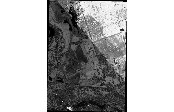
This LDQ is produced by the intensity of returns of the highest hits in
the area of coverage. It looks like a low resolution black-and-white aerial
photograph while generated from 1.5' (45cm) horizontal resolution LiDAR
scans (see attached screenshot.png). Really helpful in correlating specific
project areas to the elevation map and other features.
Carpe weekend,
Rich