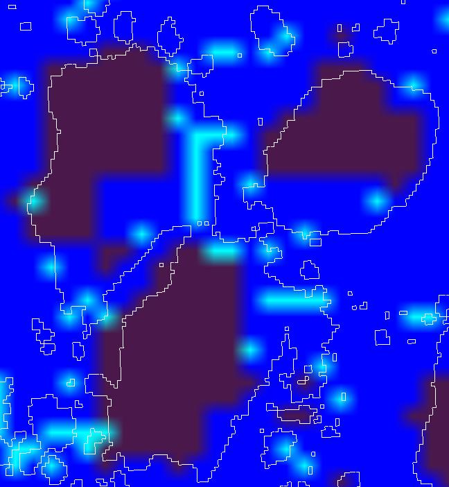
Since the annex is not uploaded successfully,I up it again.![]()
---------- Forwarded message ----------
From: maven apache <apachemaven0@gmail.com>
Date: 2009/6/22
Subject: Re: [GRASS-user] v.out.ogr to KML ERROR 1: Latitude is invalide
To: Micha Silver <micha@arava.co.il>
Cc: grass-user@lists.osgeo.org
Thanks Micha for his help!
Following his advise, I install the qgis,and the grass plugin and create new location(epsg4326),and reproj my vector map to this proj,then export it to kml successfully,however when add the kml to googlearth I found the layer doesnot match the tiff,the annex can give a clear explaination.
The reason I export the map to kml and add it to googlearth is to make a thecmatic map by their areas(I have five vector maps),also I found the d.vect.thecmatic is to make this kind of map ,however I did not sure the “column” parameter,I wonder this commond is useful for my goal?
2009/6/21 Micha Silver <micha@arava.co.il>
maven apache wrote:
I am using 6.3,my tiff info:
Coordinate System is:
PROJCS[“WGS 84 / UTM zone 20S”,
GEOGCS[“WGS 84”,
DATUM[“WGS_1984”,
SPHEROID[“WGS 84”,6378137,298.2572235630016,
AUTHORITY[“EPSG”,“7030”]],
AUTHORITY[“EPSG”,“6326”]],
PRIMEM[“Greenwich”,0],
UNIT[“degree”,0.0174532925199433],
AUTHORITY[“EPSG”,“4326”]],
PROJECTION[“Transverse_Mercator”],
PARAMETER[“latitude_of_origin”,0],
PARAMETER[“central_meridian”,-63],
PARAMETER[“scale_factor”,0.9996],
PARAMETER[“false_easting”,500000],
PARAMETER[“false_northing”,10000000],
UNIT[“metre”,1,
AUTHORITY[“EPSG”,“9001”]],
AUTHORITY[“EPSG”,“32720”]]First I create location :g.proj -c georef=d:/swilAlphaTIFF.tif datumtrans=0 location=newlocation
then import it to the new location: get four raster maps(it has three band),I composite them and then transfer the composted raster to vector,then extract each category to a vector,one of them is named bule.
Then I start to covert the projection.
I creation new epsg4326 location: then "v.proj input=bule location=newlocation mapset=PERMANENT dbase=D:\GrassDataBase output=newblue
But when I display the newblue it is blank,just like the projection is not matched…
I … have no idea.=============================
Actually I have exported the vector data to shapefile ,then use arcgis to transfer the shapefile to kml,but I think the accurcy is low…2009/6/19 Hamish <hamish_b@yahoo.com mailto:[hamish_b@yahoo.com](mailto:hamish_b@yahoo.com)>
Hamish:
create a new lat/lon WGS84 location with EPSG code #
4326, then pull in maps from source mapset using r.proj, v.proj.maven:
I have lose my heart so… So many
people have gave me help,…I can not do it.ok probably that I broke g.proj in 6.4.0rc5 makes it my fault that you
can’t create any new locationssorry.
try this:
start grass from the command line with
grass64 -text
then type a new location name, esc-enter, and create new Lat/Lon
location.
follow prompts, when it asks for a datum type “wgs84”.or try to install another version besides 6.4.0rc5
(not 6.5svn or 7svn either).Maven:
Don’t lose heart! It seems you’ve already made some good progress.
Based on Hamish’s suggestion (older version of GRASS) maybe you should try QGIS with it’s GRASS plugin.
On windows it’s fairly easy to install the whole package with the OSGeo4W installer. Follow carefully the instructions here:
http://sites.google.com/site/eospansite/qsig-for-windows
THen start QGIS, and activate the GRASS plugin, and there’s a button on the GRASS toolbar to create a new location. You select the GISDBASE (D:\GrassDataBase) then use the EPSG ID (4326) to define projection (Be sure to click the “Find” button) , and you should be up and running in the new Lat/Lon location.
Now use v.proj (from the QGIS GRASS toolbox) to project your vector from UTM to the new LatLon location, and then find v.out.ogr (again in the QGIS GRASS toolbox ) to make the kml file.
BTW, If you prefer, you can close QGIS right after creating the location, and then open GRASS in this new Lat/Lon location and do these last two steps from within GRASS.Micha
good luck,
HamishThis mail was received via Mail-SeCure System.
grass-user mailing list
grass-user@lists.osgeo.org
http://lists.osgeo.org/mailman/listinfo/grass-userThis mail was received via Mail-SeCure System.
(attachments)