Dear all,
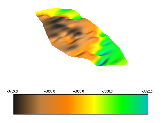
I'm working on a 3D vector map of a geological surface. I tried to
interpolate the points with v.surf.rst getting an elevation raster map
which is attached to this email as image. The surface changes its depth along a
curved line (see the attachment). Is there a way to tune the v.surf.rst
command in order to make it take into account of the curvature?
Is "tcurv" option doing it? and if yes, how can I use it? I mean, what
kind of value should I put as tcurv?
thanks to all
cheers
Francesco
(attachments)
Francesco Mirabella wrote:
Dear all,
I'm working on a 3D vector map of a geological surface. I tried to
interpolate the points with v.surf.rst getting an elevation raster map
which is attached to this email as image. The surface changes its depth along a
curved line (see the attachment). Is there a way to tune the v.surf.rst
command in order to make it take into account of the curvature?
Is "tcurv" option doing it?
tcurv=string
Output tangential curvature raster file
Hi Maciej and list,
thanks for your reply, I will try to get some more info about tangential
curvatures.
By the way, does anyone know if GEOLOGICAL SURFACES like fault planes or
bedding planes (not "phenomena", like gas emissions, etc.) can be modeled with
v.surf.rst? or with some other grass-command? Has anyone done it?
cheers
Francesco
On Wed, Oct 25, 2006 at 05:05:19PM +0200, Maciej Sieczka wrote:
Francesco Mirabella wrote:
> Dear all,
> I'm working on a 3D vector map of a geological surface. I tried to
> interpolate the points with v.surf.rst getting an elevation raster map
> which is attached to this email as image. The surface changes its depth along a
> curved line (see the attachment). Is there a way to tune the v.surf.rst
> command in order to make it take into account of the curvature?
> Is "tcurv" option doing it?
tcurv=string
Output tangential curvature raster file
Hi Francesco,
it is possible "model" discontinuous features (the gully example in the GRASS
book [1] comes to mind) however there are important limitations that you must
consider. Try searching past archives of this list- for some rather long
discussions on a similar topic: breaklines, rst, nnbathy.
Maciej has implemented an alternate interpolator which may do what you need.
Post back with your results, or further questions if the archives do not help.
Cheers,
Dylan
On Thursday 26 October 2006 03:18, Francesco Mirabella wrote:
Hi Maciej and list,
thanks for your reply, I will try to get some more info about tangential
curvatures.
By the way, does anyone know if GEOLOGICAL SURFACES like fault planes or
bedding planes (not "phenomena", like gas emissions, etc.) can be modeled
with v.surf.rst? or with some other grass-command? Has anyone done it?
cheers
Francesco
On Wed, Oct 25, 2006 at 05:05:19PM +0200, Maciej Sieczka wrote:
> Francesco Mirabella wrote:
> > Dear all,
> > I'm working on a 3D vector map of a geological surface. I tried to
> > interpolate the points with v.surf.rst getting an elevation raster map
> > which is attached to this email as image. The surface changes its depth
> > along a curved line (see the attachment). Is there a way to tune the
> > v.surf.rst command in order to make it take into account of the
> > curvature? Is "tcurv" option doing it?
>
> tcurv=string
> Output tangential curvature raster file
_______________________________________________
grassuser mailing list
grassuser@grass.itc.it
http://grass.itc.it/mailman/listinfo/grassuser
--
Dylan Beaudette
Soils and Biogeochemistry Graduate Group
University of California at Davis
530.754.7341