Hello all,
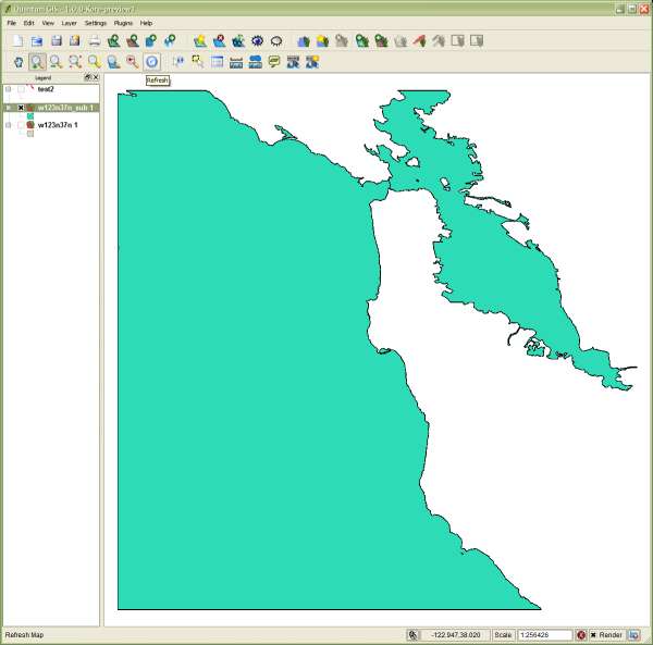
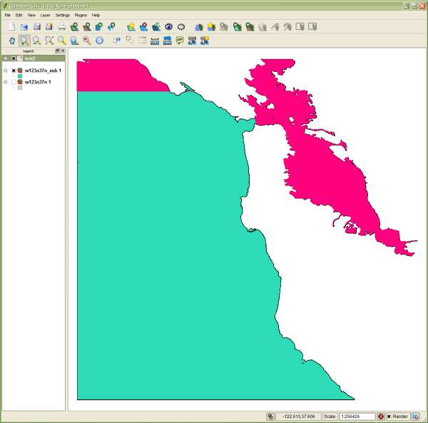
I’m having an issue with v.to.rast when converting a SRTM water body database (SWBD) shapefile to a raster. I’ve imported the file using v.in.ogr with no problems, but when I do v.to.rast, it only converts a portion of the largest polygon. I’ve attached screenshots from QGIS, one of the source vector and another with the output raster layered on top. As you can see, it’s not a region issue and there is no mask present. The region is set to the extent and resolution of the SRTM tile for that area.
command:
v.to.rast input=w123n37n_sub output=test2 use=val
The “_sub” suffix is because I filtered the original file where FACC_code = BA040. I’ve tried doing the filtering with ogr2ogr beforehand and importing the subset, as well as importing the full shapefile and using v.extract. The end raster was the same.
Thanks!
-Jamie
source file:
ftp://e0srp01u.ecs.nasa.gov/srtm/version2/SWBD/SWBDwest/w123n37n.zip
If you can’t view the attachments:
http://picasaweb.google.com/jaadfoo/Grass?authkey=jXvWPmZdHMc#
(attachments)
Hmmm, the mailing list archive doesn’t show any text. Here goes without attachments…
Apologies if this came through before…
On Wed, Oct 1, 2008 at 4:29 PM, Jamie Adams <jaadfoo@gmail.com> wrote:
Hello all,
I’m having an issue with v.to.rast when converting a SRTM water body database (SWBD) shapefile to a raster. I’ve imported the file using v.in.ogr with no problems, but when I do v.to.rast, it only converts a portion of the largest polygon. I’ve attached screenshots from QGIS, one of the source vector and another with the output raster layered on top. As you can see, it’s not a region issue and there is no mask present. The region is set to the extent and resolution of the SRTM tile for that area.
command:
v.to.rast input=w123n37n_sub output=test2 use=val
The “_sub” suffix is because I filtered the original file where FACC_code = BA040. I’ve tried doing the filtering with ogr2ogr beforehand and importing the subset, as well as importing the full shapefile and using v.extract. The end raster was the same.
Thanks!
-Jamie
source file:
ftp://e0srp01u.ecs.nasa.gov/srtm/version2/SWBD/SWBDwest/w123n37n.zip
If you can’t view the attachments:
http://picasaweb.google.com/jaadfoo/Grass?authkey=jXvWPmZdHMc#