I am trying to define a location based on epsg:31466
A table shows-up which expects a "difficult" choice between 7 options. I
would like to "cover" the mosel river and part of the "Rheintal".
I would pick the 5th choice (West-Middle) but I rather ask first "why
the 5th and not the last one which covers the whole of Germany?".
Any German epxerts?
Thank you,
Nikos
On Mon, 2008-06-09 at 20:56 +0200, Nikos Alexandris wrote:
I am trying to define a location based on epsg:31466
A table shows-up which expects a "difficult" choice between 7 options. I
would like to "cover" the mosel river and part of the "Rheintal".
I would pick the 5th choice (West-Middle) but I rather ask first "why
the 5th and not the last one which covers the whole of Germany?".
Any German epxerts?
Thank you,
Nikos
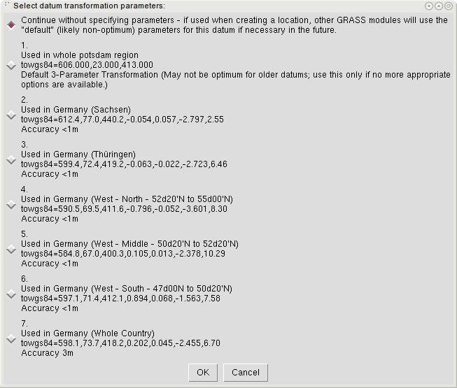
Sorry for not being very clear (and thank you Markus for your interest).
Attached is a screenshot (a .png file -- not sure if this is allowed in
the mailing list -- but it's not possible to copy-paste from this pop-up
menu).
Thank you,
Nikos
(attachments)
On Mon, Jun 9, 2008 at 9:11 PM, Nikos Alexandris
<nikos.alexandris@felis.uni-freiburg.de> wrote:
On Mon, 2008-06-09 at 20:56 +0200, Nikos Alexandris wrote:
I am trying to define a location based on epsg:31466
A table shows-up which expects a "difficult" choice between 7 options. I
would like to "cover" the mosel river and part of the "Rheintal".
I would pick the 5th choice (West-Middle) but I rather ask first "why
the 5th and not the last one which covers the whole of Germany?".
Any German epxerts?
Thank you,
Nikos
Sorry for not being very clear (and thank you Markus for your interest).
Attached is a screenshot (a .png file -- not sure if this is allowed in
the mailing list -- but it's not possible to copy-paste from this pop-up
menu).
The choice is rather easy:
- "whole country" has a precision of 3m
- the other, regionally optimized zone have better than 1m precision
So, you'd better take the one optimized for your region.
Markus
On Mon, 2008-06-09 at 21:37 +0200, Markus Neteler wrote:
On Mon, Jun 9, 2008 at 9:11 PM, Nikos Alexandris
<nikos.alexandris@felis.uni-freiburg.de> wrote:
> On Mon, 2008-06-09 at 20:56 +0200, Nikos Alexandris wrote:
>> I am trying to define a location based on epsg:31466
>>
>> A table shows-up which expects a "difficult" choice between 7 options. I
>> would like to "cover" the mosel river and part of the "Rheintal".
>>
>> I would pick the 5th choice (West-Middle) but I rather ask first "why
>> the 5th and not the last one which covers the whole of Germany?".
>>
>> Any German epxerts?
>>
>>
>> Thank you,
>>
>> Nikos
>
>
> Sorry for not being very clear (and thank you Markus for your interest).
>
> Attached is a screenshot (a .png file -- not sure if this is allowed in
> the mailing list -- but it's not possible to copy-paste from this pop-up
> menu).
The choice is rather easy:
- "whole country" has a precision of 3m
- the other, regionally optimized zone have better than 1m precision
So, you'd better take the one optimized for your region.
Markus
My problem is that I am not sure if one of the options (besides the
whole-country) deals with the bounding box of my interest:
Those are (in metres)
N: 5580000 S: 5490000
E: 2644000 W: 2534000
And I am not sure whiche transformation parameters to use to convert
them to degrees 
On Mon, 2008-06-09 at 21:40 +0200, Nikos Alexandris wrote:
My problem is that I am not sure if one of the options (besides the
whole-country) deals with the bounding box of my interest:
Those are (in metres)
N: 5580000 S: 5490000
E: 2644000 W: 2534000
And I am not sure whiche transformation parameters to use to convert
them to degrees
For example, is the following transformation correct?
gdaltransform -s_srs epsg:31466 -t_srs epsg:4326
2534000 5490000
6.46925611791806 49.5458035746045 5.23711311891839
2534000 5580000
6.4771846139954 50.3549233866055 3.37402869747075
2644000 5490000
7.9886508632139 49.5296632215733 4.35285628430074
2644000 5580000
8.02222474710927 50.3383168074372 2.4900523843271
That is latitude ranging from 49.5458035746045 to 50.3549233866055
Then I should use option 6 (?)
It just that I am not sure about the exact transformation parameters.
Nikos
On Mon, Jun 9, 2008 at 9:40 PM, Nikos Alexandris
<nikos.alexandris@felis.uni-freiburg.de> wrote:
On Mon, 2008-06-09 at 21:37 +0200, Markus Neteler wrote:
On Mon, Jun 9, 2008 at 9:11 PM, Nikos Alexandris
<nikos.alexandris@felis.uni-freiburg.de> wrote:
> On Mon, 2008-06-09 at 20:56 +0200, Nikos Alexandris wrote:
>> I am trying to define a location based on epsg:31466
>>
>> A table shows-up which expects a "difficult" choice between 7 options. I
>> would like to "cover" the mosel river and part of the "Rheintal".
>>
>> I would pick the 5th choice (West-Middle) but I rather ask first "why
>> the 5th and not the last one which covers the whole of Germany?".
>>
>> Any German epxerts?
>>
>>
>> Thank you,
>>
>> Nikos
>
>
> Sorry for not being very clear (and thank you Markus for your interest).
>
> Attached is a screenshot (a .png file -- not sure if this is allowed in
> the mailing list -- but it's not possible to copy-paste from this pop-up
> menu).
The choice is rather easy:
- "whole country" has a precision of 3m
- the other, regionally optimized zone have better than 1m precision
So, you'd better take the one optimized for your region.
Markus
My problem is that I am not sure if one of the options (besides the
whole-country) deals with the bounding box of my interest:
Those are (in metres)
N: 5580000 S: 5490000
E: 2644000 W: 2534000
And I am not sure whiche transformation parameters to use to convert
them to degrees
Better post this a new summary to the PROJ4 list...
In any case, you need to stick to the GK-zones.
Maybe of interest:
http://spatialreference.org/ref/epsg/31466/
Markus