Hi everyone,
I’m new in Grass, i have a vector map with points, and i need to create a new (buffer) map that groups with colors the ranges of distance from each point.
What commands and parameters can i use ?
Thanks,
Hi everyone,
I’m new in Grass, i have a vector map with points, and i need to create a new (buffer) map that groups with colors the ranges of distance from each point.
What commands and parameters can i use ?
Thanks,
Hi and welcome to GRASS ml!
For your problem, the starting point is this:
http://grass.itc.it/grass61/manuals/html61_user/v.buffer.html
For this problem, you could also use the GRASS plugin inside QGIS...
Luca
Alle 03:50, martedì 14 marzo 2006, David Jaramillo ha scritto:
Hi everyone,
I'm new in Grass, i have a vector map with points, and i need to create a
new (buffer) map that groups with colors the ranges of distance from each
point.What commands and parameters can i use ?
Thanks,
--
"E' molto più bello sapere qualcosa di tutto, che tutto di una cosa (Blaise
Pascal)."
GENTOO-GIS Development Team
jabber: casagrande@jabber.linux.it
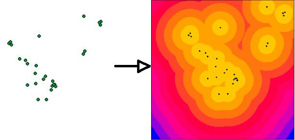
Hi everyone,
I have tested v.buffer but i can’t get several buffers, just only one. I attach an image that show you what i need.
Thanks a lot.
On 3/14/06, Luca Casagrande <luca.casagrande@gmail.com> wrote:
Hi and welcome to GRASS ml!
For your problem, the starting point is this:http://grass.itc.it/grass61/manuals/html61_user/v.buffer.html
For this problem, you could also use the GRASS plugin inside QGIS…
Luca
Alle 03:50, martedì 14 marzo 2006, David Jaramillo ha scritto:
Hi everyone,
I’m new in Grass, i have a vector map with points, and i need to create a
new (buffer) map that groups with colors the ranges of distance from each
point.What commands and parameters can i use ?
Thanks,
–
“E’ molto più bello sapere qualcosa di tutto, che tutto di una cosa (Blaise
Pascal).”GENTOO-GIS Development Team
jabber: casagrande@jabber.linux.it
hi,
just try r.buffer && r.to.vect
jachym
On Wed, Aug 16, 2006 at 03:36:20PM -0500, David Jaramillo wrote:
Hi everyone,
I have tested v.buffer but i can't get several buffers, just only one. I
attach an image that show you what i need.Thanks a lot.
On 3/14/06, Luca Casagrande <luca.casagrande@gmail.com> wrote:
>
>Hi and welcome to GRASS ml!
>For your problem, the starting point is this:
>
>http://grass.itc.it/grass61/manuals/html61_user/v.buffer.html
>
>For this problem, you could also use the GRASS plugin inside QGIS...
>
>Luca
>
>Alle 03:50, martedì 14 marzo 2006, David Jaramillo ha scritto:
>> Hi everyone,
>>
>> I'm new in Grass, i have a vector map with points, and i need to
>create a
>> new (buffer) map that groups with colors the ranges of distance from
>each
>> point.
>>
>> What commands and parameters can i use ?
>>
>> Thanks,
>
>--
>"E' molto più bello sapere qualcosa di tutto, che tutto di una cosa
>(Blaise
>Pascal)."
>
>GENTOO-GIS Development Team
>jabber: casagrande@jabber.linux.it
>
>
>
--
Jachym Cepicky
e-mail: jachym.cepicky@centrum.cz
URL: http://les-ejk.cz
GPG: http://les-ejk.cz/gnupg_public_key/jachym_cepicky-gpg_public_key.asc
-----------------------------------------
OFFICE:
GDF-Hannover
Mengendamm 16d
30177 Hannover
Germany
e-mail: cepicky@gdf-hannover.de
URL: http://gdf-hannover.de
Tel.: +49 511-39088507
Or,
try r.cost with a constant cost function
i.e. in the spearfish sample dataset:
#make a raster with constant value
r.plane name=const elevation=1 type=int easting=593786.1875
northing=4919369.0625
#calculate distance from bugsites
r.cost -k in=const out=bugsites_dist start_points=bugsites
#quantize as required
r.reclass ....
see attached
Cheers,
On Wednesday 16 August 2006 13:53, Jachym Cepicky wrote:
hi,
just try r.buffer && r.to.vect
jachym
On Wed, Aug 16, 2006 at 03:36:20PM -0500, David Jaramillo wrote:
> Hi everyone,
>
> I have tested v.buffer but i can't get several buffers, just only one. I
> attach an image that show you what i need.
>
> Thanks a lot.
>
> On 3/14/06, Luca Casagrande <luca.casagrande@gmail.com> wrote:
> >Hi and welcome to GRASS ml!
> >For your problem, the starting point is this:
> >
> >http://grass.itc.it/grass61/manuals/html61_user/v.buffer.html
> >
> >For this problem, you could also use the GRASS plugin inside QGIS...
> >
> >Luca
> >
> >Alle 03:50, martedì 14 marzo 2006, David Jaramillo ha scritto:
> >> Hi everyone,
> >>
> >> I'm new in Grass, i have a vector map with points, and i need to
> >
> >create a
> >
> >> new (buffer) map that groups with colors the ranges of distance from
> >
> >each
> >
> >> point.
> >>
> >> What commands and parameters can i use ?
> >>
> >> Thanks,
> >
> >--
> >"E' molto più bello sapere qualcosa di tutto, che tutto di una cosa
> >(Blaise
> >Pascal)."
> >
> >GENTOO-GIS Development Team
> >jabber: casagrande@jabber.linux.it
--
Dylan Beaudette
Soils and Biogeochemistry Graduate Group
University of California at Davis
530.754.7341
