Did you enjoy
nprocs=integer Number of threads for parallel computing
Did you enjoy
nprocs=integer Number of threads for parallel computing
As this is crucial, I am adding more people, so maybe we move this to the right direction ![]()
@neteler @wenzeslaus @martinl @annakrat
what would you suggest to aim for a metadata structure, that will be after used by tools? beside wavelength and other band wise metadata we must add additional ones to make processing possible. For now all the metadata stored by i.hyper has a dummy scheme, as it is simply written in comments and then parsed. We should update this somehow in a better way, then refactor all the i.hyper tools to follow it, then build other tools based on that. That metadata scheme should also be extendable. Any hints?
Thanks, will try, so far exporting the whole rast3d and running r.mapcalc on each band takes few minutes, then I r.to.rast3d with all of the metadata in description
One suggestion is to use write the metadata into a JSON and save them with the 3D raster (e.g. grid3/<mapname>/hyper.json). I am sending Alen a separate email with AI-generated code that could be a good start.
Only 2d mapcalc is parallel for now. I am not sure whether the 3D can be similarly parallelized.
Alen told me he reads all his needs (by chunk) in a numpy array, then computes everything and writes back, though I understand the attraction for that as a prototype, it puts r3.mapcalc into a drawer. But then, I also preferred the r.mapcalc at this point too for speed reasons. We have to think a bit about all that eventually.
For atmospheric correction, I will need to read several things from the images header. Non exhaustive list:
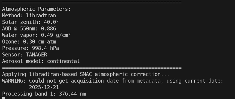
Integration of libradtran input generation into SMAC, getting there. Need to get timestamp in, it is using today’s date as satellite acquisition date…
As discussed, i Will dig in @annakrat suggestions, then suggest a metadata structure (what you wrote + other) and when agreed, try to implement it and refactor all the other modules to account it.
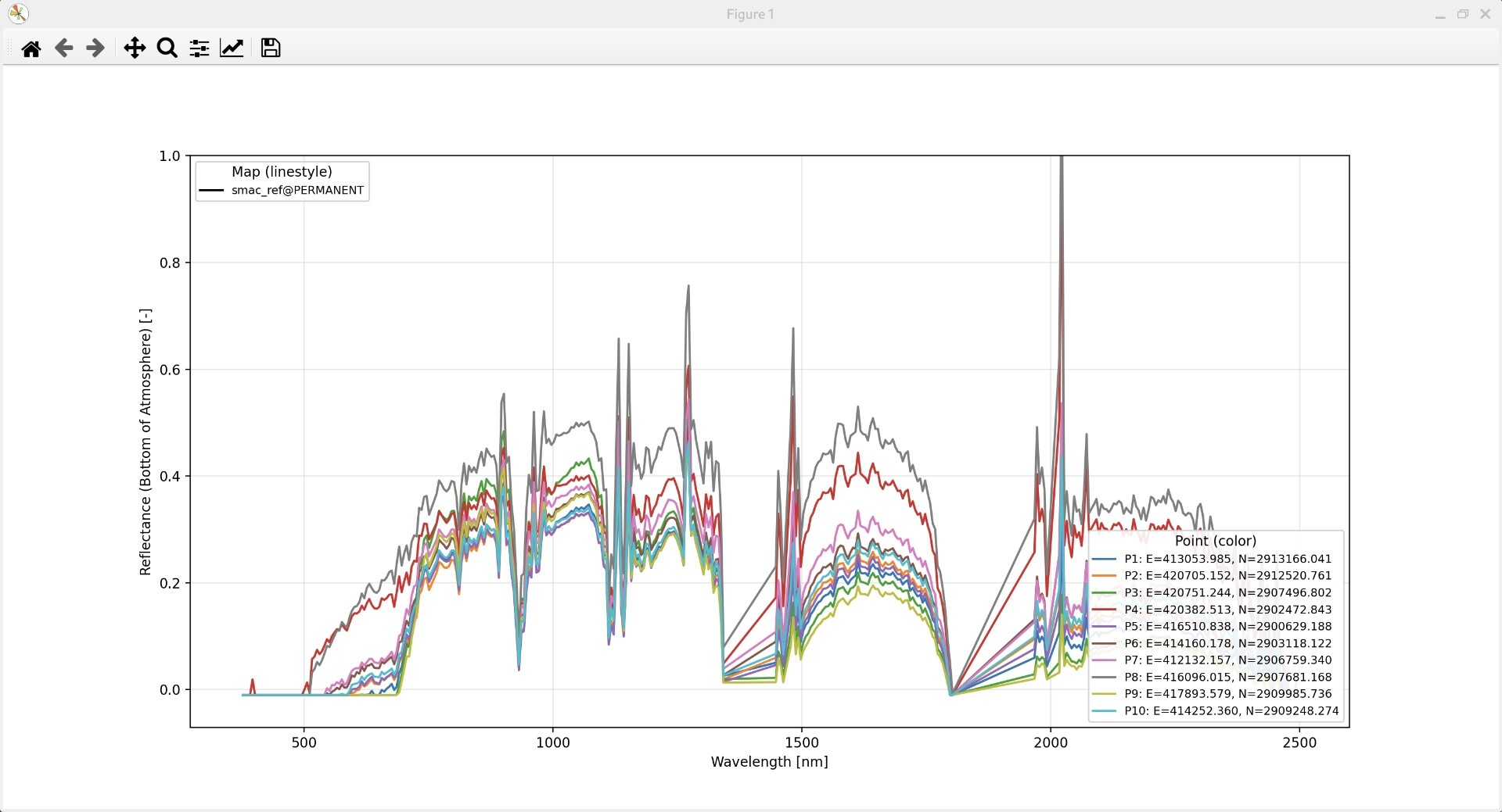
also, can you add in i.hyper.explore the option of min/max manual threshold values? I need to see the curves output from i.hyper.SMAC, but there are few negative values, and one huge positive value ruining the quality of the reflectance curves. Thank you
Ok!
My plan is to dig into it in the second part of February.
For now:
After that (testing + PR) It will be the time to jump on other functionalities under the same metadata:
I wanted also to add a module for soil moisture content, starting with NRAL.
Hi, looking forward to a unified and detailed metadata system, so I can continue building hyper addons directly with them.
I am using Tanager Agri sample of Kanpur (India) for i.hyper.smac
When you start working on Soil Moisture, please do check with me if it is not already in my TODO/DONE list
@mazingaro Please indicate the day when the PR for metadata is live, so I can be sure to start modifying codes to adopt the structure, thanks a million
GitHub - YannChemin/libsixsv: C + OpenMP port of 6s V2.1. atmospheric correction library · GitHub >This is the main 6S engine behind i.atcorr, but its vectorised version, and distributed with OpenMP on multi-core, or on GPU Offload. This is the core engine for i.atcorr2 and i.hyper.atcorr. The library has a dev version that has C includes and Python bindings (import libsixsv). The repository has a Debian building part that builds the Debian Package for distribution if needed.
Still under construction ![]() We will write here immediately after the PR
We will write here immediately after the PR
Looks great! Do we need extra metadata that is not on this list?
Hi @mazingaro
copy and paste in a local editor for best view.
This is the full list of metadata that would be best for radiance (L1) raster3d information for processing i.hyper.atcorr. Some can be preprocessed on import of the data in GRASS, some metadata are needed to store atmospheric correction parameters found.
Acquisition geometry (eliminate required sza=, vza=, raa=, altitude=,
doy=)
┌────────────────────────┬──────────────────────┬──────────────────────
───────────────────────────────┐
│ Key │ Example │
Why useful │
├────────────────────────┼──────────────────────┼──────────────────────
───────────────────────────────┤
│ Acquisition time │ 2024-06-15T10:23:45Z │ Auto-compute doy;
optionally drive solar position │
├────────────────────────┼──────────────────────┼──────────────────────
───────────────────────────────┤
│ Scene center latitude │ 45.23 │ Combined with time
→ auto sza/saa via possol │
├────────────────────────┼──────────────────────┼──────────────────────
───────────────────────────────┤
│ Scene center longitude │ 6.78 │ Same
│
├────────────────────────┼──────────────────────┼──────────────────────
───────────────────────────────┤
│ Sun zenith angle │ 34.5 │ Direct read → drop
sza= requirement │
├────────────────────────┼──────────────────────┼──────────────────────
───────────────────────────────┤
│ Sun azimuth angle │ 162.3 │ Needed for terrain
correction; currently always CLI │
├────────────────────────┼──────────────────────┼──────────────────────
───────────────────────────────┤
│ View zenith angle │ 8.2 │ Mean VZA for push-
broom sensors │
├────────────────────────┼──────────────────────┼──────────────────────
───────────────────────────────┤
│ View azimuth angle │ 100.0 │ For RAA computation
│
├────────────────────────┼──────────────────────┼──────────────────────
───────────────────────────────┤
│ Sensor altitude │ 705.0 │ Constant per
sensor; > 900 = satellite convention │
└────────────────────────┴──────────────────────┴──────────────────────
───────────────────────────────┘
Radiometry (critical for physical correctness)
┌─────────────────┬──────────────┬─────────────────────────────────────
────────────────────┐
│ Key │ Example │ Why useful
│
├─────────────────┼──────────────┼─────────────────────────────────────
────────────────────┤
│ Radiance units │ W/(m2 sr um) │ Assumed but never validated; W/(m2
sr nm) = ×1000 error │
├─────────────────┼──────────────┼─────────────────────────────────────
────────────────────┤
│ Radiance scale │ 0.01 │ If stored as scaled integers (many
L1 products) │
├─────────────────┼──────────────┼─────────────────────────────────────
────────────────────┤
│ Radiance offset │ 0.0 │ Same — L_physical = scale × DN +
offset │
└─────────────────┴──────────────┴─────────────────────────────────────
────────────────────┘
These are per-band in ENVI headers; a scene-wide version handles most
cases.
Scene-mean atmosphere (populate aod_val=, h2o_val=, ozone= defaults)
┌────────────────────────┬─────────┬───────────────────────────────────
──────────────────┐
│ Key │ Example │ Why useful
│
├────────────────────────┼─────────┼───────────────────────────────────
──────────────────┤
│ AOD 550nm │ 0.12 │ From AERONET/MODIS matchup at
acquisition time │
├────────────────────────┼─────────┼───────────────────────────────────
──────────────────┤
│ Column H2O (g/cm2) │ 2.1 │ From ECMWF/MODIS at acquisition
time │
├────────────────────────┼─────────┼───────────────────────────────────
──────────────────┤
│ Ozone (DU) │ 310 │ From OMI/Copernicus climatology
│
├────────────────────────┼─────────┼───────────────────────────────────
──────────────────┤
│ Surface pressure (hPa) │ 900.0 │ DEM-derived scene mean; seeds
cfg->surface_pressure │
├────────────────────────┼─────────┼───────────────────────────────────
──────────────────┤
│ Atmosphere model │ midsum │ Geographic/seasonal climatology
│
└────────────────────────┴─────────┴───────────────────────────────────
──────────────────┘
Proposed extended format
Hyperspectral Metadata:
Valid Bands: 224
Acquisition time: 2024-06-15T10:23:45Z
Scene center latitude: 45.234
Scene center longitude: 6.782
Sun zenith angle: 34.52
Sun azimuth angle: 162.3
View zenith angle: 8.2
View azimuth angle: 278.1
Sensor altitude: 705.0
Radiance units: W/(m2 sr um)
Radiance scale: 1.0
Radiance offset: 0.0
AOD 550nm: 0.12
Column H2O (g/cm2): 2.1
Ozone (DU): 312
Surface pressure (hPa): 900.0
Atmosphere model: midsum
Band 1: 400.5 nm, FWHM: 5.2 nm
Band 2: 405.5 nm, FWHM: 5.2 nm
…
Priority ranking
Proposed output metadata groups
Physical quantity
┌────────────────────┬───────────────────────────┬─────────────────────
────────────────────────────────────┐
│ Key │ Example │
Why │
├────────────────────┼───────────────────────────┼─────────────────────
────────────────────────────────────┤
│ Data type │ Surface reflectance (BOA) │ Distinguishes from
radiance, TOA reflectance, NBAR │
├────────────────────┼───────────────────────────┼─────────────────────
────────────────────────────────────┤
│ Units │ dimensionless │ Explicit; avoids
confusion with scaled integer products │
├────────────────────┼───────────────────────────┼─────────────────────
────────────────────────────────────┤
│ Valid range │ -0.01 to 1.50 │ Matches the clip
bounds in the correction loop │
├────────────────────┼───────────────────────────┼─────────────────────
────────────────────────────────────┤
│ BRDF normalization │ NBAR (Ross-Li) or none │ Critical: NBAR
output has different angular meaning │
└────────────────────┴───────────────────────────┴─────────────────────
────────────────────────────────────┘
Correction provenance
┌─────────────────────┬───────────────────────────────────────────┬────
───────────────────────────────────────┐
│ Key │ Example │
Why │
├─────────────────────┼───────────────────────────────────────────┼────
───────────────────────────────────────┤
│ Source radiance map │ L_DESIS_20240615 │
Full traceability back to input │
├─────────────────────┼───────────────────────────────────────────┼────
───────────────────────────────────────┤
│ Processing datetime │ 2026-03-19T14:32:00Z │
Reproducibility │
├─────────────────────┼───────────────────────────────────────────┼────
───────────────────────────────────────┤
│ Software │ i.hyper.atcorr 2.0.0 / libgrass_sixsv 8.6 │
Version locking │
├─────────────────────┼───────────────────────────────────────────┼────
───────────────────────────────────────┤
│ LUT file │ /data/scene.lut │
Which LUT was used (or “computed inline”) │
└─────────────────────┴───────────────────────────────────────────┴────
───────────────────────────────────────┘
6SV geometry and atmosphere used
These are the actual values consumed by the correction — not
defaults, but what was actually applied:
┌──────────────────────────────┬─────────────────────────────────────┐
│ Key │ Example
│
├──────────────────────────────┼─────────────────────────────────────┤
│ Sun zenith angle (deg) │ 34.52
│
├──────────────────────────────┼─────────────────────────────────────┤
│ Sun azimuth angle (deg) │ 162.3
│
├──────────────────────────────┼─────────────────────────────────────┤
│ View zenith angle (deg) │ 8.2
│
├──────────────────────────────┼─────────────────────────────────────┤
│ Relative azimuth angle (deg) │ 115.9
│
├──────────────────────────────┼─────────────────────────────────────┤
│ Day of year │ 167
│
├──────────────────────────────┼─────────────────────────────────────┤
│ Sensor altitude (km) │ 705.0
│
├──────────────────────────────┼─────────────────────────────────────┤
│ Atmosphere model │ midsum
│
├──────────────────────────────┼─────────────────────────────────────┤
│ Aerosol model │ continental
│
├──────────────────────────────┼─────────────────────────────────────┤
│ AOD 550nm │ 0.12 or per-pixel map: aod_ddv
│
├──────────────────────────────┼─────────────────────────────────────┤
│ Column H2O (g/cm2) │ 2.1 or per-pixel map: h2o_retrieved
│
├──────────────────────────────┼─────────────────────────────────────┤
│ Ozone (DU) │ 312
│
├──────────────────────────────┼─────────────────────────────────────┤
│ Surface pressure (hPa) │ 900.0
│
└──────────────────────────────┴─────────────────────────────────────┘
The per-pixel map: form matters — downstream tools need to
know whether the correction was spatially uniform or
heterogeneous.
Processing flags applied
┌────────────────────────┬───────────────────────────────────┬─────────
──────────────────────────────────────────┐
│ Key │ Example │
Why │
├────────────────────────┼───────────────────────────────────┼─────────
──────────────────────────────────────────┤
│ AOD retrieval │ DDV (-a) │
Affects AOD provenance │
├────────────────────────┼───────────────────────────────────┼─────────
──────────────────────────────────────────┤
│ H2O retrieval │ 940nm band-depth (-w) │ Same
for H2O │
├────────────────────────┼───────────────────────────────────┼─────────
──────────────────────────────────────────┤
│ O3 retrieval │ Chappuis (-z) or fixed │
│
├────────────────────────┼───────────────────────────────────┼─────────
──────────────────────────────────────────┤
│ Pressure retrieval │ O2-A (-p) or fixed │
│
├────────────────────────┼───────────────────────────────────┼─────────
──────────────────────────────────────────┤
│ Quality mask │ yes (-m) │
│
├────────────────────────┼───────────────────────────────────┼─────────
──────────────────────────────────────────┤
│ OE retrieval │ joint AOD+H2O (-e) │
│
├────────────────────────┼───────────────────────────────────┼─────────
──────────────────────────────────────────┤
│ MAP regularisation │ yes (-r) │
Changes spectral smoothness of output │
├────────────────────────┼───────────────────────────────────┼─────────
──────────────────────────────────────────┤
│ Adjacency correction │ PSF 1.0 km or none │
│
├────────────────────────┼───────────────────────────────────┼─────────
──────────────────────────────────────────┤
│ Spatial smoothing │ 3.0 px or none │
│
│ sigma │ │
│
├────────────────────────┼───────────────────────────────────┼─────────
──────────────────────────────────────────┤
│ Vector RT (Stokes) │ yes (-P) or scalar │
│
├────────────────────────┼───────────────────────────────────┼─────────
──────────────────────────────────────────┤
│ SRF gas correction │ reptran fine or none │
Triggered automatically; affects narrow-band │
│ │ │
sensors │
├────────────────────────┼───────────────────────────────────┼─────────
──────────────────────────────────────────┤
│ FlexBRDF │ MCD43 7-band disaggregation or │
│
│ │ none │
│
└────────────────────────┴───────────────────────────────────┴─────────
──────────────────────────────────────────┘
Quality / masked bands
┌────────────────────┬───────────────────────────┬─────────────────────
───────────────────────────────────────┐
│ Key │ Example │
Why │
├────────────────────┼───────────────────────────┼─────────────────────
───────────────────────────────────────┤
│ Gas-masked bands │ 107-112, 136-141, 168-175 │ Bands where T_down
× T_up < 0.10; must not use for indices │
├────────────────────┼───────────────────────────┼─────────────────────
───────────────────────────────────────┤
│ Masked pixel count │ 1234 │ From quality
bitmask (-m flag) │
├────────────────────┼───────────────────────────┼─────────────────────
───────────────────────────────────────┤
│ DASF output map │ dasf_scene │ If DASF was
computed │
└────────────────────┴───────────────────────────┴─────────────────────
───────────────────────────────────────┘
The gas-masked bands list is particularly important — it is currently
computed inside the correction loop but never
recorded anywhere, so downstream spectral analysis tools have no way
to know which bands are unreliable without
rerunning the correction.
For the uncertainty output map specifically
If uncertainty= is written, it needs its own metadata:
┌────────────────────────┬───────────────────────────────────┐
│ Key │ Example │
├────────────────────────┼───────────────────────────────────┤
│ Data type │ Reflectance uncertainty (1-sigma) │
├────────────────────────┼───────────────────────────────────┤
│ Units │ dimensionless │
├────────────────────────┼───────────────────────────────────┤
│ Uncertainty model │ NEdL propagation + AOD sigma=0.04 │
├────────────────────────┼───────────────────────────────────┤
│ Source reflectance map │ rho_surface │
└────────────────────────┴───────────────────────────────────┘
Priority ranking
Hi, another angle at finding basic geological information from i.hyper. addons, please update about the availability of the new metadata system
Hi,
yet another angle at analysis an image by specific absorption bands.