Hi, one item that is not yet complete from our designer is for a vertical pull-up/pop-up banner. I would like to get some further ideas or recommendations for background graphics. I see a couple different areas that we could use images for - the designer would go through them and see which ones might be good to include.
I'm thinking something for web mapping, another for desktop, and somehow something showing programming. It could be a screenshot, or portion of, or some particular tool concept or result that is especially pretty. For example, I'm wondering if putting the OpenLayers GUI zoom tool, a cool 3D GRASS or OSSIMPlanet screenshots and/or a desktop GIS mapping example - these are all easy ways to describe what we do. Something like the OL GUI makes an instant impression because people naturally think "web map" when they see it.
Could use our default crop circle background + compass logo (or a
series of project logos).
GIS is often presented as a map fading to vector representation ...
could we do that using starting from an initial desktop / web map /
etc... application.
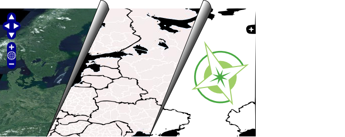
Taking that a step further; have three "sheets" lifting up, a sheet
with the web map; a sheet with the vector representation (or xml if
you are crazy) and a sheet with the OSGeo logo. This would imply the
programming that supports the web map; and the foundation that
supports the programming. Here is an example using open layers....
OSGeo as the base layer for web mapping
Jody
On Sat, May 30, 2009 at 5:45 AM, Tyler Mitchell (OSGeo)
<tmitchell@osgeo.org> wrote:
Hi, one item that is not yet complete from our designer is for a vertical
pull-up/pop-up banner. I would like to get some further ideas or
recommendations for background graphics. I see a couple different areas
that we could use images for - the designer would go through them and see
which ones might be good to include.
I'm thinking something for web mapping, another for desktop, and somehow
something showing programming. It could be a screenshot, or portion of, or
some particular tool concept or result that is especially pretty. For
example, I'm wondering if putting the OpenLayers GUI zoom tool, a cool 3D
GRASS or OSSIMPlanet screenshots and/or a desktop GIS mapping example -
these are all easy ways to describe what we do. Something like the OL GUI
makes an instant impression because people naturally think "web map" when
they see it.