I think we need to support MULTILINESTRING because the shapefile loader creates then by default. I understand that "real" MULTILINESTRING objects may not make sense but we can also just state the ALL MULTILINESTRING objects will be treated as those it is a valid contiguous path from start point to end point and that it is the users responsibility for model the graph correctly if they have a different interpertation of what a MULTILINESTRING means in their models.
Hi Mario,
Thank you for this information!
Which files exactly do you mean with "wrapper sql files"?
So this means the line geometry MUST be LINESTRING from now? Or is there
an alternative function to ST_startpoint?
Maybe it's better that import tools like osm2po create a correct
geometry type as MULTILINESTRING doesn't make sense really for a routing
network anyway.
In the past it just didn't matter if you had LINESTRING or
MULTILINESTRING, right?
I will create a ticket for this.
Daniel
On Wed, Jun 20, 2012 at 5:40 AM, Mario Basa <mario.basa@gmail.com
<mailto:mario.basa@gmail.com>> wrote:
Daniel,
You might want to limit st_startpoint usage in your devel-2.0
wrapper sql files. According to documentation:
Changed: 2.0.0 no longer works with single geometry
multilinestrings. In older versions of PostGIS -- a single line
multilinestring would work happily with this function and return the
start point. In 2.0.0 it just returns NULL like any other
multilinestring. The older behavior was an undocumented feature, but
people who assumed they had their data stored as LINESTRING may
experience these returning NULL in 2.0 now.
I used osm2po to create the Japan networks and am getting nulls when
I use st_startpoint.
Mario.
On Tue, Jun 19, 2012 at 6:10 PM, Daniel Kastl <daniel@georepublic.de
<mailto:daniel@georepublic.de>> wrote:
Hi Mario,
I think it's a good idea to drop CGAL if possible ... and you
proofed that it is possible.
I guess that PostGIS 2.0 will soon become a standard, so if we
now want to make a bigger cleanup and new release of pgRouting
it's OK to require PostGIS 2.0 in my opinion. There haven't been
many questions about driving distance on the lists, so I assume
there are not so many users of this function either.
If you move it into "core" (which is a good idea), please don't
commit it into "master" branch for now.
I would propose to either make a different branch for that, that
we can merge later, or use "devel-2_0" branch, which already
contains code cleanup:
https://github.com/pgrouting/pgrouting/tree/devel-2_0
Daniel
On Tue, Jun 19, 2012 at 11:11 AM, Mario Basa
<mario.basa@gmail.com <mailto:mario.basa@gmail.com>> wrote:
Hi,
It really is possible now to take away CGAL from pgRouting
since st_concavehull of PostGIS 2 can create the same alpha
shape. I have already managed to compile diriving-dist
without CGAL installed by modifying the cmake files and
drivedist.c.
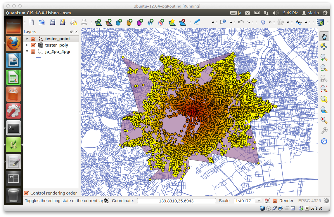
I used this:
select st_concavehull(st_collect(
st_geomfromewkt('srid=4326;POINT('||x1||'
'||y1||')')),0.7) from jp_2po_4pgr,
driving_distance('SELECT
id,source,target,cost,reverse_cost from jp_2po_4pgr
where
st_contains(ST_GeomFromEWKT(''SRID=4326;POLYGON((139 35,139
36,140 36,140 35,139 35))''),
the_geom) = true',156598,0.07,false,false) where id =
edge_id;
to create the drive time polygon in the attached screen
dump. The performance isn't so bad even with a 0.7 target
percent parameter for the concave hull.
I am planning to clean up routing_dd.sql and
routing_dd_wrapper.sql and start using the newer st_*
postgis functions.
Will there be any objections if I move routing_dd into core
instead of extra since it will now only use BOOST to compile.
Mario.
_______________________________________________
pgrouting-dev mailing list
pgrouting-dev@lists.osgeo.org
<mailto:pgrouting-dev@lists.osgeo.org>
http://lists.osgeo.org/mailman/listinfo/pgrouting-dev
--
Georepublic UG & Georepublic Japan
eMail: daniel.kastl@georepublic.de
<mailto:daniel.kastl@georepublic.de>
Web: http://georepublic.de/>
_______________________________________________
pgrouting-dev mailing list
pgrouting-dev@lists.osgeo.org <mailto:pgrouting-dev@lists.osgeo.org>
http://lists.osgeo.org/mailman/listinfo/pgrouting-dev
_______________________________________________
pgrouting-dev mailing list
pgrouting-dev@lists.osgeo.org <mailto:pgrouting-dev@lists.osgeo.org>
http://lists.osgeo.org/mailman/listinfo/pgrouting-dev
--
Georepublic UG & Georepublic Japan
eMail: daniel.kastl@georepublic.de <mailto:daniel.kastl@georepublic.de>
Web: http://georepublic.de/>
_______________________________________________
pgrouting-dev mailing list
pgrouting-dev@lists.osgeo.org
http://lists.osgeo.org/mailman/listinfo/pgrouting-dev