I'm trying to figure out how the driving_distance function works.
Here's my sql:
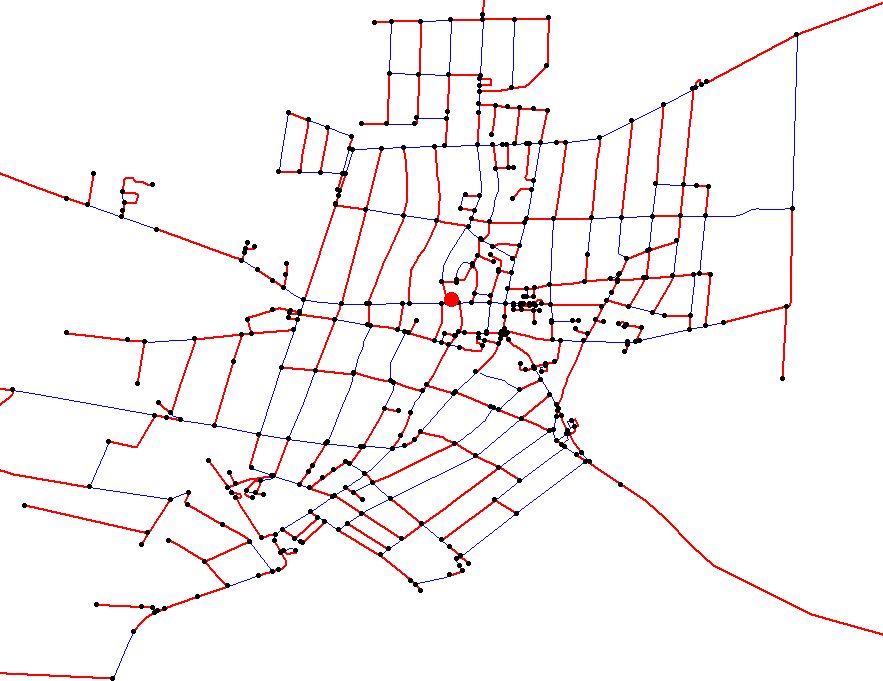
SELECT * FROM driving_distance('SELECT id::int4,f_junc::int4 AS
source,t_junc::int4 AS
target,ST_Length(ST_Transform(the_geom,23700))::float8 AS cost FROM
omsz_network',3094421,22500,false,false);
The nodes in the given distance are returned correctly, but in case of
edges some of them are returned, some other not.
See attached image:
Red dot is the starting point,
black dots are nodes returned by the function.
Red lines are the edges returned.
Blue lines are all the street network.
What am I doing wrong that not all the edges are returned in the
driving distance?
Thank you,
Csaba
--
Sándor Csaba
szolgáltatási vezető
ViaMap Kft.
Székhely/postacím: 1132 Budapest, Váci út 60-62.
Iroda:
1076 Budapest, Garay u. 29-31. I. 1.
(EMLA Környezeti Management és Jog Egyesület)
Driving distance only returns valid nodes.
The edge column is there to make the output look the same as the other functions … we can discuss this is a good idea or not.
Sorry for the confusion. Maybe this should be written somewhere more clearly.
I’m trying to figure out how the driving_distance function works.
Here’s my sql:
SELECT * FROM driving_distance(‘SELECT id::int4,f_junc::int4 AS
source,t_junc::int4 AS
target,ST_Length(ST_Transform(the_geom,23700))::float8 AS cost FROM
omsz_network’,3094421,22500,false,false);
The nodes in the given distance are returned correctly, but in case of
edges some of them are returned, some other not.
See attached image:
Red dot is the starting point,
black dots are nodes returned by the function.
Red lines are the edges returned.
Blue lines are all the street network.
What am I doing wrong that not all the edges are returned in the
driving distance?
Thank you,
Csaba
–
Sándor Csaba
szolgáltatási vezető
ViaMap Kft.
Székhely/postacím: 1132 Budapest, Váci út 60-62.
Iroda:
1076 Budapest, Garay u. 29-31. I. 1.
(EMLA Környezeti Management és Jog Egyesület)
I can still join the network table back to the resulting node list and
figure out all edges that are concerned.
Csaba
2011/3/23 Daniel Kastl <daniel@georepublic.de>:
Driving distance only returns valid nodes.
The edge column is there to make the output look the same as the other
functions ... we can discuss this is a good idea or not.
Sorry for the confusion. Maybe this should be written somewhere more
clearly.
Daniel
2011/3/23 Sandor Csaba <sandor.csaba@viamap.hu>
Hi List,
I'm trying to figure out how the driving_distance function works.
Here's my sql:
SELECT * FROM driving_distance('SELECT id::int4,f_junc::int4 AS
source,t_junc::int4 AS
target,ST_Length(ST_Transform(the_geom,23700))::float8 AS cost FROM
omsz_network',3094421,22500,false,false);
The nodes in the given distance are returned correctly, but in case of
edges some of them are returned, some other not.
See attached image:
Red dot is the starting point,
black dots are nodes returned by the function.
Red lines are the edges returned.
Blue lines are all the street network.
What am I doing wrong that not all the edges are returned in the
driving distance?
Thank you,
Csaba
--
Sándor Csaba
szolgáltatási vezető
ViaMap Kft.
Székhely/postacím: 1132 Budapest, Váci út 60-62.
Iroda:
1076 Budapest, Garay u. 29-31. I. 1.
(EMLA Környezeti Management és Jog Egyesület)