wmts get tile

Using Geoserver to publish image data , setting the tile set information for wmts, it was found that the TopLeftCorner in TileMatrix at different levels is different. Is this a normal phenomenon? The requested data is partially offset, and it is unclear what the reason is.
use EPSG:4326 minX:118 minY:22.5 maxX:121 maxY:46
tileWidth:64 tileHeight:64
The scale of layer 0 is 1:279541132.0143589.
However, in the GetCapabilities return XML of wmts, the tile matrix set has different TopLeftCorner within it。
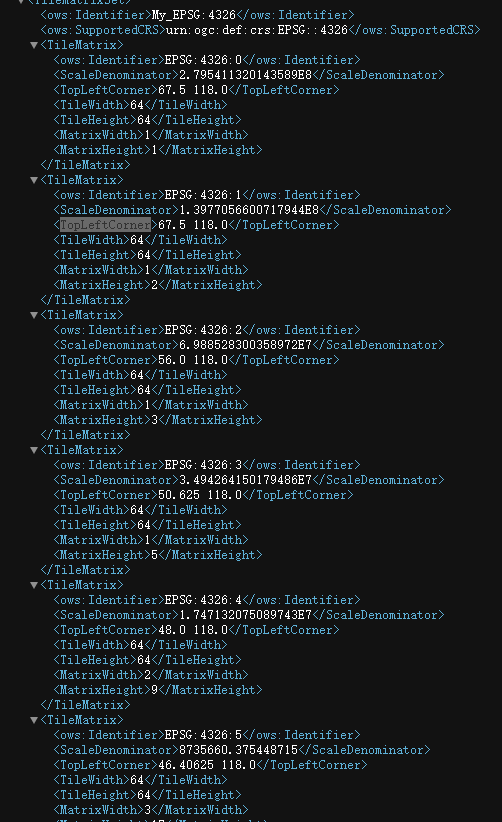
WHY?

See the image at Tiled web map - Wikipedia. Imagine what tiles are needed for covering, let’s say South America, at different zoom levels. The minimum bounding box is more accurate at higher zoom levels and smaller tiles. If all TileMatrixes were defined to cover the same area than level 0 there would be lots of empty tiles at higher zoom levels. Both options are correct by the WMTS standard.

-Jukka Rahkonen-

1 Like

To learn about Using GeoWebCache in GeoServer, watch this video:
:point_right: https://www.youtube.com/watch?v=EFve2CFf9mA&list=PL_ITaxp1Ob4sZE7iJwjQT0KPSfP7kJNs9 :point_left:

To explore the various WMS and WMTS functions, check out this video:
:point_right: https://youtube.com/watch?v=mRcl9E5ywXA&list=PL_ITaxp1Ob4u5DBn_b8xSXjYcmbgYKgVu :point_left: